Life Long Learning Mapping Project
|
 |

 |
| Preamble |
|---|
|
This page links you to/ gives you access to/ from this page you can access:
|


Life Long Learning? Comenius? BoostOSM?
The Comenius project was approved in 2011 within the Comenius program for Life Long Learning of the European Union EU. The official title of the project is: "To boost local and international tourism with OpenStreetMap". The project's acronym is: "BoostOSM"
- The project has a website here: International OpenStreetMap Project
- The project has a page on
 ComeniusBoostOsm
 - We are in European Shared Treasure I am in EST!.
Who we are ... from Slovenia, Romania, Portugal, Turkey, Germany?
On the linked wiki pages you will find the OpenStreetMap related work teachers and students are doing in 5 different countries in 5 different languages. These pages are not translated pages. Each country produces/has its own wiki, according to the needs of OSM in each country. See esp: Wiki pages, the students translated with help from teachers in Romania, Slovenia and Turkey.
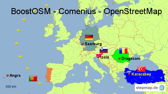

You may select a country on the map above or select it from the BoostOSM navigation bar. Click "show" on the right of buttonbar below and then select the country.
Our schools in OSM - of course a sustainable result of the project ;-)
- Click on the image for a bigger screenshot
Slovenia browse map
Romania browse map
Portugal browse map
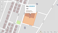
Turkey browse map
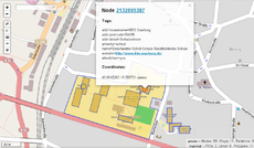
Germany browse map


Why this wiki?
We think, our project could be a good example for other schools to start a similar project to help to achieve the goals of OSM or other FOSS projects. Students can learn a lot (see below) not in a "fictional situations", but in real life.
- Contribution to OSM: - We show the contribution of each country to the wiki and to the map.
- Tools we used: - We show the tools, we used to collaborate during the project for our "projectmanagement".
- Project development: We explain the tasks, the development and the controlling.
- Contact: - Please see the site of the participating countries (above and/or below). Email in different languages (TR, SL, PT, RO or DE) to osm_comenius (at) googlegroups.com are welcome. The mailinglist will be open for your questions even when the project is finished.
What are the aims?
The main objective of this international project for schools is to complete respectively to widen the free OpenStreetMap in the countries involved (Germany, Turkey, Slovenia, Portugal and Romania). During the project students from different nations cooperate by completing map files of the different regions on OpenStreetMap that have not been completed so far and add so-called POIs.
In the same way marketing strategies using OSM are developed to take advantage of them for the promotion of tourism in the relevant regions.
Moreover, intercultural aspects, as much as the use of modern web technologies (web2.0), play an essential role in this project. Meetings of the schools involved enable students to get to know other cultures and languages. Within the two years the students take advantage of modern web2.0 technologies to communicate with the participants (mailing lists, blogs, social networks etc.) when they are not at the meetings. By doing so they learn to use them reasonably and efficiently.
Can I see your application form?
Of course. We hope you will apply for a simliar project to help FOSS Projects.
You can download an excerpt from the main part of our application here: ![]() Objectives
Objectives
How can I apply for a similar project?
For more information about Comenius projects in general, please contact your "National Agency" in your country.
- Slovenia: - Nacionalna agencija Center Republike Slovenije za mobilnost in evropske programe izobraževanja in usposabljanja
- Portugal: - Agência Nacional PROALV - Programa Aprendizagem ao Longo da Vida
- Romania: - Agenţia Naţională pentru Programe Comunitare în Domeniul Educaţiei şi Formării Profesionale-Comenius
- Turkey: - Avrupa Birliği Eğitim ve Gençlik Programları Merkezi Başkanlığı
- Germany: PAD - Die Nationale Agentur für EU-Programme im Schulbereich im PAD
. .
Results and products of the BoostOSM project
The students and teachers from each country produced during this project various products and outcomes, both common and local (specific to the needs of each national team). Listed below are just some examples for the common results (obtained by more than one country, done in more than one language). For a more comprehensive and complete image on the project's outcomes, you should have a look at:
- for different areas of contribution Comenius_OSM_and_Tourism#Comenius_BoostOSM_as_a_part_of_the_OpenStreetMap_project
- for contributions on the map in different countries, click on the flag above
- for specific products of each country, click on the flag above:)
Translations in the OSM Wiki (additional)
| Slovenia | Romania | Portugal | Turkey | Germany |
|---|---|---|---|---|
| Beginners' guide | Beginners' guide | .. | Beginners' guide | .. |
| B-Guide 1.1.1 | Frequently Asked Questions | .. | Frequently Asked Questions | .. |
| .. | Ro:Hiking | .. | .. | .. |
| .. | Ro:Lanes | .. | .. | .. |
| .. | Ro:Speed limits | .. | .. | .. |
| .. | Ro:Key:leisure | .. | .. | .. |
| .. | Ro:Key:tracktype | .. | .. | .. |
| .. | Ro:Key:amenity | .. | .. | .. |
| .. | Ro:OSMtracker (Android) | .. | .. | .. |
The project translated the GUI of the following products (additional)
| Name | Software | Provider | Costs | Slovenia | Romania | Portugal | Turkey | Germany |
|---|---|---|---|---|---|---|---|---|
| OpenRouteService | Routing | Department of Geography (Chair of GIScience) University of Heidelberg | free | .. | http://www.openrouteservice.org | .. | .. | .. |
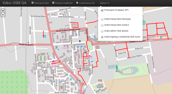
| QA Editor | Quality Assurance | Grundid GmbH | free | http://editor.osmsurround.org | http://editor.osmsurround.org | http://editor.osmsurround.org | http://editor.osmsurround.org | .. |
| Open Source Routing Machine |
Routing | Institut für theoretische Informatik | free | .. | http://map.project-osrm.org | http://map.project-osrm.org | http://map.project-osrm.org | .. |
| Kort | Gamified Mobile App to improve OSM data | Hochschule für Technik, Rapperswil, Switzerland | free | http://www.kort.ch | http://www.kort.ch | http://www.kort.ch | .. | in German available |
- OpenRouteService translations yet not made available online by the provider.
OSM QA Editor "http://editor.osmsurround.org/" in "our" languages
| Click on the image - The editor opens in the first language of your browser. Türkish, Slovenian, Portugues and Romanian versions are translated by the students during our BoostOSM Comenius project |
The project produced the following training papers (English only)
| .pdf to print as it is | .odt, .odp adapt the paper to your needs and print your own version |
|---|---|
| Data -> Upload -> Rendering -> Map | |
| not available | |
| Keys and Values cheating paper | |
| Waypoints paper | |
| Quality assurance - how to discover errors | |
| Quality assurance - how to discover errors in housenumbers | |
| How to do a roundabout? | |
| How to force rendering? |
The project's bookmark
| Front | Back |
|---|---|
 |
 |
Comenius BoostOSM as a part of the OpenStreetMap project
The mindmap below shows you the contribution of Comenius BoostOSM to OpenStreetMap. The smily (the yellow points) on the large version indicate the area, where BoostOSM contributed to the OpenStreetMap project.

Pedagogical aspects
Who will do the translations?
The main idea is that students do ... read more ...
- Beginners' guide
- FAQ
- www.openrouteservice.org
- http://editor.osmsurround.org
- and the flyer about Walking path, Wine trails, and so on.
Please observe: The center of all efforts is the student. ;-)
The main idea is that students do the translations.

- The teacher gives tasks and guidance.
- Students use the following tools
--- translate.google.com
--- www.leo.org
--- dict.cc
--- other online dictionaries
Why this procedure?
Students learn about OSM
- how to join the community so that you can contribute;
- how to collect data using a GPS unit or by other methods;
- how to upload GPS data (skip this section if you are not using GPS);
- how to edit maps to make changes to OpenStreetMap;
- how to edit data, add tags and upload changes; and
- how to render maps;
and so on ... reading this in a foreign language and
Other aspects:
- Students learn to use online translation tools;
- Students learn to translate into their native language;
- Students learn to evaluate the translations doing the translated tasks in OSM;
- Students learn to formulate so that classmates (and the public) can understand it;
- Students learn to produce helpful content for the community in a real environment; and
- Students learn to use a wiki.
- Summary
- Students learn in a complex real situation about OSM and at the same time produce translations for real life and not as a task for school.
How we prepaired mapping parties in Angra do Heroismo, PT; Karacabey, TR and Drăgăşani, RO
Before each meeting new students/teachers ... read more ...
How we prepaired mapping parties in Angra do Heroismo, PT; Karacabey, TR and Drăgăşani, RO
- Before each meeting new students/teachers
- study OSM-JOSM-OSM Map?
 about OSM JOSM and the map
 - study keys and values about keys and values and how to use it in JOSM
- study "cheating paper" with keys and values repeat the main combinations
- study OSM-JOSM-OSM Map?
- At the at appropriate school
- install JOSM on all computers;
- install in JOSM the "walking papers" plugin;
- collect / organise GPS-devices to build the international groups;
- talk with tourist office (dissemination);
- talk with mayor (dissemination);
- talk with press ... give information that students/teachers are mapping the city ;-)
- prepare maps to "divide the city";
- prepare phone list from all students and teachers (best in G-docs);
- prepare copies of "cheating paper" with keys and values for each group repeat the main combinations;
- prepare copies of the paper for waypoints for each group use for walking outside;
- prepare Walking Papers Hint: To produce Walking papers. Best for printing: Provider "CloudMade fine-line" style.; and
- prepare a scanner for uploading "walking papers"
- install JOSM on all computers;
QA tools for high-school students
We made a very short and incomplete analyse of existing tools which could be interesting to use with students:
- How can I report, discover and/or fix errors in OSM? Download here: Quality assurance
If you are interested in the original .odt to change it for your purposes feel free to send an email to osm_comenius at googlegroups dot com. (We could not upload it, because the wiki has a limitation of 2 MB and our file has 3.1 MB :-( )
- How can I correct housenumbers and streets in OSM? Download here: Quality assurance housnumbers
NOTE - see lower right corner - a new function in OSM to show students what to do
| "Note" is a new function integrated in OSM in April 2013, very helpful for showing students, where they can work and what to do. |

Problems and Solutions
The Terceira Coastline problem
Working on the coastline of an island with different teams
short description of the problem we had - and the solution in the linked file
| Link | |
|---|---|
| Download english version | |
Težave smo imeli ... na otoku Terciera (PT) in ponujena rešitev
Težave smo imeli ... na otoku Terciera (PT) in ponujena rešitev
(special thanks to Skyper)
(07. actualize the modified objects: JOSM -> FILE -> Update modified, to see conflicts very early, and not during upload)
| |
Probleme cu linia de coastă din Terceira și rezolvarea lor
Probleme cu linia de coastă din Terceira și rezolvarea lor
(multumiri lui Skyper)
(07. actualızati obiectele modificate: JOSM -> FILE -> Update modified, pentru a vedea conflictele din timp si nu ın timpul ıncarcarii)
| |
Problemas que tinhamos ... Com a linha costeira da ilha Terceira(PT) e a sua solução
Problemas que tinhamos ... Com a linha costeira da ilha Terceira(PT) e a sua solução
(Especial agradecimento a Skyper)
IDs de objetos
(07. Actualiza os objetos alterados: JOSM -> FILE -> Update modified, antes do upload, para verificar se existem conflitos )
| |
Portekiz'deki Terceira adasının kıyı şeridinde yaşadığımız problemler
ve bu problemlerin çözümleri..
(Skyper'ye teşekkürler..)
(07. değiştirilmiş parçaları gerçekleştirmek: JOSM -> FILE -> Update modified, yanlışlıkları yükleme yaparken değil çok önceden görmek için)
| |
Probleme mit der Küstenlinie in Terceira und deren Lösung
Probleme mit der Küstenlinie in Terceira und deren Lösung
(herzlichen Dank an User:Skyper)
|
To use data from OSMTracker for Android(tm)
OSMTracker for Android - a short HowTo
|
Tools for project management
Google Spreadsheet, Internal Mailinglists, OSM Lists, ...
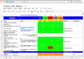
We use Google Docs Spreadsheet for our "project management". All teachers have access with read and write rights to this spreadsheet. A short explation about the sheet can be found below.
- Items: In column "A" you can see the list of tasks. We are working on different mailing lists.
- Public and private mailing lists: We created an internal mailing list for all participants of all countries (communication there: english). Some countries created an "internal" mailing list to improve communication between teachers and students. (communication on these lists: TR, PT, SL, RO, DE). All teachers are members of the relevant mailing list of their countries. The canonical list of Mailing lists available is at: * https://lists.openstreetmap.org/listinfo
- Newbies: Since the first meeting in Saarburg most of the teachers and some students are member of the "newbies mailinglist". Since not all participants mastered the use of mailing lists, this led to minor problems on the list. ;-) For the Admin it looked like spam. :-( https://lists.openstreetmap.org/pipermail/newbies/2011-September/thread.html ;-)
Click image to enlarge

- Translations: Neither the "FAQ", nor the "Beginners' Guide" were available at the beginning of the project in RO, PT, TR and SL language. So teachers with their students translated both and in so doing, learned many things about OSM. In the table above you can see, that FAQ and Beginners Guide had to be translated up until the meeting in Slovenia. The green colour in the table indicates, that this item has been completed. Some of the translations you can just find in the wiki Ro:Beginners' guide; others still need to be uploaded.
Work between two meetings
- Colours: With the help of colours we create as much transparency as possible. Every teacher can check very quickly what's still left to do and the status of the item. Teachers can give "read" rights to their students, so that they can follow the tasks and see what has to be done.
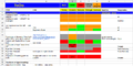
Click image to enlarge

Communication and Visibility
The mapping party in Turkey - Projemizin Medyadaki Yankıları
The project had a warm welcome in Turkey where we were honored to meet and collaborate with Dr. H. Can Ünen, Research assistant at Istanbul Technical University, and his students at our mapping party. To thank him, Istanbul Technical University and the Turkish OSM community, we will keep this part in Turkish :). See him talking about OSM and BoostOSM here: [1]
- Projemize destek veren İTÜ, Geomatik Mühendisliği Bölümü'nden Dr. H. Can Ünen, Alternatif Bilişim TV'de projemizden bahsetti. İzlemek için tıklayın.
Mapping Romania


MINT - Mathematics - IT - Natural Sciences - Technologie
We were allowed to show our project at a PAD congress "Frischen Wind in MINT" end of may 2013 in Magdeburg.


STENCIL Science Teaching European Network for Creativity and Innovation in Learning

... and ... we produced images of the week for the Main Page of OSM wiki :)
 |
 |
|---|---|
| Students and teachers from five countries meet in Saarburg, Germany to learn how to gather data, use mapping devices, feed in and maintain the OSM data. Meetings in Portugal, Slovenia, Romania and Turkey will follow as part of this two year EU funded Comenius project | Şeyma, Kader, Neslihan,(teachers: Manfred, Miray) Simge, Özge, Our project aims to tackle the issue of gender-stereotyping. Students from Karacabey, Turkey, learning how to use a tracking device (Garmin) to improve OSM in Turkey. |
 |
 |
| Students from Azores Islands, Portugal, visiting Germany on a training course in JOSM and QA Editor as part of the Life Long Learning Mapping Project | Final meeting in Dragasani and Rm. Valcea ... experienced mappers now! |
Who participates from Slovenia, Romania, Portugal, Turkey, Germany?
Comenius-Logo Disclaimer: ‘This project has been funded with support from the European Commission. This publication reflects the views only of the author, and the Commission cannot be held responsible for any use which may be made of the information contained therein.’
"Dieses Projekt wird mit Unterstützung der Europäischen Kommission finanziert. Die Verantwortung für den Inhalt dieser Veröffentlichung trägt allein der Verfasser; die Kommission haftet nicht für die weitere Verwendung der darin enthaltenen Angaben."
"Acest proiect a fost finanţat cu sprijinul Comisiei Europene. Această publicaţie reflectă doar punctual de vedere al autorului şi Comisia nu este responsabilă pentru eventuala utilizare a informaţiilor pe care le conţine."