File:Lille toile.jpg
Jump to navigation
Jump to search


No higher resolution available.
Lille_toile.jpg (548 × 549 pixels, file size: 57 KB, MIME type: image/jpeg)
Summary
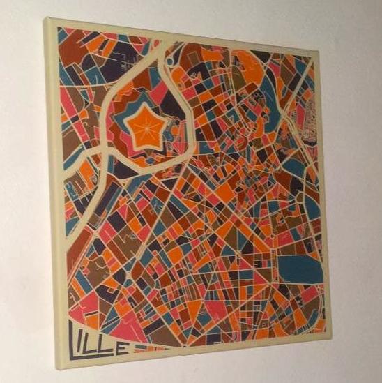
Printed canvas of this map: File:Carto_cecile2lgt.jpg
This is a Featured image, which means that it has been identified as one of the best examples of OpenStreetMap mapping, or that it provides a useful illustration of the OpenStreetMap project. If you know another image of similar quality, you can nominate it on Featured image proposals.
Front-page image for week 50 of 2013 (9–15 Dec.).
- Image descriptions
- Deutsch : Eine farbenfrohe und künstlerisch gestaltete Karte von Lille (Frankreich) mit seiner charakteristischen sternförmigen Zitadelle, erstellt mit OpenStreetMap-Daten und QGIS. Anleitung (Französisch).
- English : A colourful artistic map of Lille (France) with its characteristic star-shaped citadel, made using OpenStreetMap data and QGIS as described in the tutorial here.
- español : Un mapa artístico y colorido de Lille (Francia) con su característica ciudadela en forma de estrella, creada a partir de los datos de datos de OpenStreetMap y QGIS. Tutorial (Francés).
- français : Une représentation artistique colorée de la ville de Lille avec sa citadelle caractéristique en forme d'étoile, faite à partir des données OpenStreetMap et QGIS comme expliqué dans ce tutoriel
- italiano : Una mappa artistica molto colorata di Lille (Francia) con la sua caratteristica cittadella a forma di stella, fatta usando i dati di OpenStreetMap e QGIS come descritto in questo tutorial (in francese)
- Nederlands : Een kleurige artistieke kaart van Lille / Rijsel (Frankrijk) met zijn karakteristieke stervormige citadel. Deze kaart is gemaakt met gegevens uit OpenStreetMap en QGIS, zoals hier beschreven in de tutorial (in het Frans)
- русский : Художественная карта французского города Лилль с характерной звездовидной крепостью. Изображение создано с помощью данных OpenStreetMap и программы QGIS, процесс описан автором в блоге.
- 中文(简体) : 法国里尔的鲜艳艺术风地图,上头用星状特征像堡叠的形状拼凑,采用开放街图图资,还有如petit-atelier-cartographique-creer-une-cartographie-minimaliste-d-ilots-urbains-partir-des-d 教学文所述用QGIS加工。
- 中文(繁體) : 法國里爾的鮮豔藝術風地圖,上頭用星狀特徵像堡疊的形狀拼湊,採用開放街圖圖資,還有如教學文所述用QGIS加工。
Licensing
![]()
![]()
![]()
This work is licensed under the Creative Commons Attribution-ShareAlike 2.0 License.
Attribution not specified as a parameter! THIS LICENSE ALWAYS REQUIRES ATTRIBUTION! Use {{CC-BY-SA-2.0|Attribution, typically name of author}} See Template:CC-BY-SA-2.0 for full description how this template should be used.
Note, there is
There is also
Attribution not specified as a parameter! THIS LICENSE ALWAYS REQUIRES ATTRIBUTION! Use {{CC-BY-SA-2.0|Attribution, typically name of author}} See Template:CC-BY-SA-2.0 for full description how this template should be used.
Note, there is
{{CC-BY-SA-2.0 OpenStreetMap}} for files based on old OSM map data, before the license change made on 2012-09-12.There is also
{{OSM Carto screenshot||old_license}} for files based on old OSM map data, before the license change made on 2012-09-12, created using OSM Carto map style.
- Map data © OpenStreetMap contributors
File history
Click on a date/time to view the file as it appeared at that time.
| Date/Time | Thumbnail | Dimensions | User | Comment | |
|---|---|---|---|---|---|
| current | 21:59, 9 December 2013 | | 548 × 549 (57 KB) | Harry Wood (talk | contribs) | cropping a bit and warming the colours |
| 20:50, 9 December 2013 | 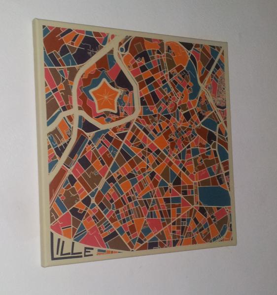 | 562 × 600 (50 KB) | Bescu (talk | contribs) | Printed canvas of this map : http://wiki.openstreetmap.org/wiki/File:Carto_cecile2lgt.jpg |
You cannot overwrite this file.
File usage
The following 6 pages use this file: