File:Nottingham tram construction diversion notice.jpg
Original file (750 × 628 pixels, file size: 166 KB, MIME type: image/jpeg)
Summary
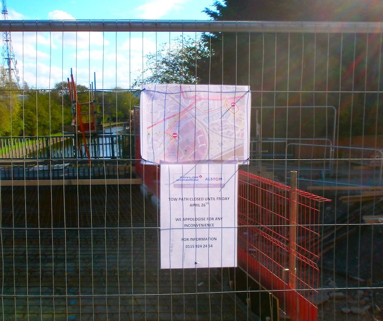
Nottingham Tram footpath diversion notice.
Clayton's Bridge![]() Clayton's Bridge (canal bridge number 13A) over the Nottingham and Beeston Canal has been strengthened to carry the Nottingham tram extension to Chilwell
Clayton's Bridge (canal bridge number 13A) over the Nottingham and Beeston Canal has been strengthened to carry the Nottingham tram extension to Chilwell![]() Nottingham tram extension to Chilwell (close to the proposed HS2 Toton station). The tram contractor used this OpenStreetMap image to inform pedestrians and cyclists how to reach the canal towpath via a temporary diverted route.
Nottingham tram extension to Chilwell (close to the proposed HS2 Toton station). The tram contractor used this OpenStreetMap image to inform pedestrians and cyclists how to reach the canal towpath via a temporary diverted route.
Note that this use of the freely licensed OSM data and osm.org tiles should be improved copyright-wise.
Three higher-resolution originals are available externally.

Front-page image for week 26 of 2013 (24–30 Jun.).
- Image descriptions
- Deutsch : Bauunternehmen im Vereinigten Königreich haben Zugriff auf sehr detaillierte Ordnance-Survey-Kartenprodukte, aber für diesen öffentlichen Aushang (Bau der neuen Straßenbahn in Nottingham) entschied sich das ausführende Bauunternehmen einfach OpenStreetMap zu verwenden. Detailliert, aktuell und frei lizenziert.
- English : UK construction firms have access to very detailed Ordnance Survey map products, but when it comes to displaying a map on a public notice, the people building the new tram in Nottingham found it easier to use OpenStreetMap. Detailed, up-to-date, and open licensed.
- français : Les entreprises de travaux publics anglaises ont accès à des cartes officielles très détaillées, mais quand il s'agit de fournir une carte pour un affichage public, ceux qui construisent le nouveau tramway de Nottingham trouvent plus facile d'utiliser OpenStreetMap.
- italiano : Le imprese edili britanniche hanno accesso a prodotti cartografici molto dettagliati dell'Ordnance Survey, ma quando si è trattato di mostrare una mappa su un avviso al pubblico, le persone che costruiscono la nuova linea tranviaria a Nottingham hanno trovato più semplice usare OpenStreetMap. Dettagliata, aggiornata e con licenza libera.
- Nederlands : Aannemers in het Verenigd Koninkrijk hebben toegang tot de zeer gedetailleerde kaarten van de topografische dienst, maar om een kaart op deze mededeling te plaatsen vonden de bouwers van de nieuwe tram in Nottingham het makkelijker om OpenStreetMap te gebruiken. Gedetailleerd, bijgewerkt en met een vrije licentie.
- 中文(简体) : 英国的建筑公司有办法取得内容相当详细的 Ordnanace Survay 地图产品,但是有显示有地图的公开告示时,诺丁顿的新街车建筑团队发现用开放街图更简单,而且相当详细、即时和开放授权。
- 中文(繁體) : 英國的建築公司有辦法取得內容相當詳細的 Ordnanace Survay 地圖產品,但是有顯示有地圖的公開告示時,諾丁頓的新街車建築團隊發現用開放街圖更簡單,而且相當詳細、即時和開放授權。
Licensing
Credit: Paul Sladen, 2013-04-26
![]()
Please, please use more specific template such as {{PD-self}} / {{PD-creator}} / {{PD-shape}} / {{PD-USGov}} / {{PD-old}} / {{PD-RU-exempt}} ... This template is not making clear why this work is in the public domain.
File history
Click on a date/time to view the file as it appeared at that time.
| Date/Time | Thumbnail | Dimensions | User | Comment | |
|---|---|---|---|---|---|
| current | 11:20, 12 June 2013 | | 750 × 628 (166 KB) | Harry Wood (talk | contribs) | cropping to be landscape for the purposes of image of the week |
| 11:17, 12 June 2013 | 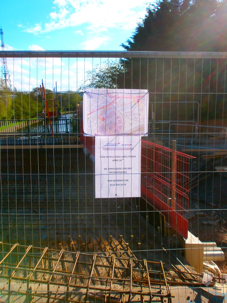 | 750 × 1,000 (280 KB) | Harry Wood (talk | contribs) | Photo from User:Sladen for image of the week |
You cannot overwrite this file.
File usage
The following 6 pages use this file: