DE:Featured images/Apr-Jun 2013
Jump to navigation
Jump to search


Hier sind die vorgestellten Bilder zu sehen. Die Bilder wurden als Vorzeigebeispiele des OpenStreetMap-Projektes auserwählt.
Wenn du ein Bild hast, welches als Bild der Woche sein könnte, dann kannst du es hier auf der (en) Vorschläge des ausgewählten Bildes-Seite vorschlagen.
| ← von April bis Juni 2012 | ← von Januar bis März 2013 | von Juli bis September 2013 → | von April bis Juni 2014 → |
Galerie der vorgestellten Bilder, von April bis Juni 2013
2013, Woche 14
2013, Woche 15
2013, Woche 16

2013, Woche 17

2013, Woche 18
2013, Woche 19

2013, Woche 20
2013, Woche 21

2013, Woche 22
2013, Woche 23
2013, Woche 24

2013, Woche 25

2013, Woche 26
Details und Beschriftungen
Woche 14 (von Montag, 1. April 2013 bis Sonntag, 7. April 2013) [Edit]

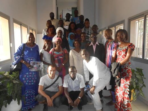
- English : Team from the Université Cheikh Anta Diop after a five day training course in AUF Dakar. 23 students and researchers focussed on mapping the Medina municipality of Dakar, Senegal. See the HOT blog write-up by Augustin Doury
- Deutsch : Team von der Université Cheikh Anta Diop nach einem Fünf-Tage Lehrgang in AUF Dakar. 23 Studenten und Forscher fokussierten dabei auf einem Kartenabschnitt von Medina Gemeinde in Dakar, Senegal. (HOT Blog geschrieben von Augustin Doury)
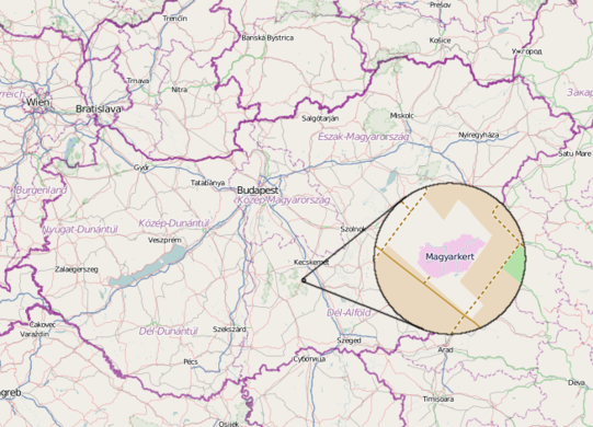
Woche 15 (von Montag, 8. April 2013 bis Sonntag, 14. April 2013) [Edit]

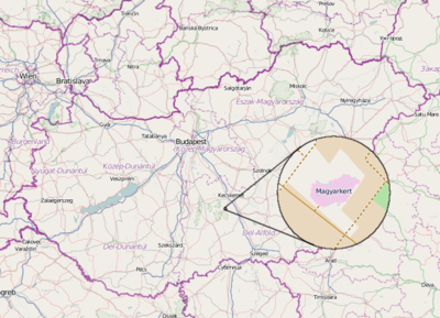
- English : Magyarkert ("HungarianGarden") is a leisure park in Hungary, shaped like the country at a 1:1000 size ratio. It includes main rivers, lakes and shapes of hills. The park's main theme is environment protection, educational programs, sport, etc, and of course it's on OpenStreetMap.
- Deutsch : Magyarkert ("Ungarn-Garten") ist ein Erholungspark in Ungarn, der wie das Land im Maßstab 1:1000 geformt ist. Er enthält Flüsse, Seen und Hügelformen. Im Park geht es vor allem um Umweltschutz, Bildungsprogramme, Sport etc., und natürlich ist er in OpenStreetMap.
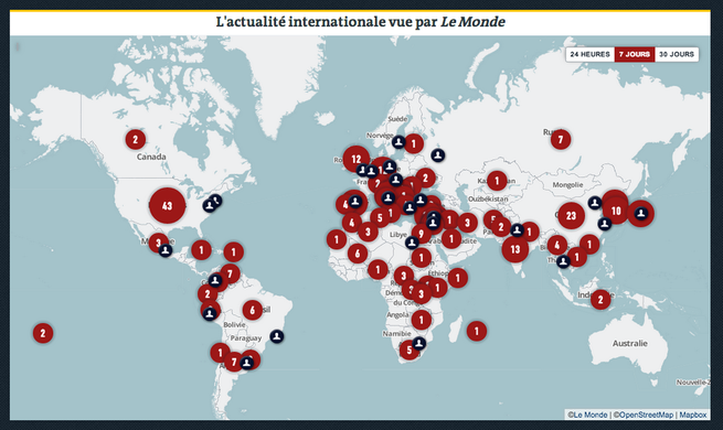
Woche 16 (von Montag, 15. April 2013 bis Sonntag, 21. April 2013) [Edit]

- English : Le Monde, one of the largest French newspapers, relaunched their online paid edition with interactive French maps powered by OpenStreetMap. Read more on the MapBox blog
- Deutsch : Le Monde, eine der größten Zeitungen in Frankreich, hat seine bezahlte Onlineversion neu aufgelegt. Für die interaktiven Karten wird OpenStreetMap genutzt. Mehr im MapBox Blog
Woche 17 (von Montag, 22. April 2013 bis Sonntag, 28. April 2013) [Edit]

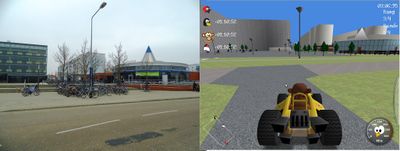
- English : Supertuxkart is a free, open-source racing game. Using 3D data from OpenStreetMap we can race around real-world street layouts, such as this suburb of Rostock
- Deutsch : Supertuxkart ist ein freies Open-Source-Spiel. Anhand der 3D-Daten von OpenStreetMapeetMap können wir durch reale Straßenlayouts fahren, so wie hier im Vorort von Rostock!
Woche 18 (von Montag, 29. April 2013 bis Sonntag, 5. Mai 2013) [Edit]

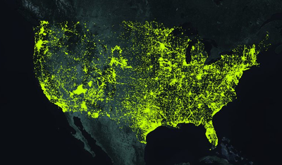
- English : Data from the top 50 mappers in the US (see full map). These big contributors have been offered a special invitation to the SOTM US conference
- Deutsch : Daten vom 50 besten Mappers in den USA (volle Karte). Sie wurden speziell zurSOTM US-Konferrenz eingeladen.
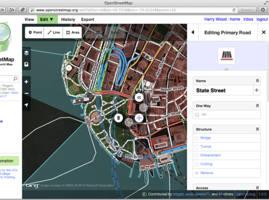
Woche 19 (von Montag, 6. Mai 2013 bis Sonntag, 12. Mai 2013) [Edit]

- English : "iD" is a new web-based OpenStreetMap editor which is coming out of testing into prime-time on the OpenStreetMap homepage this week. read more on the blog
- Deutsch : "iD" ist eine neue web-basierte OpenStreetMap Editor. Diese wird in dieser Woche aus der Testphase in die OpenStreetMap-Homepage integriert. (mehr dazu im Blog)
Woche 20 (von Montag, 13. Mai 2013 bis Sonntag, 19. Mai 2013) [Edit]

- English : State Of The Map Argentina took place a few weeks ago.
Register now for SOTM US coming very soon, and the main State Of The Map 2013 conference in Birmingham UK in a few months. - Deutsch : State Of The Map Argentinien fandet vor ein paar Wochen statt.
Jetzt anmelden für die SOTM in den USA, die bald stattfindet und für die globale State Of The Map 2013 Konferenz in Birmingham (UK), die ebenfalls in ein paar Monaten stattfindet.
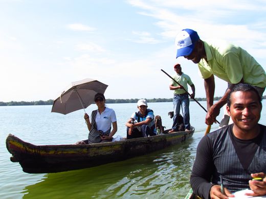
Woche 21 (von Montag, 20. Mai 2013 bis Sonntag, 26. Mai 2013) [Edit]

- English : Canoe Mapping in the mangroves. La Boquilla, Cartagena, Colombia. In a diary entry by Humberto Yances he describes his participatory mapping project involving the local community, fishermen and ecotourism associations. Follow-up workshops resulted in a map, and ongoing work on "Social Innovation for Mangrove Conservation"
- Deutsch : Kanu-Mapping in den Mangroven. La Boquilla, Cartagena, Kolumbien. In einem Tagebucheintrag von Humberto Yances beschreibt er seine partizipativen Mapping-Projekt unter Einbeziehung der örtlichen Gemeinschaft, Fischer und Ökotourismus Verbände. Workshops führte zu einer Karte und zu laufenden Arbeiten zum Thema "Soziale Innovation für Mangrove Conservation".
Woche 22 (von Montag, 27. Mai 2013 bis Sonntag, 2. Juni 2013) [Edit]

- English : Two OpenStreetMap servers waiting full of expectation for new co-worker servers for improved reliability and performance!
- Deutsch : Zwei OpenStreetMap-Server sind voller Erwartung auf neue Server-Kollegen für verbesserte Zuverlässigkeit und Leistung!
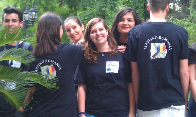
Woche 23 (von Montag, 3. Juni 2013 bis Sonntag, 9. Juni 2013) [Edit]

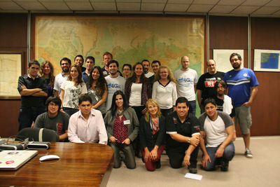
- English : Comenius Mapping Party in Romania. Persons from left to right: Dario (Portugal), Pia (Slovenia), Yaren (Turkey), Mateja (Slovenia), Hilal (Turkey), Nils (Germany).
- Deutsch : Comenius-Mapping-Party in Rumänien. Personen von links nach rechts: Dario (Portugal), Pia (Slowenien), Yaren (Türkei), Mateja (Slowenien), Hilal (Türkei), Nils (Deutschland).
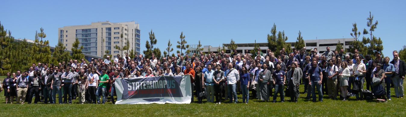
Woche 24 (von Montag, 10. Juni 2013 bis Sonntag, 16. Juni 2013) [Edit]

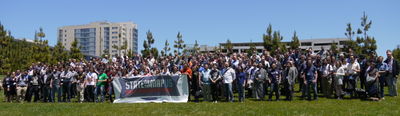
- English : Group photo of 400+(!) participants of the State Of The Map U.S. 2013, San Francisco, June 08
- Deutsch : Gruppenfoto von über 400 Teilnehmern der OSM-USA-Konferenz State Of The Map U.S. 2013 in San Francisco am 8. Juni
Woche 25 (von Montag, 17. Juni 2013 bis Sonntag, 23. Juni 2013) [Edit]

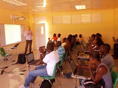
- English : Severin Menard is conducting a workshop on QGIS as a part of HOT's "Engaging the Youth to Map The Northern Corridor" in Limonade, Haiti
- Deutsch : Severin Menard hält einen Workshop über QGIS als Teil des HOT-Projekts "Engaging the Youth to Map The Northern Corridor" in Limonade, Haiti
Woche 26 (von Montag, 24. Juni 2013 bis Sonntag, 30. Juni 2013) [Edit]

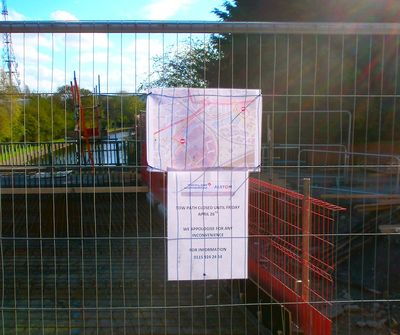
- English : UK construction firms have access to very detailed Ordnance Survey map products, but when it comes to displaying a map on a public notice, the people building the new tram in Nottingham found it easier to use OpenStreetMap. Detailed, up-to-date, and open licensed.
- Deutsch : Bauunternehmen im Vereinigten Königreich haben Zugriff auf sehr detaillierte Ordnance-Survey-Kartenprodukte, aber für diesen öffentlichen Aushang (Bau der neuen Straßenbahn in Nottingham) entschied sich das ausführende Bauunternehmen einfach OpenStreetMap zu verwenden. Detailliert, aktuell und frei lizenziert.