File:Red Cross volunteer GPS tracks in Forecariah Guinea.jpg

Original file (1,144 × 1,065 pixels, file size: 262 KB, MIME type: image/jpeg)
Summary
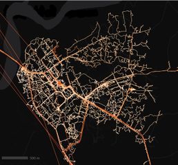
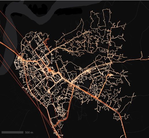
GPX tracks lighting up the map in Guinea
This past year, the American Red Cross undertook its biggest field effort to date: launching a mapping hub in West Africa and training about 100 local volunteers to visit 7,000 villages in the border regions of Liberia, Guinea, and Sierra Leone. The mapping focused on public health resources, different aspects of vulnerability, and amenities like markets that would draw people across borders – important information to understand if another outbreak were to occur.
The volunteers logged GPX tracks as they conducted the field mapping. Combined, the tracks add up to 70,000 kilometres of roads and paths travelled by the volunteers.
Here's an excerpt from the data for Forécariah, Guinea (map). Data like these have helped us to add missing roads to the network in OSM - which has been especially important for areas with cloudy satellite imagery.
This image and the above description are by User:Emilyeros and the American Red Cross. Originally tweeted here: https://twitter.com/emilyeros/status/808413358202425344

Front-page image for week 50 of 2016 (12–18 Dec.).
- Image descriptions
- English : Local volunteers trained by the American Red Cross have mapped 7,000 villages in the border regions of Liberia, Guinea, and Sierra Leone. A total of 70,000 kilometres of roads and paths, including this example, Forécariah in Guinea.
- italiano : Volontari locali formati dalla American Red Cross hanno mappato 7000 villaggi nelle regioni di confine tra Liberia, Guinea e Sierra Leone. Un totale di 70000 chilometri di strade e sentieri, incluso questo esempio, Forécariah in Guinea.
- русский : Обученные Американским Красным Крестом волонтёры картировали семь тысяч населённых пунктов на границе Либерии, Гвинеи и Сьерра-Леоне. В общей сложности добавлено около семидесяти тысяч дорог и троп, включая эти в небольшом гвинейском городе Форекария.
- 中文(简体) : 由红十字会训练的在地志工绘制利比里亚、几内亚、塞拉利昂边境一带7,000 个村庄,并且绘制总长超过70,000 公里的道路和路径,包括图中的例子,几内亚的Forécariah。
- 中文(繁體) : 由紅十字會訓練的在地志工繪製賴比瑞亞、幾內亞、獅子山邊境一帶 7,000 個村莊,並且繪製總長超過 70,000 公里的道路和路徑,包括圖中的例子,幾內亞的Forécariah。
Licensing
![]()
![]()
![]()
Attribution not specified as a parameter! THIS LICENSE ALWAYS REQUIRES ATTRIBUTION! Use {{CC-BY-SA-2.0|Attribution, typically name of author}} See Template:CC-BY-SA-2.0 for full description how this template should be used.
Note, there is
{{CC-BY-SA-2.0 OpenStreetMap}} for files based on old OSM map data, before the license change made on 2012-09-12.There is also
{{OSM Carto screenshot||old_license}} for files based on old OSM map data, before the license change made on 2012-09-12, created using OSM Carto map style.
by permission [1]
File history
Click on a date/time to view the file as it appeared at that time.
| Date/Time | Thumbnail | Dimensions | User | Comment | |
|---|---|---|---|---|---|
| current | 23:17, 12 December 2016 | | 1,144 × 1,065 (262 KB) | Harry Wood (talk | contribs) | GPX tracks lighting up the map in Guinea by User:Emilyeros and the American Red Cross. |
You cannot overwrite this file.
File usage
The following 12 pages use this file:
- Featured images/Oct-Dec 2016
- Uk:Featured images/Oct-Dec 2016
- Zh-hans:Featured images/Oct-Dec 2016
- Zh-hant:Featured images/Oct-Dec 2016
- Template:Featured image d4
- Template:Iotw image/2016-50
- DE:Featured images/Oct-Dec 2016
- FR:Featured images/Oct-Dec 2016
- ES:Imágenes destacadas/Oct-Dic 2016
- IT:Featured images/Oct-Dec 2016
- RU:Featured images/Oct-Dec 2016
- JA:Featured images/Oct-Dec 2016