Key:maxheight:physical
Jump to navigation
Jump to search
 |
| Description |
|---|
| The maximum height in metres |
| Group: restrictions |
| Used on these elements |
| Useful combination |
|
| Status: in use |
| Tools for this tag |
|
maxheight:physical expresses a physical height limit related to the tagged object and is used on ways mostly on highway=* while on nodes for example with barrier=* or amenity=parking. If no unit is included, the value is assumed to be in metres.
Example
maxheight:physical=3.2- maximum height is 3.2 m
Signs used for physical maxheight
-
 Brazil
 -
 Finland
 -
![France[1]](https://upload.wikimedia.org/wikipedia/commons/thumb/f/fb/France_road_sign_M4v.svg/120px-France_road_sign_M4v.svg.png) France[1]
France[1] -
 Indonesia
 -
 Southern African Development Community member states
 -
 United Kingdom
 -
 Hong Kong

![France[1]](/wiki/File:France_road_sign_M4v.svg)


Note
This tag is new, and still not supported by rendering or routing software, and should therefore be used together with maxheight=*.
Possible tagging mistakes
| Country | Sign | Explanation |
|---|---|---|
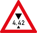
| Netherlands | 
|
This sign denotes a regulatory limit, which is always less than the physical limit, so it must be tagged as maxheight=4.2 instead of maxheight:physical=4.2. Note the regulatory limit indicated by this sign only affects exceptional transports (the value is always ≥ 4 m). In the Netherlands, a proper value for maxheight:physical=* cannot be deduced from road signs, but may be obtained from other information sources.
|
See also
maxheight=*tags the legal restriction as indicated on signage.maxheight=*andmaxheight:physical=*can be used on the same way; the latter usually having a larger value.height=*maxwidth:physical=*tags the maximum physical width for vehicles.access=*for legal access restrictions