Key:maxheight
;_StVO_1992.svg) |
| Description |
|---|
| The legal maximum height |
| Group: restrictions |
| Used on these elements |
| Documented values: 1 |
| Useful combination |
|
| See also |
| Status: de facto |
| Tools for this tag |
|
The tag maxheight=* specifies the maximum height limit for vehicles using the way to which the tag is added. In most cases this expresses a legal limit, though there are places where this is used differently. Note that if it is desirable to establish a difference between a legal and a physical maxheight, this should be the lesser of the two.
Use the tag maxheight:physical=* for physical height limits.
How to map
For a bridge, the maxheight tag should be set on the way going under the bridge. Only tag the section of the way where the maxheight road signs apply. If there are none, only the approximate section of the way which is under the bridge should be tagged with maxheight (See also OSM Help 3275).
If no unit is included, the value is assumed to be in metres. So, for example maxheight=3.8 would mean maximum height is 3.8 m.
| Height | Tagging | Remark |
|---|---|---|
| Three metres | maxheight=3 | Alternatively maxheight=3 m could be used. |
| 3.8 metres | maxheight=3.8 | Please note the dot as decimal separator! |
| 6 feet and 7 inches | maxheight=6'7" | Use a typewriter apostrophe character after the feet value and a typewriter double-quote character after the inches value. Spaces are not permitted. |
If a road is not divided but has different height restrictions based on the driving direction (for example a bridge has 13'1" when driving forward but 14'1" backward), then tag the road segment with maxheight:forward=13'1" as well as maxheight:backward=14'1". Match the direction with the segment direction in the map by checking the start point and the stop point of a segment. Do not use any direction "east/west/south/north" to describe the height restriction.
In such case adding also maxheight=13'1" would be useful - this way routers not supporting maxheight:forward=13'1" will gracefully degrade. And given that there are less than 150 such objects worldwide support is quite unlikely and should not be expected.
Non-numerical values
Some non-numerical values are in use in order to tag roads where a physical height limit exists, but no traffic signs are indicating a legal height limit. See also maxheight:signed=*.
| Value | Meaning | Remark |
|---|---|---|
| default | There isn't any traffic sign indicating a legal maxheight limit, and the physical height is sufficient for the country specific height limit of general traffic. In some countries a missing traffic sign clearly indicates that this is true.
In Germany, this does also imply a physical height of at least 4.5 m. In France, 4.3 m (but 4.75 m for motorways). |
Most frequently used maxheight value |
| below_default | There isn't any traffic sign indicating a legal maxheight limit, but the physical height is more limiting than the country specific height limit of general traffic. This value is mainly useful for private building passages, where a traffic sign might not be required by law or might be missing in spite of a legal requirement. | |
| no_indications | Neither a traffic sign nor the non-existence of a traffic sign is indicating maxheight. Also the physical height is not known well enough to decide if it is more limiting than the default country specific height limit of general traffic. | |
| no_sign | At least in case of public German roads no_sign is equivalent to default. | Being less specific than the previous values it should be replaced by one of previous values. |
| none | This value is mainly used with the meaning there is no legal height limitation other than the default height limit of general traffic. Therefore this value is intended to be equivalent to default, but some mappers might have used none with the same meaning as no_sign. At least in case of public German roads none is equivalent to default. | Typically being used below bridges and in tunnels value none is intuitively felt wrong. Therefore it is often deleted. The usage of value none is not consistent to maxspeed=none, where none really indicates there isn't any legal limit and not a default limit. |
| unsigned | This value is mainly used with the same meaning as default, but might also have the same meaning as no_sign. At least in case of public German roads it is equivalent to default. | This value seems to be a bad translation from German indicating there aren't any traffic signs. |
A missing maxheight=* tag could mean there isn't a height restriction or there is a height restriction, but nobody has mapped it yet. Therefore a tag like maxheight=default is very valuable information for truck routing. Absent signage at physical location indicates meeting height minima as set by country, or union such as the Europe. E.g. Italy will not put a sign out if the max height is at least 4.8 metres. Note that signage is likely to be missing on non-public roads, for example passages through buildings.
In addition these non-numerical values have a QA purpose by removing the missing maxheight indication from the Maxheight Map. The non-numerical values are mainly used in Germany and a few countries around, where the Maxheight Map has been used in order to collect maxheight data systematically.
Rendering
- Rendering in OSM Transport Karte: Example 4,20 m

Common mistakes
Incorrect values
Often the values themselves are not specified correctly. The following table contains examples of incorrect tags and their correct notation.
| Incorrect | Explanation | Correct |
|---|---|---|
maxheight=3.8m
|
The space between value and unit is missing. | maxheight=3.8 m |
maxheight=3.8 meters
|
The unit 'meters' is not the correct unit. | maxheight=3.8 m or maxheight=3.8 |
maxheight=0,6
|
The comma is used as wrong decimal separator. | maxheight=0.6 or maxheight=0.6 m |
maxheight=7 ft
|
The unit 'ft' is not a correct unit. Use x'y". | maxheight=7'0" |
maxheight=7'
|
Do not forget to add the inch, even if it is 0. | maxheight=7'0" |
maxheight=2.3; 7'9"
|
Only one value with unit is allowed. Choose meters or feet/inch | maxheight=2.3 m or maxheight=7'9" |
Examples
- Public roads

Australia:
maxheight=##.##
Canada (Ontario)
maxheight=3.9
(tag the underpass up ahead)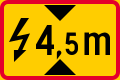
Finland:
maxheight:physical=4.5
(use a period as decimal separator, not a comma)
Hong Kong:
maxheight=4.4
Latvia:
maxheight=4.9
(tag the road under the pipeline in the distance - note that sign is marked as delayed)
Latvia:
maxheight=4.9
(tag the road under the pipeline)
Mexico:
maxheight=4.20
Mexico (Jalisco):
maxheight=4.20
Netherlands (sign used for values < 4 m):
maxheight=3.1
(use a period as decimal separator, not a comma)
Netherlands (sign used for values ≥ 4 m):
maxheight=4.2
(use a period as decimal separator, not a comma)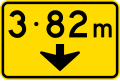
New Zealand:
maxheight=3.82
(use a period as decimal separator, not an interpunct)
United Kingdom:
maxheight=14'6"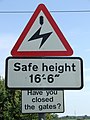
United Kingdom: maxheight=16'6" Notice that the safe height differs from physical height due to arc distance

United States:
maxheight=12'6"
(omit the hyphen; tag the underpass up ahead)
United States:
maxheight=14'4"
(use single and double quotation marks; tag the roadway below)
United States (Ohio):
maxheight=10'3"
(TODO: How to tag the 9'10" height restriction on the knee braces?)
United States (Texas):
maxheight=12'
(tag the underpass 10 miles ahead)


- Clearances under roofs – tag service roads passing underneath

Czech Republic:
maxheight=4.20
(use a period as decimal separator, not a comma)
United Kingdom:
maxheight=4.4
United States:
maxheight=7'6"
United States:
maxheight=14'
.jpg)
.jpg)


- Height restrictors – tag both height restrictor and service road

United Kingdom:
maxheight=7'10"
United States:
maxheight=8'10"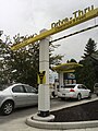
United States:
maxheight=9'


Related tags
- maxheight:physical=* for when a physical barrier (as opposed to, e.g., the law) limits the height of traffic using the way.
- barrier=height_restrictor in combination with maxheight=* for intentionally blocking higher vehicles from entering an area; e.g., a car park.
- access=* for other access restrictions
- height=* - measurement of height dimensions; e.g., for a building
- Relation:enforcement + enforcement=maxheight - permanently installed devices that measure and document traffic violations, such as maxheight
Special support in editors
- One of StreetComplete quests finds objects with missing maxheight tags and asks user to map it by answering a simple question.
External links
- Maxheight Map helps you find missing maxheight tags under (railway-)bridges and tunnel/covered. See Wiki-Page for more details.
- Category:Height limit indication road signs on Wikimedia commons