Putting Clonmel's History on the Map
For Heritage Week 2020, volunteers at OpenStreetMap Ireland and local people with an interest in history are working together. They will try to record all historical sites in Clonmel. By August 23rd (the end of traditional Heritage Week), we hope to have all buildings (churches, pubs, former schools, former RIC barracks, former creameries, etc), plaques and memorials mapped. This will help heritage enthusiasts and tourists find these places easier.
This is a great opportunity to learn how to record heritage sites and local knowledge free and easy.
Please add as many historical buildings, memorials, plaques, old street names as possible.
If you are new to OpenStreetMap, choose a simple task like adding only old street names or old pub names, so you won't get overwhelmed by the technicalities.
| DO NOT COPY from other, copyrighted maps like Ordnance Survey maps online, Google Maps, GoogleStreetView etc. Please use your own fieldwork/ research or OpenSource alternatives. |
Use the hashtag #heritage_week_osmIRL, if possible.
Why Clonmel

Every town in Ireland has a viable heritage mapping need, since every town has a history and heritage. This history could related to particular architecture that is still standing, particular sites where buildings used to be, urban street layouts, ecological heritage and planting, or even commemorated persons and things onn plaques and statues. Before choosing Clonmel an out of copyright OS map was obtained and scanned for the items that might relate to this heritage. Lots of interesting old places which have had a big formative influence on Clonmel and its people, and these are visible on this map.
Suggested Tasks
Mapillary capture (see below) of as many streets, lanes and roads as possible. There are approximately 20,000 mapillary images for the town already, most of these were captured on August 3rd 2020. To see the coverage please inspect here, and if you fancy trying to the download mapillary app to you phone and take some images the priority area yet to be covered is Cantwell Street, Queen Street, Mary's Street, Grattan Place and O'Connell Street.
Mapping of buildings (see below). Some buildings have the names of their previous business on the facade (Tyler's). These can be added under old_name.
Tracking and naming of lanes (see below). In its Medieval core, Clonmel has preserved quite a few lanes (mostly highway=footway). Due to their narrowness, they are often not visible on satellite view. Please use tracking apps to map these lanes. Some of them have name plaques and even further historical information.
Mapping Heritage Trail information boards (see under plaques etc below) and use information given for buildings described.
Add opening hours and contact information for heritage sites like museums.
Useful apps and websites for field work
Mapillary - a photographic capture app which results in data comparable to GoogleStreetview, can be used by pedestrians, on bicycles or in cars
StreetComplete - app which helps collect data about streets (names, lighting etc) and houses (house numbers/names, no. of levels, roof shapes)
OSMTracker - App to track routes which can be uploaded to OSM then. Allows the user to add notes and photographs along the way.
FieldPapers - great surveying tool for people who prefer working with paper rather than digital devices.
A FieldPapers atlas of the area has been created and can be downloaded here.
How to map using iD editor or JOSM
| Use node for traffic lights, traffic signs, plaques, benchmarks, pumps, holy wells etc. | 
|
| Use way for walls, town walls, streets, lanes, pedestrianized streets, paths etc. | 
|
| Use areas for (separate) buildings, graveyards, GAA pitches etc. | 
|
Mapping buildings
Use area to outline buildings.
| Define as building | tags | |
|---|---|---|
| essential tags | additional tags | |
| Private buildings | building=yes (but please be more specific using the following) | building:architecture=*
(for architecural period) |
| house | building=house | addr:housenumber=*
building:architecture=* (architectural style like georgian) |
| See more possibilities at building=* | ||
| Public buildings | building=public | |
| library | amenity=library
name=* |
|
| museum | tourism=museum
name=* |
opening_hours=* |
| museum type=gallery | tourism=gallery
name=* |
opening_hours=*
website=* |
| police station | amenity=police | phone=*
(for date of opening) |
| pub | amenity=pub
name=* |
opening_hours=* |
school
|
building=school (for buildings built as schools, which could now be used differently) alternatively amenity=school
|
old_name=* |
Lanes
| Essential tags | Additional tags |
|---|---|
| name= | barrier=gate (for closed-off lanes) |
| highway=footway (for pedestrianised lanes) | inscription= |
| highway=service
service=alley [for lanes with vehicle access] |
old_name= |
| tunnel=building_passage [for archways, see below] | width= (in meter) |
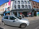
Entrance into Hopkin's Lane at 73, O'Connell Street
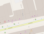
A screenshot of Hopkin's Lane showing it as
tunnel=building_passage.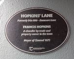
Photograph of the plaque in Hopkin's Lane
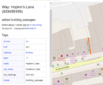
Screenshot showing the tags for Hopkin's Lane


Plaques & Memorials
Use nodes to define locations of plaques on walls or as freestanding items.
| essential tags | additional tags | |
|---|---|---|
 |
memorial=plaque
|
direction=
[add angle or wind direction of where panel is facing]
[use mapillary ID] |
 |
tourism=information
|
direction=
[add angle or wind direction of where panel is facing]
[use mapillary ID] |
_06.jpg)
|
historic=monument
inscription= |
architect=
[use mapillary ID] |
Benchmarks

Benchmarks are survey points chiselled into walls and stones. They were used by Ordnance Survey in the 19th and 20th century and some can still be found today. Only add benchmarks to the map that are actually still visible, DO NOT SIMPLY COPY their locations from old maps. Use nodes to define locations on walls.
| Essential tags | Additional tags |
|---|---|
man_made=survey_point
|
width=
|
benchmark=yes
|
ele:1913=
[elevation according to 25'' map; please add |
source=survey
|
survey_date=
|
direction=
[add direction the benchmark is facing] |
Project Timeline

The task to map all buildings was created on July 28th 2020 under the hashtag #heritage_week_osmIRL.
The buildings were completely mapped and validated in the taskmanager in the evening of July 29th 2020.
A first mapillary trip was undertaken on August 4th 2020 (data uploaded by August 9 2020).
A meeting of several mappers in Clonmel took place August 15th. This yielded a very good coverage of the core of the town as well as industrial estates in the periphery.
Work continues as basic mapping of estates and more detailed mapping in the town centre.
Useful outcomes
It will be possible for designers and printers to make customised local maps of Clonmel, free of charge and free of licence requirements other than attirubition to (C)OpenStreetMap Contributors. This can be acheived using tools like Umaps, Mapbox, or MapTiler, among others.
These maps could have a heritage interest, or be for other purposes like local nature trails, cycle ways, health walks and so on. There may be other purposes that the information can be used for, but be sure to read the general provisions of the licence terms as set out here.