Tag:amenity=place_of_worship
| Description |
|---|
| A place where religious services are conducted. |
| Rendering in OSM Carto |
| Rendering in OSM Carto |

|
| Group: religion |
| Used on these elements |
| Useful combination |
|
| Status: de facto |
| Tools for this tag |
|
How to map
All places of worship, independently of the religion or denomination, get the tag amenity=place_of_worship.
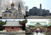
Usually, the tag is applied to buildings that are fully occupied by their worshipping function, such as mosques, churches, cathedrals, synagogues, temples. These should be co-tagged with building=mosque, building=church, building=cathedral, building=synagogue, building=temple etc. For the surrounding area, see under "Buildings" below.
Smaller edifices like crosses, prayer flags, mass rocks, lourdes grotto's, wayside shrine etc should be tagged with place_of_worship=*'s subtags, e.g. place_of_worship=mass_rock.
Combinations can be made with the following tags:
- religion=* and denomination=*
- service_times=* if a regular service is held here
- access=private is useful if it is available only for small group, for example church in a monastery used solely by monks.
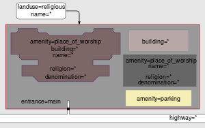
- landuse=religious may be used to demarcate the grounds surrounding an amenity=place_of_worship.
Buildings
The tag amenity=place_of_worship can be added to the surrounding area where the religious services are conducted, or on the building if the area isn't exactly known (together with the key building=*). Usually, if worship typically takes place inside a building (such as with churches, mosques and synagogues), only the building is tagged, not the whole surrounding grounds. In that case, the grounds surrounding the building (such as a churchyard) can be tagged as landuse=religious, or possibly landuse=cemetery.
If the place of religious services is located in a part of a multi-purpose building, then the tag amenity=place_of_worship should be placed on a node or area, inside the building outline. Examples are prayer rooms in public buildings or rooms rented for religious purposes in commercial buildings.
If the building contains one or more tower with bells, add one node or area per tower with man_made=tower and tower:type=bell_tower.
If the building contains one or more minaret, add one node or area per minaret with man_made=tower and tower:type=minaret.
Architectural type of buildings for worshipping
The tag building=* should be applied according to the architectural type, often such religious buildings are recognizable landmarks.
Typical tags in this context are:
- Built by adherents of a religion not further specified:
- Built by adherents to specific religions (sorted by number of adherents):
Whereas the previous tags describe the architectural category, the actual style can be described with building:architecture=*.
For example, a catholic church can be tagged on the building outline with amenity=place_of_worship + religion=christian + denomination=catholic + building=church.
Consequently, a building without the particular architectural distinction should not be given such a building value, for example a general-purpose shop building in a strip mall that is currently being used for worship should not be tagged as a building=church. Instead, the appropriate building=* tag for the major use of the building should be used, building=yes as the default.
Please note that a building retains this architectural building=* tagging even if it is no longer used for religious purposes. For example, a church building that is now used as a concert hall could be tagged as building=church + amenity=theatre.
Smaller edifices
When ceremonies of worshipping are regularly performed on dedicated areas that are not buildings, these areas should be mapped as closed ways (or node if the shape is unknown), and tagged amenity=place_of_worship and the religion details. If possible, the subtag place_of_worship=* should be given.
Examples:
- place_of_worship=cross
- place_of_worship=prayer_flags
- place_of_worship=mass_rock
- place_of_worship=lourdes_grotto
- place_of_worship=wayside_shrine
Multiple places of worship on the same grounds
When a religious site holds multiple places of worship, the site outline can be tagged with landuse=religious. The places of worship within it (buildings, shrines, open areas) should then each be tagged with amenity=place_of_worship.
Tagging examples
Cathedral, collegiate church, church, or chapel
- building=<type of building>
- amenity=place_of_worship
- name=<name of object> – (Do not confuse the name of the object with its title which is "Basilica", which is a common mistake)
- religion=<religion name>
- denomination=<denomination name>
- diocese=<name of the diocese under which the facility is subject>
- deanery=<name of the deanery under which the facility is subject>
Optionally,
- parish=* - name of the parish under which the branch church or chapel is subject.
- operator=* - name of the order governing the parish.
- church:type=* - church affiliation
- alt_name=<Cathedral ...., Collegiate ..., etc.>
- wikipedia=* - link to the church Wikipedia
- operator:wikipedia=* - link to the parish Wikipedia under which church or chapel is subject
- patron_saint=* - a saint who is regarded as the heavenly advocate of the place of worship
Presbytery
We mark this place where priests live and work as a building.
Parish office
We mark the parish office or the bishop's curia office as a node inside the outline of the object or near the node with the address (we do not add an address) and mark it as follows:
- office=religion
- name=Parish office.
- description=<full name of the office and parishes served by this office>.
- religion=<religion namei>.
- denomination=<denomination name>.
Optionally,
- opening_hours=<opening hours>.
- operator=<the name of the order or religious institution in charge of the office>.
- phone=*.
- email=*.
- fax=*.
- website=*.
- wheelchair=*.
Bell tower
Optionally,
- bell:multiple=<number of bells>
- bell:name=<the name of the individual bells>
- bell:service_times=* – some call at a specific time, e.g. every day at noon. See service_times=* for data format.
More in Optional tags for towers
Shrine
It is proposed to use for an area independent of the temple:
- place_of_worship=wayside_shrine
- shrine=international
- shrine=national
- shrine=regional – regional, in conjunction with denomination=roman_catholic means a diocesan shrine
- shrine=yes – other, undefined, of unknown rank
Example rendering
OpenStreetMap Carto renders places of worship at zoom levels:
- ≥13 area tagged as amenity=place_of_worship or landuse=religious, gray (#cdccc9)
- ≥13 building tagged as amenity=place_of_worship, 20% darker than others
- ≥16 includes symbol, depending on religion=* and denomination=*:


- ≥17 includes name
Discussion
There is no established tagging of places of worship with access only for members of matching religion/denomination though access=adherents was proposed for that purpose[1].
See also
- parish=* - name of the parish under which the branch church or chapel is subject.
- amenity=grave_yard for burial land that has a relation to the church or place of worship.
- landuse=religious for the area that the place of worship building sits within.
- A draft (still not a proposal) exists for the communities (religious or not).
Possible tagging mistakes
- ↑ mailing list discussion, example of explicit sign forbidding access for nonmuslims to a mosque [1], see also note about default access


