Tag:historic=ruins
.jpg) |
| Description |
|---|
| Remains of structures that were once complete, but have fallen into partial or complete disrepair. |
| Group: historic |
| Used on these elements |
| Useful combination |
| Status: in use |
| Tools for this tag |
|
The tag historic=ruins is used with ruins that are of historic importance, where it is not possible, or not appropriate, to be more specific about the type of structure that is now in ruins.
Good practice
historic=ruins is a generic description, that records only a limited amount of information. More specific approaches are preferred whenever it is possible to describe the original type of structure that is now in ruins. To some extent, contributors can use alternative forms to suggest the degree to which a structure is ruined. Although they both provide similar information, a form such as historic=ruins,ruins=castle suggests a structure that is mainly in ruins, while a form such as historic=castle,ruins=yes suggests a structure that still appears much like a castle.
A number of techniques have been suggested for providing further detail. See, for example, the proposal to use additional tags to add features at proposed features/ruins, or proposals to describe the civilization that created the original feature at historic:civilization=*.
Generally, most older ruins can also be described with historic=archaeological_site and its subtags.
Photos of ruins
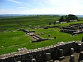
Ruins of a Roman fort on Hadrian's wall
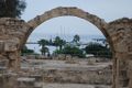
Byzantine fort

