Tag:sport=calisthenics
 |
| Description |
|---|
| Form of exercise consisting of a variety of exercises that uses the body's own weight as the load. |
| Group: sports |
| Used on these elements |
| Useful combination |
| Status: in use |
| Tools for this tag |
|
sport=calisthenics is resistance training that uses body weight as the load.
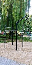
In urban spaces, calisthenics can be practised in dedicated areas called Street workout park, Calisthenics park, Outdoor gym etc. In which there is infrastructure in the form of horizontal and vertical bars, placed at different heights.
Equipment used in calisthenics includes bars, handrails, ladders and gymnastic rings.
Street workout is also a social movement promoting physical activity and a healthy lifestyle.
How to map
Set a node or draw as an area along the dedicated to calisthenics area outline. Then add the tag leisure=fitness_station + sport=calisthenics
Tags used in combination
- name=*
- surface=* - grass, sand, tartan, woodchips etc
- lit=*
- manufacturer=* - manufacturer
The use of Street Workout is allowed for people no younger than 15 years and no shorter than 140 cm (information contained in the regulations of Street Workaut), so there is no need to add min_age=*.
In cases where individual instruments occur individually at certain distances, we can apply more detailed tagging that takes into account the specific construction of the object, e.g. fitness_station=rings, fitness_station=parallel_bars
Example Photos


fitness_station=horizontal_ladder

fitness_station=rings

fitness_station=parallel_bars


See also
- sport=parkour - space dedicated to parkour
- leisure=playground - playground
- man_made=carpet_hanger