Tag:usage=headrace
| Description |
|---|
| Waterway specific usage dedicated to water feeding for energy production located between intakes and downstream penstocks |
| Group: man made |
| Used on these elements |
| Requires |
|
| Useful combination |
| Status: approved |
| Tools for this tag |
|
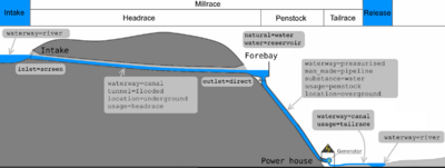
Headraces water courses are dedicated to hydropower. They lead water from intakes to forebays or penstocks.
Both canal and pressurised waterways can be used as headraces, depending of environment and water amount to carry.
A headrace waterway can go through a tunnel=flooded, be in free space or even in a man_made=pipeline. Have a look below how to tag them according to this specific usage.
It may be possible to involve water feeding infrastructure in Relation:waterway with side_stream role only if all water is took and released in the same river. It's not always the case and waterway=* graph have to be extended with or without waterway relation membership.
How to map
Don't forget to have a look at Waterways or waterway=* for more complete tagging possibilities.
These guidelines are dedicated to usage=headrace situations.
As any waterway and for power generation only, draw a line along the path followed by water. Put usage=headrace on any segment between the intake you may see in a lake or a river to any waterway with usage=penstock.
As seen in the chart at the top of this page, never directly connect the headrace waterway to a power=generator. Water should go through a penstock first, which can length a few meters to kilometers down to mountains.
Examples
| Photo | Tagging | Note |
|---|---|---|
 |
waterway=pressurised
|
Horizontal tunnels carrying water from intakes to penstocks. Such ways have a pipe flow regime, their inlet are always below the water level and no air can get inside. |
 |
waterway=canal
|
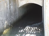
A headrace tunnel works at atmospheric pressure and water have a free surface while flowing inside. Its inlet is designed to be always above water level and air can get inside too. |
| Headrace overground canal feeding penstocks of a power plant | ||
 |
waterway=pressurised
|
The most complete case with a headrace pipeline hosted in a human accessible tunnel in operation. This is the only situation where man_made=pipeline is used in combination with tunnel=* on the same way. |
 |
On all parts, use: waterway=pressurised
operator=* On the bridge part, use:
On the underground part, use:
|
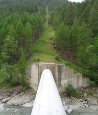
A big siphon allowing water to cross a valley. Only half side is visible on the picture, tunnels or pipelines are connecting each side at equivalent altitudes. The siphon is a pipe flow waterway. |


