Tag:waterway=weir
 |
| Description |
|---|
| A barrier built across a river to control water speed and depth. Designed to let water flow over the top all the time or at least in specific conditions. |
| Rendering in OSM Carto |
| Rendering in OSM Carto |

|
| Group: waterways |
| Used on these elements |
| Useful combination |
|
| Status: approved |
| Tools for this tag |
|
A barrier built across a river, stream or canal to regulate water levels, sometimes to divert water for industrial purposes. When water passes a weir it flows over the top, as opposed to a waterway=sluice_gate. In their most simple form a weir is a fixed structure and whether water passes a weir depends on the water level upstream of the weir. Some weirs are movable in the sense that the height of the top of the weir can be adjusted, altering both whether water passes the weir and how water reacts below the weir. In the US weirs are often called a low-head or low-rise dam. Weirs can not only be a barrier for the passing of water, but also for boats and animals using the water, see Navigation.
How to map
To map a small weir, add a node along a river and tag it waterway=weir. If the weir has a name tag it name=*.
If the weir is long enough to be mapped as a way, create a way along the length of the weir and tag it waterway=weir. Again, add a name=* if it is known. The waterway=weir should share a node with the river where they cross. Like a natural=cliff the line direction matters: On the left side there is the high side, on the right side is the lower side.
Whether a weir is height adjustable or not can be indicated by using weir:movable=*
Sometimes a fish pass or a lock=* is related with the weir, so that fish or vessels can circumvent the weir over water. When a weir or its lock are not navigable for canoeists, they may need to circumvent the lock over land (see canoe=portage).
(High-)ways over a weir
This subject was not part of the proposal but the most straightforward solution is that the highway=* and waterway=weir share a way. A section of this way may be marked with ford=yes if there is a ford.
Validators and QA tools may complain about this combination because they may have an overly generic rule saying that highways and waterways can not share a single way - this is one of the valid exceptions and tools should be fixed to accept it.
Weirs are often a barrier for users of motorboats and canoes (and thus for routing on OSM waterway-data), depending on the water level and -in the case of adjustable weirs- the height adjustment of the weir. Passing a weir can cause a lethal hazard for persons or animals because of the towback (re-circulating flow of water) on the lower side of the weir, depending on design of the weir, flowbed and the water level. In other cases weirs can be safely passed by the general public in canoes, such as on popular stretches where canoes are rented. Sometimes a special pass is build for whitewater raticants to cross safely the weir, see waterway=canoe_pass.
Examples
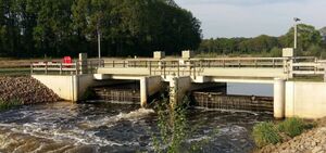
A movable (height-adjustable) weir

A (non-movable) weir navigated by canoeists
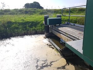
Small movable weir


Rendering
| Type | Picture | Tags | OSM Carto |
|---|---|---|---|

|
waterway=weir | 
| |
|
|
waterway=weir | 
|
See also
- waterway=dam - for a barrier that is designed for water not flowing over the top (with exception of emergency spillways).
- waterway=rapids - Rapids
- waterway=security_lock - A movable gate to control water flow
- natural=water + water=reservoir for the water impounded behind a dam.
- waterway=fish_pass - as
 natural=water + water=fish_pass - A fish pass, also known as a fish ladder, a fishway or fish steps, is a structure on or around artificial barriers (such as dams and locks) to facilitate diadromous fishes natural migration.
 - waterway=sluice_gate a movable gate to control water flow where water does not flow over the top.
- waterway=canoe_pass
Weblinks
- Weir on Wikipedia
- Diversion dam on Wikipedia