User:Ianlopez1115/Dealing with various errors
The following is an essay on tackling data-related problems and challenges faced by the OpenStreetMap Philippines community.
Introduction
Five years ago, the Philippines was mostly a blank space in OpenStreetMap. After five years, over a thousand contributors, over two million nodes and almost eighty-five thousand kilometers of highways, we are arguably one of the most active countries in this part of the world.
Because of our efforts in adding, modifying and updating OpenStreetMap data, more people are using it for navigation purposes. However, some edits are less helpful than others, and this essay tries to find out the errors, problems and challenges and provide solutions.
Errors, Problems and Challenges in a nutshell
See also Errors.
| Picture | Category | Implications |
|---|---|---|
|
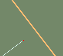
Unconnected highways (touching) | This is a severe error when looking at routing applications. Connected roads are not connected in OSM data. |
| Unconnected highway (open) | This may be a severe error when looking at routing applications. | |

|
Crossing on same layer without common node | Either bridge or tunnel and layer is missing or a common node is missing. Either reality is not reflected correctly or routing cannot be done correctly because roads are not connected in data. |
|
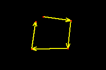
Open areas | Reality is not reflected correctly, some programs might have problems using those polygons. |
|
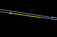
Oneway errors on dual carriageways | Routing cannot be done correctly, may cause vehicular accidents |
| Self-intersecting ways | Routing cannot be done correctly | |
|
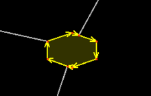
Roundabouts with wrong direction | Routing cannot be done correctly |
| Tagging for the renderer | Map looks "horrendous", routing cannot be done correctly in some cases | |
|
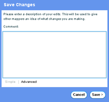
Changesets without comments | You're not giving other mappers a hint of your maping activity |
Errors, Problems and Challenges in detail
Intersecting ways without a connecting node
This particular error is often repeated by new contributors. It can be fixed through Potlatch2 by pressing the shift button while simultaneously clicking the intersecting ways.
Self-intersecting ways
This particular error is often repeated by new contributors. So, how do we fix it?
Since many new OSM contributors use Potlatch2, it is appropriate for the user to fix it using the said application. (If you know how to fix self-intersecting ways in JOSM, go here.) But first, we have to find spots that have such errors. Fortunately, we have OSM Inspector.
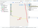
After spotting a bunch of self-intersection points (visualized in OSM Inspector as a little red X-mark), click on that mark. A selection will be shown at the right side of the page. Click on the "P" icon. It will direct you to the Editing tab. For a better view of this illustration, point your mouse towards the picture on your right.
At this point, the way with self-intersecting points will be modified. A demonstration on how to fix self-intersecting ways can be viewed at http://www.youtube.com/watch?v=5rnBHhD3HUs .
Roundabouts/traffic circles with wrong direction

This error affects routing. The Philippines is a right hand country. Thus, the traffic flow of roundabouts and traffic circles in this country is anti-clockwise (see the animated image on the right)
Tagging for the renderer
This error negatively affects the following:
- Routing/navigation services
- The various map renderers
Some errors that fall under this category are:
- Mistagging of various elements (examples below)
- Government offices tagged as
tourism=museum - Farm areas (usually rice fields) tagged as meadows
- Towns tagged as
name=[name of place] Barangay/Town/Municipal/City Hall,place=village/town/city - Drainage ditches tagged as canals
- Tagging school buildings as
amenity=public_buildingoramenity=schoolwithout the proper building tag - Double spacing in names
- Government offices tagged as
- Improper Capitalization
- Using all caps (Example:
name=RIZAL STREETfor Rizal Street)
- Using all caps (Example:
Edits that partially or do not reflect reality
This error affects routing services and may cause untoward incidents. Some examples of it are Unconnected ways and barriers not connected to a highway way.
Changesets without comments
This error negatively affects the following:
- Other mappers who want to know how their fellow mappers are doing (adding places of interest, removing edits from a tainted source, etc.)
This can be fixed by adding meaningful comments. However, adding things like "editing (name of place here)" may further confuse other mappers - it is best to be a bit more specific (Example: "Added new roads and places of interest in (name of place)")
Other things
- Take note of other users' good practices
- Some examples of good practices are following the One feature, one OSM element principle, adding insightful and helpful comments to changesets and not removing tags and features that you don't understand
- To maximize the use of Potlatch2, use the "Enhanced" map style.
TODO
![]() Add/improve explanation
Add/improve explanation
![]() Add pics to illustrate
Add pics to illustrate
![]() Change to a less contentious title (if needed)
Change to a less contentious title (if needed)