Zh-hant:Featured images/Jul-Sep 2018
Jump to navigation
Jump to search


這是特色圖片,展現開放街圖畫地圖範例,以及最能代表開放街圖的專案。
如果你知道其他有類似品質的圖片,你可以在特色圖片提名處(en)提名。
| ← 從2017年7月到9月 | ← 從2018年4月到6月 | 從2018年10月到12月 → | 從2019年7月到9月 → |
特色圖片庫、從2018年7月到9月

2018年、第27週
2018年、第28週

2018年、第29週

2018年、第30週

2018年、第31週

2018年、第32週
2018年、第33週
2018年、第34週
2018年、第35週
2018年、第36週
2018年、第37週

2018年、第38週
2018年、第39週
細節和字幕
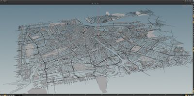
第27週(從2018年7月2日星期一到2018年7月8日星期日) [Edit]
- English : 3D rendering of Amsterdam by Paleo Pixels, who developed converter scripts to load OpenStreetMap data into the “Houdini” 3D software.
- 中文(繁體) : Paleo Pixels 製作的 3D 渲染的阿姆斯特丹地圖,他開發了轉換腳本來載入開放街圖資料到 “Houdini” 3D 軟體。
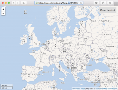
第28週(從2018年7月9日星期一到2018年7月15日星期日) [Edit]

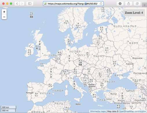
- English : The Wikimedia Foundation recently announced new support for internationalized map renderings. E.g. showing European place names in Japanese.
- 中文(繁體) : 維基媒體基金會最近宣佈新支援國際化地圖渲染。例如歐洲一帶顯示日文名稱。
第29週(從2018年7月16日星期一到2018年7月22日星期日) [Edit]

- English : Arjan Schrauwen from Dutch graphics design firm Beeldkompaan has taken a chunk of New York OpenStreetMap buildings data to a new moonbase location.
- 中文(繁體) : 荷蘭視覺設計公司 Beeldkompaan 的 Arjan Schrauwen 運用大量的紐約開放街圖建築資料,放到新的月球基地位置上面。
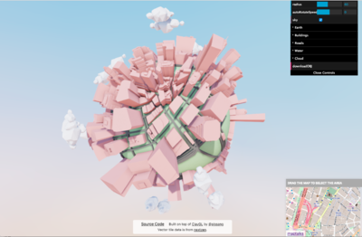
第30週(從2018年7月23日星期一到2018年7月29日星期日) [Edit]

- English : Little Big City, “Generating city on a little planet on the web”: a project by Yi Shen, using OpenStreetMap data via Nextzen vector tiles.
- 中文(繁體) : 小小大城市,"在網路上的小小星球上生成城市":Yi Shen 製作的專案採用由開放街圖資料產生的 Nextzen 向量圖磚。
第31週(從2018年7月30日星期一到2018年8月5日星期日) [Edit]

- English : State of the Map 2018, the international OpenStreetMap conference, was held in Milan, Italy.
- 中文(繁體) : 在義大利米蘭舉行的國際開放街圖大會 State of the Map 2018。
第32週(從2018年8月6日星期一到2018年8月12日星期日) [Edit]

- English : Miriam Gonzales and Céline Jacquin, from the Mexican OpenStreetMap community, were interviewed by the TV UNAM (the TV channel of the main Mexico university). They talked about OSM, GeoChicas and humanitarian mapping.
- 中文(繁體) : 來自墨西哥開放街圖社群的 Miriam Gonzales 和 Céline Jacquin,被 TV UNAM (墨西哥大學的主要電視頻道)訪問,談論有關 OSM、GeoChicas 和人道救援畫地圖。
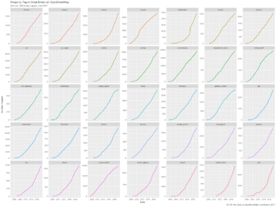
第33週(從2018年8月13日星期一到2018年8月19日星期日) [Edit]

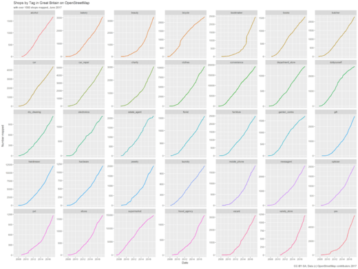
- English : "Accumulation curves" showing the growth of shops data in the UK by SK53. This image shows a graph for each of the top shop types while his recent blog post compares and analyses growth shapes in various other ways.
- 中文(繁體) : SK53 製作的"累積曲線圖"顯示英國商店資料成長情形,這張圖有每種類型商店的圖形,以及在他最近的部落格文用不同方法比較和分析成長形狀。
第34週(從2018年8月20日星期一到2018年8月26日星期日) [Edit]

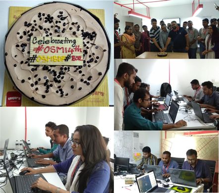
- English : Celebrations of the OpenStreetMap 14th Birthday, and a mapathon taking place in Dhaka, Bangladesh.
- 中文(繁體) : 孟加拉達卡的圖客趴上面,慶祝開放街圖 14 歲生日!
第35週(從2018年8月27日星期一到2018年9月2日星期日) [Edit]

- English : OSM Inspector lets you find broken multipolygons now that the default map layer is less tolerant of rendering them.
- 中文(繁體) : OSM Inspector 讓你找到壞掉的多重多邊形,如今預設的地圖圖層不太容忍渲染它們
第36週(從2018年9月3日星期一到2018年9月9日星期日) [Edit]

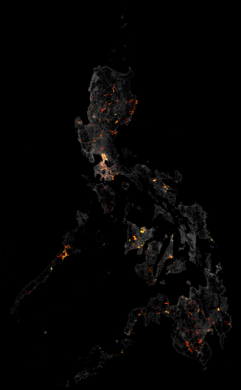
- English : A visualisation of the increase in the node density in the Philippines from April to the end of June 2018
- 中文(繁體) : 從 2018 年 4 月到 6 月底時,視覺化菲律賓的節點密度增加層度
第37週(從2018年9月10日星期一到2018年9月16日星期日) [Edit]

- English : The OSM-for-the-dyslexic project (osm4dys.org) is creating apps and map styles for use by dyslexic people.
- 中文(繁體) : OSM-for-the-dyslexic 專案 (osm4dys.org) 撰寫 app 和地圖樣式給誦讀困難的人使用。
第38週(從2018年9月17日星期一到2018年9月23日星期日) [Edit]

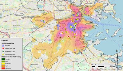
- English : Public health researcher John F. Pearson created this map for a Public Health Post article, showing open data on discarded needle collections in Boston, Massachusetts, presented on an OpenStreetMap base map.
- 中文(繁體) : 公衛研究者 John F. Pearson 為了Public Health Post 專欄創造這個地圖,用開放資料呈現波士頓丟棄的針頭集合,並且在開放街圖的底圖上呈現。
第39週(從2018年9月24日星期一到2018年9月30日星期日) [Edit]

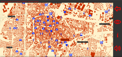
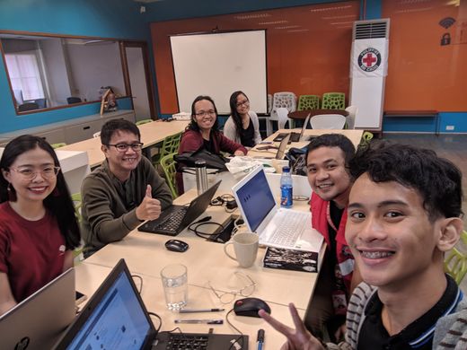
- English : The community engaged in disaster preparedness/response mapping for Typhoon Ompong in the Philippines, including this mapathon event hosted by the Red Cross.
- 中文(繁體) : 菲律賓社群為了山竹颱風來襲所做的災難事前準備與災難回應的繪圖行動,包括在這次紅十字會主辦的圖客趴裡。