Australian Mapping Community/Past Events/Kangaroo Island Mapping Party
Jump to navigation
Jump to search
Three OSMers met up on Kangaroo Island, South Australia, Australia on 4th October 08 and cycled around until 11th October 08. The ride was actually a BikeSA Annual Tour [1] so we were well fed and happy on the job. The sealed roads had been completed by previous visiting mappers so we concentrated on the road names, streets in the towns and POIs, as well as cycling a number of dirt roads. Each rider cycled about 600km.
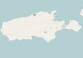
The before map

One month later
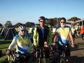
drlizau, swamp and rrankin at Kingscote ready for the last days mapping assisted by Paddy


