Australia/Archive/Data.australia.gov.au/Queensland
| This page is out of date. The information here was correct before the 2012 licence change but is no longer applicable. Before importing any data please read the import guidelines and tell other mappers what you are planning to do via the talk-au mail list. |
There are Queensland Government-sourced datasets available from http://data.australia.gov.au/.
morb_au is currently playing around with them.
Morb_au has also converted some of the datasets to the WMS delivery format for the convenience of fellow openstreetmappers.
Legal Usage
Morb_au has received advice in September 2009 from the Department of Environment and Resource Management regarding the appropriate use of the Queensland datasets. The basic rules are as follows:
The datasets are released under CC-BY. Since "BY" means an attribution must be declared, the attribution text for derived data must include: "State of Queensland (Department of Environment and Resource Management) 2009".
Dataset Details
Property Boundaries Annual Extract Queensland (Lite DCDB)
- Original dataset home page: http://data.australia.gov.au/152
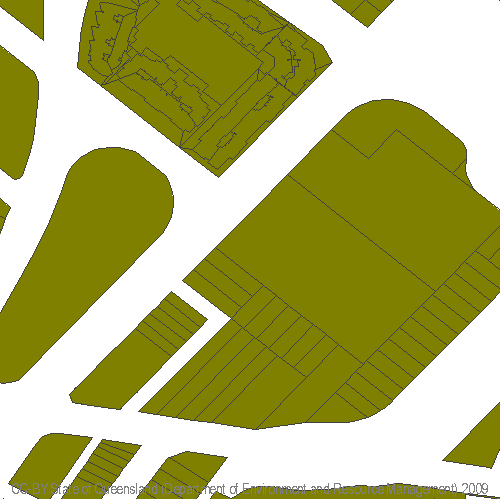
The Digital Cadastre DataBase (DCDB) is the spatial representation of the property boundaries and the related property descriptions of Queensland (Lot on Plan). The DCDB provides the map base for systems dealing with land and land related information and provides data in order to generate hard copy map products. This polygon layer is a subset of the complete DCDB, indicating only properties and showing minimal attribute data about the properties.
Note that while some metadata ambiguously refers to this product having a fortnightly update cycle, it actually appears to be just the one single extract from earlier in 2009.
For background information on the Queensland surveying standards (and therefore the accuracy of the DCDB geometry), a good place to start is: http://www.nrw.qld.gov.au/property/surveying/technical_standards.html
Value to OpenStreetMap
Can be used to derive median (centreline) way geography.
Hosted WMS Copy details
User morb_au has taken the original ESRI Shapefile set, and converted the geometry component to a WMS hosting service. Note this is a "toy" server and the address is subject to change/fail at little to no notice.
Simply copy and paste one of these URLs to get started as a WMS client:
- Generic WMS URL (e.g. QGIS):
- http://206.123.75.6/cgi/ms/mapserv?map=../../mapserv/wms.osm.au.qld.map& then select the dcdb_lite_geometry layer
- Merkaartor TMS (Tile Map Server) servers URL:
- Server address: 206.123.75.6
- Path: /cgi/ms/mapserv?layers=dcdb_lite_geometry&srs=EPSG:4326&format=image/png&map=../../mapserv/wms.osm.au.qld.map&mode=tile&tilemode=gmap&tile=%2+%3+%1
- Tile size: 256
- JOSM WMS URL:
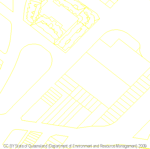
- http://206.123.75.6/cgi/ms/mapserv?service=WMS&version=1.1.1&request=GetMap&layers=dcdb_lite_geometry_outline&srs=EPSG:4326&format=image/png&map=../../mapserv/wms.osm.au.qld.map& (outlines only, useful when transposing against aerial imagery)
An example location to browse is latitude -27.5, longitude +153.0.
Limited to 1:10000 scale (at approx 72DPI, or about a 300 m scale bar in JOSM).
To "ping" the WMS Server to see if it's operating at all, try this example URL in your web browser (not WMS client): http://206.123.75.6/cgi/ms/mapserv?service=WMS&version=1.1.1&request=GetMap&layers=dcdb_lite_geometry&srs=EPSG:4326&format=image/png&map=../../mapserv/wms.osm.au.qld.map&bbox=153.0314632,-27.4624401,153.0345478,-27.4593555&width=500&height=499 - Here's one we prepared earlier:
or http://206.123.75.6/cgi/ms/mapserv?service=WMS&version=1.1.1&request=GetMap&layers=dcdb_lite_geometry_outline&srs=EPSG:4326&format=image/png&map=../../mapserv/wms.osm.au.qld.map&bbox=153.0314632,-27.4624401,153.0345478,-27.4593555&width=500&height=499 - Here's one we prepared earlier:
Hosting Your Own Mapserver for DCDB QLD Lite
Mapnik Rendered Version
There is a demonstration Mapnik overlay available at http://58.96.53.60/~b/dcdb.html which is handy for editing with potlatch. This is a temporary server and could go away at any time.
Tagging Examples
By way of example, morb_au is currently setting the following keys on all OSM data copied or traced from the DCDB Lite layer. He is placing them here so he can use these canned responses no matter which editor he's using.
for all items
- attribution=Based on data from State of Queensland (Department of Environment and Resource Management) 2009
This one is important: the conditions of the CC-BY stipulate we at least include the phrase "State of Queensland (Department of Environment and Resource Management) 2009". According to advice received by morb_au from DERM in early October 2009, the citation of "Queensland Department of Environment and Resource Management" shown in the data.australia.gov.au website at that time is actually incorrect.
- source=au.qld.dcdb_lite
(morb_au welcomes advice on if this is an appropriately formatted source tag. Note the namespace implies the responsible authority for the dataset, not necessarily where it was downloaded from.)
for roads and paths
- highway=road (or service or footway ... these usually show out according to the width of the right of way)
- note=FIXME: DCDB indicates a right of way in this location. Needs a field survey to confirm highway type and actual alignment.
for railways
- railway=rail
- note=FIXME: DCDB indicates a railway in this location. Needs a field survey to confirm railway type and actual alignment.
for land use areas
- landuse=residential
- note=FIXME: Add streets in this residential area.
Note of course that even though a right of way is shown in the DCDB, doesn't mean that an actual street or road has been built over it. Especially in rural areas it's just a bit of land in its natural state, especially if there's other rights of way servicing the same properties. This version of the DCDB also doesn't show names.
Therefore there is great value in still physically surveying an area if you happen to be in the neighbourhood; for example you can collect names and survey exact alignments. Anyone who's visited a typical modern housing estate will know that the road alignment is usually quite different to the medial alignment implied by the DCDB.
Local Government Boundaries Annual Extract Queensland
- Original dataset home page: http://data.australia.gov.au/157
The spatial representation of the Local Government areas of Queensland.
Value to OpenStreetMap
Can be used to derive boundary ways at admin_level=6.
Surface Water Gauging Stations Queensland
- Original dataset home page: http://data.australia.gov.au/148
A point coverage depicting the location of the current gauging stations network in Queensland.
Value to OpenStreetMap
Not sure at the moment.
Groundwater Observation Bore Sites
- Original dataset home page: http://data.australia.gov.au/142
Existing sub-artesian observation bores owned or managed by the Queensland Department of Natural Resource that comprise the Groundwater Monitoring Network. The bores in the network are monitored on a regular and scheduled basis.
Value to OpenStreetMap
Not sure at the moment.
Drainage Basins Queensland
- Original dataset home page: http://data.australia.gov.au/134
The boundaries and names of the Queensland Drainage Basins are as defined by the Australian Water Resources Management Committee (WRMC). Information includes the name and number of each drainage basin. The capture scale for this dataset is 1:100 000.
Value to OpenStreetMap
Not sure at the moment.
Queensland Wetlands Mapping – Estates Layer including National Parks, Conservation Areas & Forest Reserves
- Original dataset home page: http://data.australia.gov.au/127 - James Livingston is importing these from July 2010
Value to OpenStreetMap
Can import into OpenStreetMap as equivalent landuse areas.
Queensland Wetlands Data – Wetlands
- Original dataset home page: http://data.australia.gov.au/119
Mapping of water bodies and wetland regional ecosystems at 1:100,000 scale across Queensland.
See Data.australia.gov.au/Queensland/Wetlands for more detail
Value to OpenStreetMap
Can import into OpenStreetMap as equivalent landuse areas.
Queensland Wetlands Mapping – Streams
- Original dataset home page: http://data.australia.gov.au/97 or http://data.australia.gov.au/114
This dataset provides mapping of water bodies and wetland regional ecosystems at 1:100,000 scale across Queensland.
NOTE: As of 10 October 2009, this dataset download appears to be defective. There is no shapefile in the Zip archive.
See Data.australia.gov.au/Queensland/Wetlands for more detail
Value to OpenStreetMap
Can import into OpenStreetMap as equivalent waterway ways.
Other known Queensland Datasets not yet under CC-BY
The following datasets are known to be available for the Queensland region but are not yet known to be under an OSM-compatible licence. They are listed by the presumed copyright owner, so we know who to lobby:
Get inspiration here: http://asdd.ga.gov.au/
State of Queensland
Get inspiration here: http://www.nrw.qld.gov.au/services_resources/category.php?class_id=8 http://dds.information.qld.gov.au/DDS/
Commonwealth of Australia
Get inspiration here: http://www.ga.gov.au/resources/find-products/browse-products.jsp
Private Organisations
None known yet - enter your own if you think it would be of value to OSM


