Cape Town mapping party - September 2009
OSM South Africa has been growing explosively and it's time for the next Cape Town Mapping Party.
When
Sunday 20th September 2009
Time: 10:00 - 15:00
Venue
Greens Restaurant in Plattekloof. Location Map
Address
Shop 8, Plattekloof Village Centre
Cnr Plattekloof & Olienhout Drive
Plattekloof
7500
Tel:021 558 0855
email:
Directions
Travelling on the N1 from Cape Town towards Parow. At the Parow/Plattekloof offramp, turn left onto Plattekloof Rd (M14). Follow Plattekloof Rd to the 2nd set of robots & turn right into Baroncety Boulavard . You'll find the Plattekloof Village Shopping Centre on the right hand side 100m up from the corner. GREENS is to your left as you enter the carpark.
OSM Map
Order of Activities
- Briefing on the aims of the days activity
- Collection of data
- Meeting at a central point to edit and upload
- A tutorial on using potlatch and/or josm
- Lunch and refreshments
What to bring
- Yourself and a friend
- GPS receiver - capable of logging detailed tracks (not required, few spare)
- Notepad and pen/pencils for taking notes
- Laptop - for editing and uploading data (helps, but not required)
- Camera (helps, but not required)
Interested Attendees
If you are interested in attending, please leave your name below:
- Brendan Barrett - can bring car, laptop, HSDPA enabled wi-fi access point.
- Trevor Hughes - will bring 2xGPSr, 2xlaptop, car
- Trevor Bartleet
- Lance Burger - GPS, laptop, car
MJ Watson- I may not be able to make it but I don't know yet (but rather assume I can't).- Ian Mc Shane
- Eduard Gree (may be away until 20 September)
- Adrian Frith - can bring GPS, laptop and car.
Add your name here
Follow Up
The weekend was quite a success. OSM has been on it's feet for some time now in South Africa, and this was a good opportunity for the local Cape Town mappers to meet.
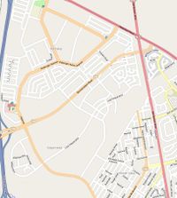
Before
There are large unmapped areas, and no parks or POIs.
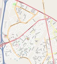
After
All the roads are now mapped. There area still some street names outstanding, and the area would benefit from some more POI's. This should be light work for a casual mapper passing through the area with a camera.
Party Render
The part render can be found at the YouTube link below http://www.youtube.com/watch?v=Xpc6dU5rFV4

