Mapillary/Data collection with Mapillary
Data collection

- Capturing photos with an Android phone


The application for data collection is virtually the same in Android or iPhone. However, due to Android supporting background services it is possible to automatically send your photos whenever a network WiFi is connected without the user actively caring about it. You can also view and share Mapillary places from within the app.
The data collection can also be made using a traditional camera (without a GPS chip), but will need to correlate photos location manually using a GPS track.
Capturing modes
- Walking (hiking) - manual and sequence capturing; ideal for a foot walks, hikes and strolls.
- Try to collect photos that overlap.
- Try to capture the change of direction in overlapping frames while rotating around your axis slowly.
- For best quality pictures and gps position, hold device in front of you, frame shot, keep camera level, minimize shake.
- Longer duration walks (or cold weather) will require the device to be mounted to yourself e.g. jacket or rucksack harness. Ensure that the device is both secure (small plastic hair clips are useful) and level before starting to map. Discrete mounting is recommended while mapping in city or other heavily populated areas to avoid unwelcome attention.
- Riding (bike / car) - shots every 2 seconds.
- Point the camera at the location in which you are going. Great for use with bike!
- If you are driving, make sure that panels, columns, etc. are not in view on the camera.
- Panorama - when standing in one place, you want to capture views from all directions.
- Suitable for use in front of monuments, interesting buildings, at junctions or in a place that stands for beauty.
- Stand absolutely still at the same point while performing all catches of a "panorama".
- Be sure to take several overlapping pictures in sequence.
In either mode, taking pictures in phone landscape orientation (horizontal) is recommended in order to have a nice stitching experience. And remember: the capture mode selected will determine how the photos are processed, which rules and approaches are applied, improving the final result, especially the intelligent navigation. Using a smartphone connected to the Internet, it is also possible you know the photos that already exist to a certain place.
Preparing to Capture Images
- Short (less than 30 mins)
- No special preparation required.
- Images will consume storage, so ensure you have enough free space on your device. An image taken on an Iphone5 will consume about 2 MB. In riding mode (2 sec), in 30 minutes, you will take about 900 pictures, about 1.8 GB.
- Medium (30 - 60 mins)
- Consider deleting any unused apps, backup then delete old photos and videos, minimize music.
- Close all non-required apps or restart the device. This will minimize the chances that another app will interrupt the mapping session. On IOS double click the home key and swipe up to close apps.
- Images will consume storage, so ensure you have enough free space on your device. An image taken on an Iphone5 will consume about 2 MB. In riding mode (2 sec), in 60 minutes, you will take about 1800 pictures, about 3.6 GB.
- If outdoors, use an ear piece. This gives you the confidence (with the shutter click) that pictures are being taken. It is possible to listen to music (or your favorite radio station via app) while mapping.
- Attach an external power supply, Depending on the health of your device battery, without an external source, you may have nothing or very little left at the end of a 60 minute session.
- Most devices will automatically backup to the cloud. Mostly this is not required for Mapillary pictures, so you should deactivate this app from backups (in IOS go to system settings > icloud > storage > your iphone > show all apps).
- Long (longer than 60 mins)
- If you receive regular calls, consider an alternative to put your sim card while mapping.
- Consider carrying a download device (laptop) in order to extend mapping range. A typical 16 GB Iphone5, with only bare minimum apps and other files will not allow more than 5500 pictures (3 hours).
- Consider carrying an external GPS (or car satnav) if traveling in new areas. This will allow you to plan your route and ensure you do not get lost.
Image processing (traditional cameras only)
In order to store location information directly in your photos (in EXIF metadata), you can use JOSM (see Photomapping In JOSM#Arranging photos on a GPS trace).
If your camera time is not synchronized (and not adjustable), you can edit photo timestamps with this procedure (under Linux, with jhead and exiftool) :
- jhead -da2015:02:14/15:30-2014:08:18/01:41 *
- This command changes the photo time stamp, the syntax for the date is newdate-olddate.
- jhead -ft *
- This command copies the new photo time stamp from EXIF meta-data into file meta-data
- In JOSM, do the GPS correlation
- exiftool -Orientation=1 -overwrite_original -n *
- This command create an empty field for photo orientation in EXIF meta-data.
Editing content


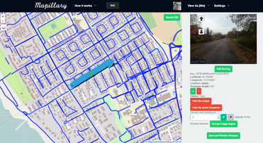
Any logged-in user can edit all public content. The basic actions are
- Correct lon/lat
- Correct compass direction of images or all images in a sequence
- Edit location info
- Hide images or whole sequences
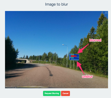
- Request [1]blurring or un-blurring for parts of images
All changes are approved by the Mapillary team before being applied.