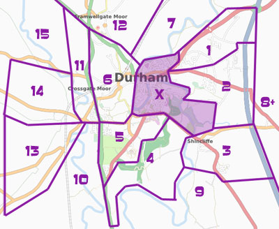
Durham Mapping Party 2008
I've been mapping quite a bit of Durham, now lots of people are interested and I'd like some help.
Date: Saturday 7th and Sunday 8th June 2008 (after exams, before uni ends, when it's sunny). Please sign your name at the bottom if your interested or coming!
Full details are at: http://www.livingwithdragons.com/party.
There will be a Bar Garden Festival outside!!!
Where
Thanks to St Cuthbert's Society we will be meeting in their JCR on the Bailey (centre of Durham).
St Cuthbert's Society JCR, 12 South Bailey, Durham, DH1 3EE. Co-ordinates: 54.7708, -1.5774
How to get there
From the Railway Station walk out alongside the road until you can cross over a blue footbridge.
- Off the big roundabout is North Road with all the shops.
- Walk past the bus station and then cross over Framwellgate Bridge (by 'The Gates').
- Rather than walk up Silver Street, turn right down the steps next to Bella Italia and follow the riverside path until you get to Prebends Bridge.
- St Cuthbert's Society is the big white building at the end of the road.
The Station-Cathedral Bus is 50p for the day and will get you as far as Palace Green.
By Car it can be difficult to park in the centre.
- Getting onto the Bailey/Peninsula is only from the A690 through the Market Square, and it costs £2 (congestion charge) to leave on Saturday between 10am and 4pm.
- It varies how much the Place Green car park charges but you may be lucky with roadside parking on The Bailey.
- Just before entering the Market Square is Prince Bishops car park, this is about £3 for 4 hours.
- There are about 8 parking spaces at Pimlico Dip, the other side of Prebends Bridge. The metre is 30p per half hour.
- Finally you could park in one of Durham's Park & Ride car parks. All the busses should take you to Milburngate (near the Market Square).
- The Howlands Park & Ride (South) might stop by The New Inn and you can walk along the riverside path to Prebends Bridge.
What you need
Nothing at all, Blackadder is bringing OSM gps units to lend out for the day(no cost, an id card required as a deposit). However if you have any of the following things, you could bring it along:
- mode of transport (foot is standard, bicycle/rollerblades work well, a car will have some advatages, horses may of been used before)
- note material (paper & pen, or similar), you may want a clipboard too
- a camera or audio, the timestamp it was taken can probably be matched up with the gps record to see where you were(photograph the names of roads)
- a gps receiver would of course be good if you have one
- laptop if you want, we can use our traces & upload to the map at the end of the day, install josm if you can
The Plan
- We meet in Durham
- The city has been divided up (see cake above), you pick an area you fancy (I should know sections best for different transports, or where you want to sightsee)
- You go out mapping your section (after a few mintues learning what to do, if needed)
- After a few hours we meet back for lunch, some skip this and have other lunch plans
- 2-3 hours more and we meet back at a place selling cool beverages
- there we exchange stories, look at the gps tracks to see who got lost or who was following someone
- repeat the following day
Travel/Accomodation
To get to Durham City there are fairly fast trains on the London Kings Cross - Eingburgh line (National Express East Coast) and they even have free wifi for all passengers now. Their website, [1] is actually very good for finding the chepest tickets (better than thetrainline anyway).
If you're needing to stay over then the big places in the centre I know of are the Travel Lodge by Gilesgate roundabout, the new Premier Inn in the sands/walkergate area, or more luxury the Marriot Hotel on Old Elvet. You could also search the web to find little B&Bs. A lot of the colleges rent rooms but it's in term time so I don't know if they will do.
Geocaching
I suggested on my blog combining mapping with geocaching. If you'd like to find a geocache half way through mapping please let me know so I hide enough. Also tell me how you'll be moving on the mapping (walking or cycling is most common) as some areas will be better suited for mapping in such ways.
Links
Mainly from my Living with Dragons blog, but ones about the party. (latest first)
Who's Interested/Coming?
Please sign your name below (use ~~~ to sign your wiki username). Having an idea of attendence will be great for my organisation/motivation, and maybe getting someone to sponsor some lunch for us all. Also good to say is how you may be mapping (foot, cycle,...?) and equipment your going to bring.
- LastGrape(Gregory) will be organising and so there both days.
- user:nickb
- User:Steve
- User:gerv definitely
- User:louisa_parry - will see if I can get up there for the Saturday
- User:Nrms - hopefully both days... Depends on other committments
- Blackadder - Both days. Is bringing up GPS units and banner.
- you?
