ES:OpenOrienteeringMap

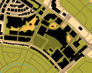
OpenOrienteeringMap (oomap.co.uk/) is a custom Mapnik rendering of worldwide OSM data (most of it) loosely using the orienteering map specifications (see Wikipedia article or IOFmapping on this wiki) defined ISOM (with a few features borrowed from ISSOM). This rendering is created by Oliver O'Brien.
There are two styles: One is the Street-O and the other is Pseud-O. The Street-O style shows mostly roads and footways in a map style often used in urban orienteering. The Pseud-O style is a "less serious map" that mimics depiction of most features of normal orienteering maps.
The rendering is done on-the-fly, but with caching. The two styles are available from zoom levels 12 to 18. Levels 15 & 16 roughly correspond to scales that would be used for conventional orienteering.
Planned future enhancements
- Automated update of the underlying database with the daily/weekly planet diffs.
- Contour lines from SRTM - preferably smoothed/cleaned like in OCM. Ideally these would be layered under line features, but for simplicity will probably be overlaid on the top as an additional semi-transparent layer.
- Include an pseudo-ISSOM style. The main differences will be that buildings are shown in grey (rather than black), and paved paths, such as cycleways, are shown as small roads (brown with black lines)