File:Br-classificacao-igrejinha-rs-plano-diretor.jpg
Jump to navigation
Jump to search
Size of this preview: 416 × 600 pixels. Other resolutions: 166 × 240 pixels | 333 × 480 pixels | 533 × 768 pixels | 1,024 × 1,476 pixels.
Original file (1,024 × 1,476 pixels, file size: 298 KB, MIME type: image/jpeg)
Summary
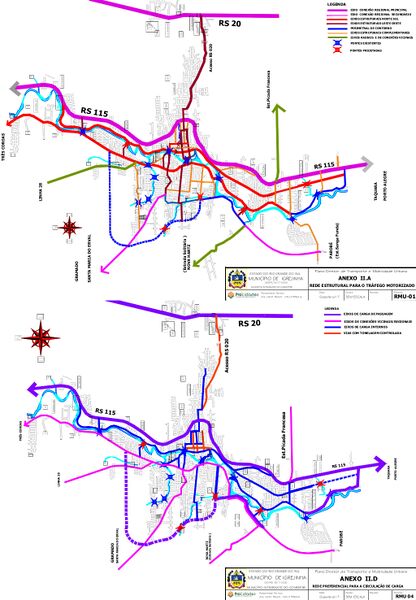
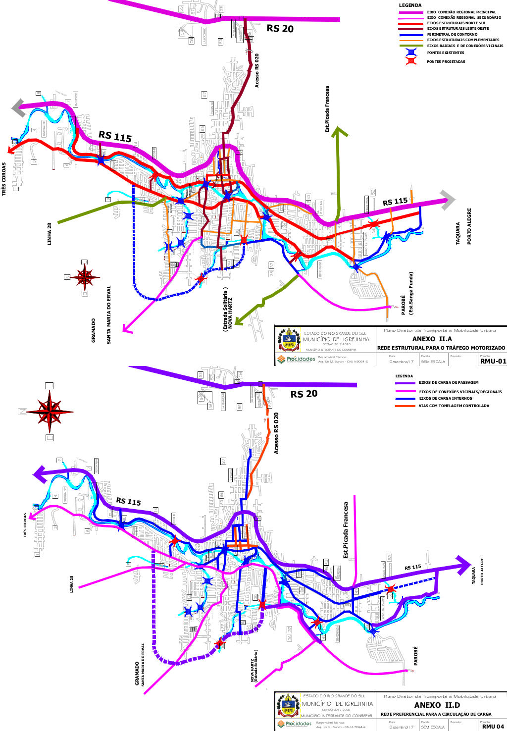
Classificação oficial segundo o plano de mobilidade, publicada em 17 de maio de 2018.
Disponível oficialmente no site da Prefeitura em Geoprocessamento, cartografia digital e mapas > Dados para download - Mapas e documentos diversos em PDF em:
- PlanMob Anexo IIA
- PlanMob Anexo IID
Licensing
![]()
This file has been released into the public domain by the copyright holder, its copyright has expired, or it is ineligible for copyright. This applies worldwide.
Please, please use more specific template such as {{PD-self}} / {{PD-creator}} / {{PD-shape}} / {{PD-USGov}} / {{PD-old}} / {{PD-RU-exempt}} ... This template is not making clear why this work is in the public domain.
Please, please use more specific template such as {{PD-self}} / {{PD-creator}} / {{PD-shape}} / {{PD-USGov}} / {{PD-old}} / {{PD-RU-exempt}} ... This template is not making clear why this work is in the public domain.
File history
Click on a date/time to view the file as it appeared at that time.
| Date/Time | Thumbnail | Dimensions | User | Comment | |
|---|---|---|---|---|---|
| current | 21:57, 11 January 2021 | | 1,024 × 1,476 (298 KB) | Ftrebien (talk | contribs) | Classificação oficial segundo o plano de mobilidade, publicada em 17 de maio de 2018. Disponível oficialmente no site da [https://www.igrejinha.rs.gov.br/ Prefeitura] em [https://www.igrejinha.rs.gov.br/p.asp?i=384 Geoprocessamento, cartografia digital e mapas] > [https://drive.google.com/drive/u/1/folders/1_iKdob9FlQSevBLsmzCRlUOMtIhP66UA Dados para download - Mapas e documentos diversos em PDF] em: * PlanMob Anexo IIA * PlanMob Anexo IID |
You cannot overwrite this file.
File usage
The following page uses this file: