File:Br-porto-alegre-rs-plano-cicloviario.png
Jump to navigation
Jump to search

Size of this preview: 391 × 599 pixels. Other resolutions: 156 × 240 pixels | 313 × 480 pixels | 501 × 768 pixels | 1,024 × 1,570 pixels.
Original file (1,024 × 1,570 pixels, file size: 346 KB, MIME type: image/png)
Summary
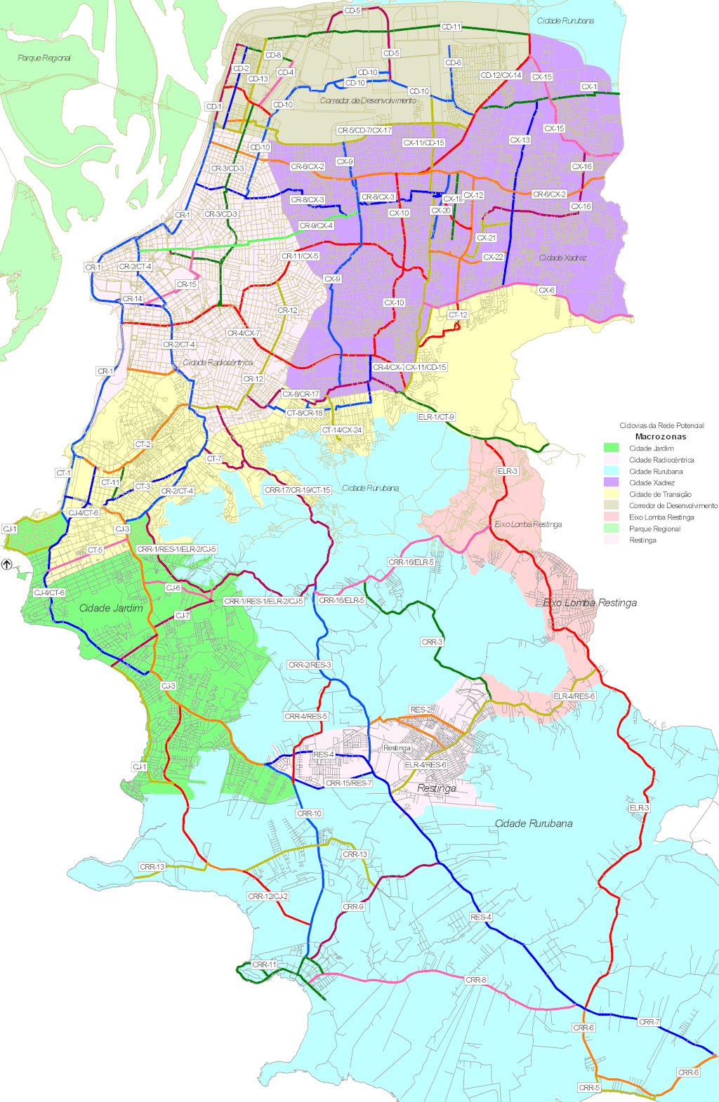
Plano cicloviário publicado em 9 de setembro de 2008.
Disponível oficialmente no site da Prefeitura neste link direto.
Licensing
![]()
This file has been released into the public domain by the copyright holder, its copyright has expired, or it is ineligible for copyright. This applies worldwide.
Please, please use more specific template such as {{PD-self}} / {{PD-creator}} / {{PD-shape}} / {{PD-USGov}} / {{PD-old}} / {{PD-RU-exempt}} ... This template is not making clear why this work is in the public domain.
Please, please use more specific template such as {{PD-self}} / {{PD-creator}} / {{PD-shape}} / {{PD-USGov}} / {{PD-old}} / {{PD-RU-exempt}} ... This template is not making clear why this work is in the public domain.
File history
Click on a date/time to view the file as it appeared at that time.
| Date/Time | Thumbnail | Dimensions | User | Comment | |
|---|---|---|---|---|---|
| current | 18:39, 13 June 2024 | | 1,024 × 1,570 (346 KB) | Ftrebien (talk | contribs) | Plano cicloviário publicado em 9 de setembro de 2008. Disponível oficialmente no site da [https://www.saolourencodosul.rs.gov.br/ Prefeitura] [http://lproweb.procempa.com.br/pmpa/prefpoa/eptc/usu_doc/pdci_relatorio_final.pdf neste link direto]. |
You cannot overwrite this file.
File usage
The following page uses this file: