File:EQ-2022-000232-AFG-media-02.png
Jump to navigation
Jump to search

Size of this preview: 800 × 566 pixels. Other resolutions: 320 × 226 pixels | 640 × 453 pixels | 1,024 × 724 pixels | 1,280 × 905 pixels | 2,560 × 1,810 pixels | 4,960 × 3,507 pixels.
Original file (4,960 × 3,507 pixels, file size: 29.76 MB, MIME type: image/png)
Summary
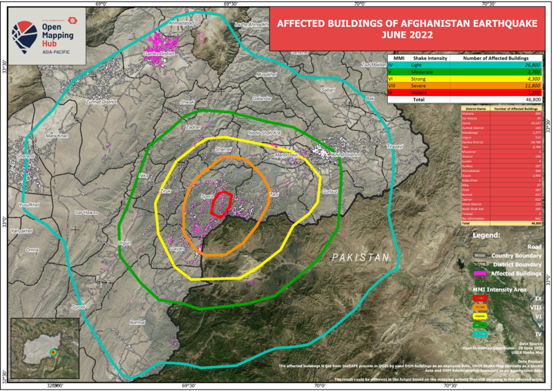
| Description | Image showing the affected South of Khost in Afghanistan. The analysis was done using InaSAFE |
|---|---|
| Author | Harry Mahardhika |
| Source | AP HUB |
| Date | June 2022 |
![]()
This media file does not have sufficient information on its copyright status. If you have created this file yourself, or the file is available under some open licence allowing its use on OSM Wiki or the file is in the public domain, you can edit the file description page to license it under one of the allowed licences. If you did not create it and it is not in the public domain, you must ask the copyright holder for permission to release it under one of the allowed licenses. Wiki:Media file license chart may be helpful to find a suitable licence.
Files without licences marked with this template are listed in Category:Media without a license or one of its subcategories. If the file is without a known open licence: ask its uploader to clarify situation or find a replacement and mark this file with {{Superseded by Commons}} and replace its uses.
Files without licences marked with this template are listed in Category:Media without a license or one of its subcategories. If the file is without a known open licence: ask its uploader to clarify situation or find a replacement and mark this file with {{Superseded by Commons}} and replace its uses.
If uploader was notified this month: use {{No licence|subcategory=uploader notified 2024, June}} - to put media into Category:Media without a license - uploader notified 2024, June and mark image as one where uploader was notified.
| Contains map data © OpenStreetMap contributors, made available under the terms of the Open Database License (ODbL).
The ODbL does not require any particular license for maps produced from ODbL data, produced maps may be subject also to other licences. |
File history
Click on a date/time to view the file as it appeared at that time.
| Date/Time | Thumbnail | Dimensions | User | Comment | |
|---|---|---|---|---|---|
| current | 13:48, 10 August 2022 | | 4,960 × 3,507 (29.76 MB) | Claurt07 (talk | contribs) | {{Information | description= Image showing the affected South of Khost in Afghanistan. The analysis was done using InaSAFE | source= AP HUB | date= June 2022 | author= Harry Mahardhika | permission= | other_versions= }} |
You cannot overwrite this file.
File usage
The following page uses this file: