File:Hasenheide Suedseite Orthophoto.png
Jump to navigation
Jump to search


Size of this preview: 800 × 291 pixels. Other resolutions: 320 × 116 pixels | 640 × 233 pixels | 1,434 × 521 pixels.
Original file (1,434 × 521 pixels, file size: 669 KB, MIME type: image/png)
Summary
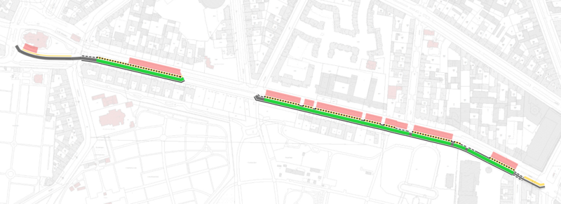
Visualisierung von Radwegeigenschaften der Protected Bike Lane Hasenheide (Untergrundlayer: Geoportal Berlin / Berlin Zoom).
Licensing
![]()
![]()
![]()
This work is licensed under the Creative Commons Attribution-ShareAlike 4.0 License.
Attribution not specified as a parameter! THIS LICENSE ALWAYS REQUIRES ATTRIBUTION! Use {{CC-BY-SA-4.0|Attribution, typically name of author}} See Template:CC-BY-SA-4.0 for full description this template should be used.
Attribution not specified as a parameter! THIS LICENSE ALWAYS REQUIRES ATTRIBUTION! Use {{CC-BY-SA-4.0|Attribution, typically name of author}} See Template:CC-BY-SA-4.0 for full description this template should be used.
File history
Click on a date/time to view the file as it appeared at that time.
| Date/Time | Thumbnail | Dimensions | User | Comment | |
|---|---|---|---|---|---|
| current | 01:00, 6 January 2020 | 1,434 × 521 (669 KB) | Supaplex030 (talk | contribs) | Visualisierung von Radwegeigenschaften der Protected Bike Lane Hasenheide (Untergrundlayer: Geoportal Berlin / Berlin Zoom). |
You cannot overwrite this file.
File usage
The following 2 pages use this file: