File:Hilpoltstein-Stadtspiegel-Ausschnitt-2015-10.png
Jump to navigation
Jump to search

Size of this preview: 423 × 599 pixels. Other resolutions: 169 × 240 pixels | 339 × 480 pixels | 826 × 1,169 pixels.
Original file (826 × 1,169 pixels, file size: 711 KB, MIME type: image/png)
Summary
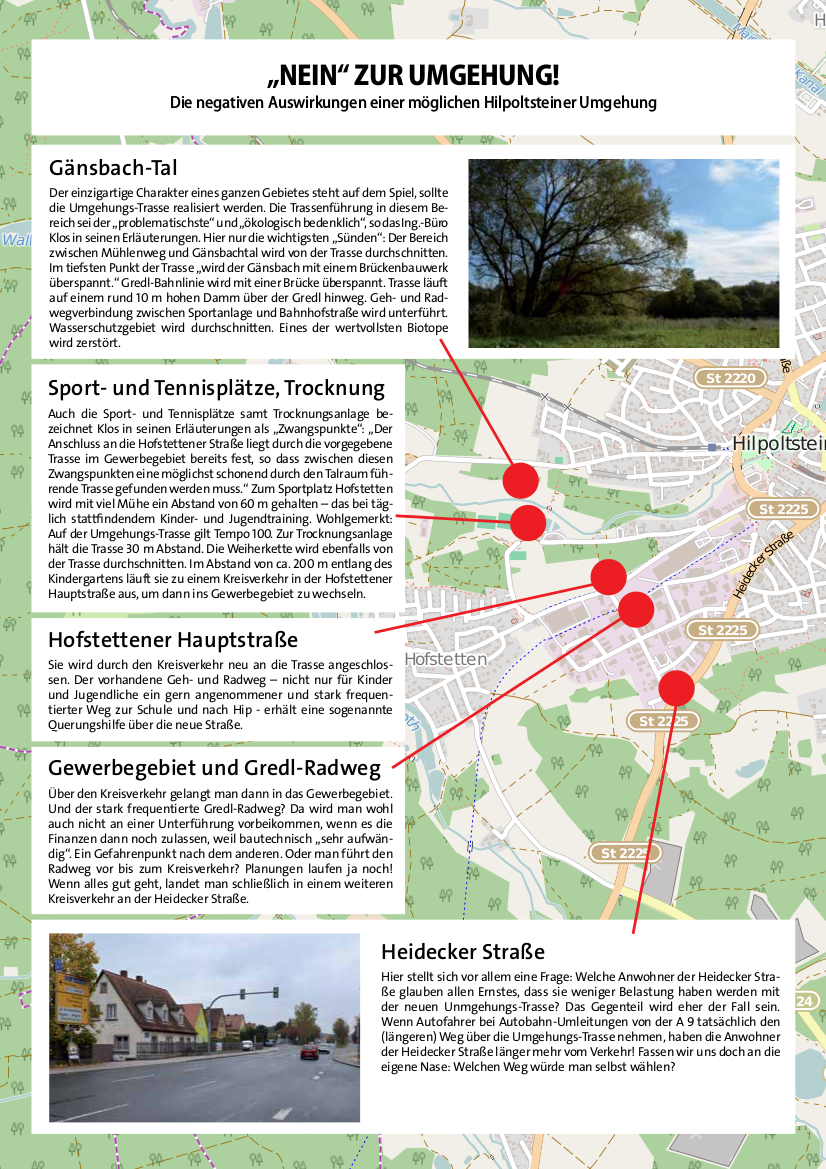
Auszug aus dem "Stadtspiegel", das Magazin der SPD Hilpoltstein, in dessen Ausgabe 10/2015 eine OSM-Karte zur Erläuterung der Auswirkungen einer Umgehungsstraße verwendet wurde.
(Quelle: http://www.spd-hilpoltstein.de/wp-content/uploads/2015/10/2015-10-web.pdf, abgerufen am 7. November 2015)
Licensing
![]()
![]()
![]()
This work is licensed under the Creative Commons Attribution-ShareAlike 2.0 License.
Attribution not specified as a parameter! THIS LICENSE ALWAYS REQUIRES ATTRIBUTION! Use {{CC-BY-SA-2.0|Attribution, typically name of author}} See Template:CC-BY-SA-2.0 for full description how this template should be used.
Note, there is
There is also
Attribution not specified as a parameter! THIS LICENSE ALWAYS REQUIRES ATTRIBUTION! Use {{CC-BY-SA-2.0|Attribution, typically name of author}} See Template:CC-BY-SA-2.0 for full description how this template should be used.
Note, there is
{{CC-BY-SA-2.0 OpenStreetMap}} for files based on old OSM map data, before the license change made on 2012-09-12.There is also
{{OSM Carto screenshot||old_license}} for files based on old OSM map data, before the license change made on 2012-09-12, created using OSM Carto map style.
File history
Click on a date/time to view the file as it appeared at that time.
| Date/Time | Thumbnail | Dimensions | User | Comment | |
|---|---|---|---|---|---|
| current | 12:17, 7 November 2015 | | 826 × 1,169 (711 KB) | Bigbug21 (talk | contribs) | Auszug aus dem "Stadtspiegel", das Magazin der SPD Hilpoltstein, in dessen Ausgabe 10/2015 eine OSM-Karte zur Erläuterung der Auswirkungen einer Umgehungsstraße verwendet wurde. (Quelle: http://www.spd-hilpoltstein.de/wp-content/uploads/2015/10/2015... |
You cannot overwrite this file.
File usage
The following page uses this file: