File:Inkatlas topo example.png
Jump to navigation
Jump to search


Size of this preview: 800 × 258 pixels. Other resolutions: 320 × 103 pixels | 1,240 × 400 pixels.
Original file (1,240 × 400 pixels, file size: 546 KB, MIME type: image/png)
Summary
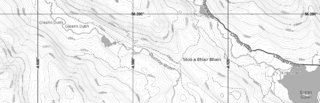
Part of a printable OSM-based map with elevation contours, generated on Inkatlas.com.
Licensing
| Contains map data © OpenStreetMap contributors, made available under the terms of the Open Database License (ODbL).
The ODbL does not require any particular license for maps produced from ODbL data, produced maps may be subject also to other licences. |
File history
Click on a date/time to view the file as it appeared at that time.
| Date/Time | Thumbnail | Dimensions | User | Comment | |
|---|---|---|---|---|---|
| current | 15:34, 20 October 2015 | 1,240 × 400 (546 KB) | Kontextify (talk | contribs) | Part of a printable OSM-based map with elevation countours, generated on Inkatlas.com. |
You cannot overwrite this file.
File usage
The following 4 pages use this file: