File:Kontur population vs openstreetmap.png
Original file (2,102 × 1,410 pixels, file size: 937 KB, MIME type: image/png)
Summary
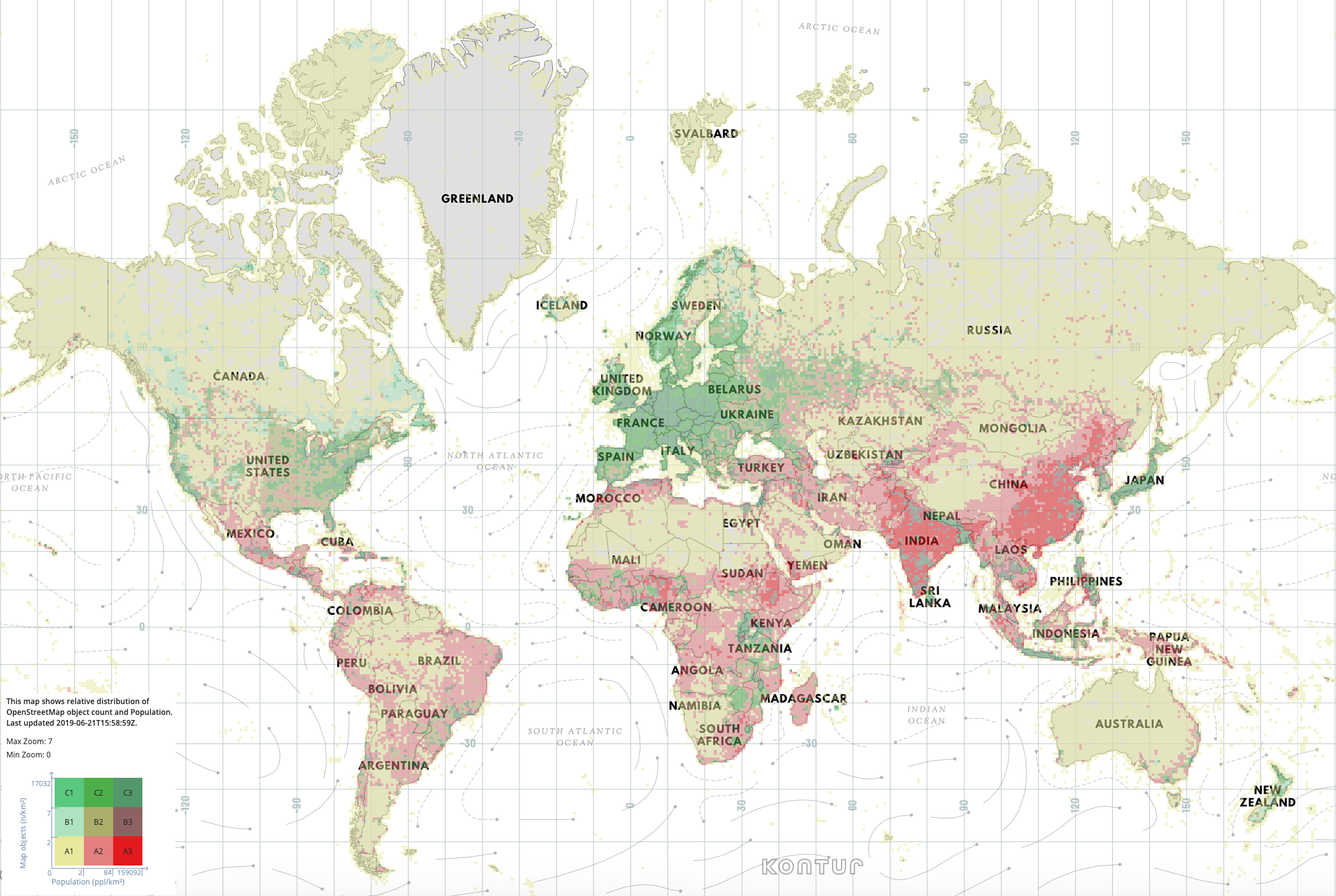
Kontur OpenStreetMap Coverage Map. Screenshot of the basemap appearing on "Disaster Ninja": http://disaster.ninja/live
This map shows relative distribution of OpenStreetMap object count and Population. Green means relatively more OpenStreetMap data, Red means relatively more (unmapped) population.
Basemap was "last updated 2019-06-21T15:58:59Z" at the time of the screenshot
Licensing
Screenshot release here CC-BY-SA-4.0 by permission
![]()
![]()
![]()
Attribution not specified as a parameter! THIS LICENSE ALWAYS REQUIRES ATTRIBUTION! Use {{CC-BY-SA-4.0|Attribution, typically name of author}} See Template:CC-BY-SA-4.0 for full description this template should be used.
| Contains map data © OpenStreetMap contributors, made available under the terms of the Open Database License (ODbL).
The ODbL does not require any particular license for maps produced from ODbL data, produced maps may be subject also to other licences. |
Attribution as given on the website:
Map Object Density © OpenStreetMap contributors, https://www.openstreetmap.org/copyright. European Commission, Joint Research Centre (JRC) Columbia University, Center for International Earth Science Information Network - CIESIN (2015): GHS population grid, derived from GPW4, multitemporal (1975, 1990, 2000, 2015). European Commission, Joint Research Centre (JRC) Dataset PID: http://data.europa.eu/89h/jrc-ghsl-ghs_pop_gpw4_globe_r2015a Facebook Connectivity Lab and Center for International Earth Science Information Network - CIESIN - Columbia University. 2016. High Resolution Settlement Layer (HRSL). Source imagery for HRSL © 2016 DigitalGlobe.
File history
Click on a date/time to view the file as it appeared at that time.
| Date/Time | Thumbnail | Dimensions | User | Comment | |
|---|---|---|---|---|---|
| current | 09:00, 25 June 2019 | | 2,102 × 1,410 (937 KB) | Harry Wood (talk | contribs) | Kontur OpenStreetMap Coverage Map http://disaster.ninja/live |
You cannot overwrite this file.
File usage
The following 6 pages use this file: