File:OpenStreetMap data used by Google Maps.png
Jump to navigation
Jump to search


Size of this preview: 800 × 475 pixels. Other resolutions: 320 × 190 pixels | 640 × 380 pixels | 1,024 × 608 pixels | 1,549 × 919 pixels.
Original file (1,549 × 919 pixels, file size: 962 KB, MIME type: image/png)
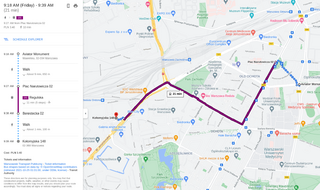
Summary
fair use claim for use of copyrighted data on unfree license
- there is no free equivalent, as in this case presence of this in Google Maps is interesting and Google Maps is not available under a free license
- this specific use is of significant interest, as the first documented case of OSM data being used in Google Maps
- it is also used here as form of news reporting (being linked for example on talk mailing list)
- used in Google article
File history
Click on a date/time to view the file as it appeared at that time.
| Date/Time | Thumbnail | Dimensions | User | Comment | |
|---|---|---|---|---|---|
| current | 21:44, 28 October 2021 | | 1,549 × 919 (962 KB) | Mateusz Konieczny (talk | contribs) | fair use claim for use of copyrighted data on unfree license |
You cannot overwrite this file.
File usage
The following page uses this file: