File:Phase1 osm cf wales.pdf
Jump to navigation
Jump to search

Size of this JPG preview of this PDF file: 800 × 409 pixels. Other resolutions: 320 × 164 pixels | 640 × 327 pixels | 1,024 × 524 pixels | 1,280 × 654 pixels | 2,400 × 1,227 pixels.
Original file (2,400 × 1,227 pixels, file size: 141 KB, MIME type: application/pdf)
Summary
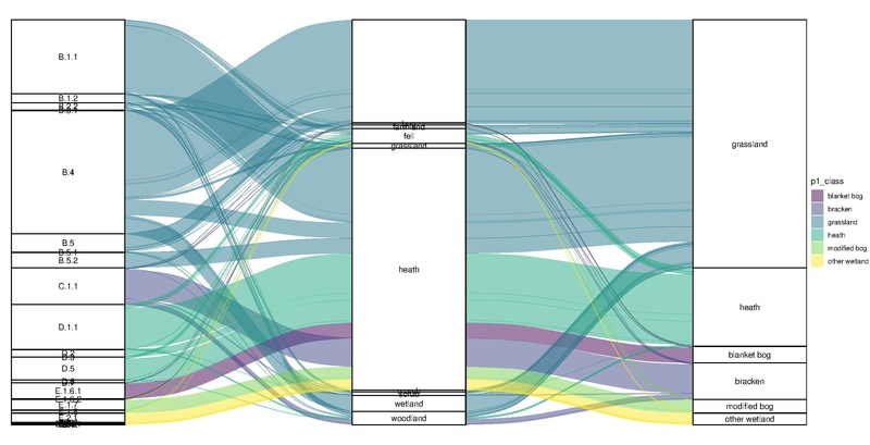
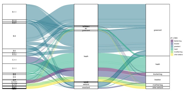
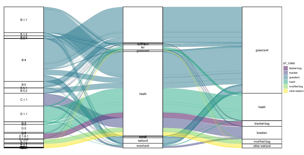
A comparison of Phase 1 Habitat Analysis for Wales and OSM landuse/natural tags. The focus is on natural=heath, but all major habitats identified as being included in a significant way were included.
The plot was made with ggalluvial (which has some limitations, but doing it in D3 seems a bit much right now).
Phase 1 data licenced under OGL, OSM data Odbl.
Licensing
| Contains map data © OpenStreetMap contributors, made available under the terms of the Open Database License (ODbL).
The ODbL does not require any particular license for maps produced from ODbL data, produced maps may be subject also to other licences. |
File history
Click on a date/time to view the file as it appeared at that time.
| Date/Time | Thumbnail | Dimensions | User | Comment | |
|---|---|---|---|---|---|
| current | 19:34, 22 October 2021 |  | 2,400 × 1,227 (141 KB) | SK53 (talk | contribs) | A comparison of Phase 1 Habitat Analysis for Wales and OSM landuse/natural tags. The focus is on natural=heath, but all major habitats identified as being included in a significant way were included. The plot was made with ggalluvial (which has some limitations, but doing it in D3 seems a bit much right now). Phase 1 data licenced under OGL, OSM data Odbl. |
You cannot overwrite this file.
File usage
There are no pages that use this file.