File:Power networks inaccurate data versus osm.png
Jump to navigation
Jump to search


Size of this preview: 800 × 301 pixels. Other resolutions: 320 × 120 pixels | 640 × 241 pixels | 1,319 × 496 pixels.
Original file (1,319 × 496 pixels, file size: 233 KB, MIME type: image/png)
Summary
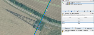
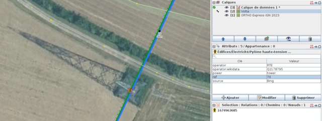
| Description | The picture shows the overlap of aerial imagery, open data and OSM. Open data is outdated while aerial imagery and OSM are up to date. |
|---|---|
| Author | François Lacombe |
| Source | IGN Ortho express 2023 |
| Date | 2023-12-30 |
Licensing
![]()
This file is a screenshot of the software JOSM, with imagery in background. It may include OpenStreetMap data, in such case ODbL license also applies.
![]()
"JOSM" (Java OpenStreetMap Editor – josm.openstreetmap.de) is free software released under the terms of the GNU General Public License as published by the Free Software Foundation; either version 2 of the license, or any later version.
License of imagery not specified! [→ template]
Data displayed: minimalFile history
Click on a date/time to view the file as it appeared at that time.
| Date/Time | Thumbnail | Dimensions | User | Comment | |
|---|---|---|---|---|---|
| current | 20:09, 30 December 2023 | 1,319 × 496 (233 KB) | Fanfouer (talk | contribs) | {{Information | description=The picture shows the overlap of aerial imagery, open data and OSM. Open data is outdated while aerial imagery and OSM are up to date. | source=IGN Ortho express 2023 | date=2023-12-30 | author=François Lacombe | other_versions= }} |
You cannot overwrite this file.
File usage
The following page uses this file: