User talk:Fanfouer
File:French_local_substation.png
Hi Fanfouer, did you draw the image File:Franch_local_substation.png? Or from where do you got it?
If it is from http://www.infos-reseaux.com/photos/image/122-poste-de-transformation-basse-tension the license is not right (and it would need to have the author and source be mentioned). However, it seems we do not have the license in this wiki (Template:CC-by-nc-nd-2.0) which is mentioned on the page footer (and I am not sure if it also applies to the images). --Aseerel4c26 (talk) 19:39, 7 July 2013 (UTC)
- Hi. Yes I'm the drawer and the URL you've mentioned is the original one.
- Indeed, I didn't find the exact license which match mine (CC BY-SA 3.0) but I've put my name at the bottom right corner.
- I don't see any argument against this kind of use in OSM since my name and my website is written on the image but feel free to improve this if you want.
- In the meantime, I realise I mistyped "French" with "Franch". Please, could you rename the file ? I feel very ashamed by such a mistake :s
- Cheers Fanfouer (talk) 21:50, 7 July 2013 (UTC)
- Thank you for the fast reply! If you did draw the image (if you are the author) then you can do whatever you like with it. You are also right that you can also use different licenses on different sites. Yes,OpenStreetMap seems to only have licenses which do not restrict modification or commercial use.
- It would be good if you would mention on the file page that you did draw the images, then it would be clear (to others like me) that you did not just copy the image from the mentioned website. By the way: I would think it is nicer if you would put your name and website (if you like) only on the file page but not inside the image. That distracts from the image.
- I have renamed (moved) the file and replaced the file name in the two pages which used it.
- A good drawing! --Aseerel4c26 (talk) 00:11, 8 July 2013 (UTC)
- You're welcome. I've updated the picture without any written reference but the URL is given in the description. Fanfouer (talk) 08:50, 9 July 2013 (UTC)
- Oh, nice, thank you! If you want to change the description (to add an URL) on the file page you need to use the "edit" on top of File:French local substation.png. --Aseerel4c26 (talk) 15:48, 9 July 2013 (UTC)
- You're welcome. I've updated the picture without any written reference but the URL is given in the description. Fanfouer (talk) 08:50, 9 July 2013 (UTC)
Split of the "Power Transmission Refinement Proposal"
Hi Fanfouer,
I think, you made a little mistake, while splitting the discussion page of the aforementioned proposal. The case of the South Bridge in Cologne should be part of the new "Power Support Proposal". I would change it myself, but I'm new to wiki-editing etc. and so I thought, I'll just let you know of the problem. Maybe you could move that section?
Greetings, --TOGA (talk) 22:20, 1 February 2015 (UTC)
- Hi Toga no problem.
- I didn't have time to think about the Cologne Bridge, taht's why I moved it into the new path proposal.
- I'll move once I will have find a solution. Cheers Fanfouer (talk) 22:47, 1 February 2015 (UTC)
Hello. Very nice graphics. Did you this file as SVG? Is a larger font possible? Read in German. --Reneman (talk) 16:58, 3 May 2015 (UTC)
- Hi Reneman, no SVG for the moment because I've finally edited the result with Paint.Net. But the base graphic (mast and antennas) is from Illustrator so I will save it to SVG and propagate the bitmap edition to the vectorial base soon. Keep following the file ;) Fanfouer (talk) 17:04, 3 May 2015 (UTC)
- great :o) --Reneman (talk) 17:12, 3 May 2015 (UTC)
Images save in... ???
Hello. See your pretty File:Street cabinet friendship.jpg, it has no License. :-(
Please read: Wiki Help#Include images from Wikimedia Commons and DE:Wiki Übersetzung#Bilder im Wiki (only in German, sorry). I would like to say: Your files:
- File:French power distribution RAS.jpg
- File:French distribution line with transition.jpg
- File:Power tower medium voltage line.jpg
- ...
are great. But if all over the world could use your picture, it would be even better. Why you don't put your photos in ![]() Wikimedia Commons? If you set your photos in Wikimedia Commons, you can add coordinates. Your pictures will be shown on maps ... (DE)Hallo. Sieh dein schönes Foto, es hat keine Lizens :-( . Bitte lies Wiki Help#Include images from Wikimedia Commons und DE:Wiki Übersetzung#Bilder im Wiki. Ich möchte dir sagen, deine Fotos sind großartig. Aber wenn die ganze Welt diese benutzen könnte, wäre es noch besser. Warum stellst du deine Fotos nicht bei Wikimedia Commons ein? Wenn du deine Fotos bei Commons einstellst, kannst du Koordinaten hinzufügen. Deine Bilder werden dann auch auf Karten gezeigt... --Reneman (talk) 18:46, 3 May 2015 (UTC)
Wikimedia Commons? If you set your photos in Wikimedia Commons, you can add coordinates. Your pictures will be shown on maps ... (DE)Hallo. Sieh dein schönes Foto, es hat keine Lizens :-( . Bitte lies Wiki Help#Include images from Wikimedia Commons und DE:Wiki Übersetzung#Bilder im Wiki. Ich möchte dir sagen, deine Fotos sind großartig. Aber wenn die ganze Welt diese benutzen könnte, wäre es noch besser. Warum stellst du deine Fotos nicht bei Wikimedia Commons ein? Wenn du deine Fotos bei Commons einstellst, kannst du Koordinaten hinzufügen. Deine Bilder werden dann auch auf Karten gezeigt... --Reneman (talk) 18:46, 3 May 2015 (UTC)
FR:Tag:power=plant
Bonjour, votre/ta dernière modification de la page est physiquement correcte (on transforme de l'énergie, on n'en crée pas) mais ambigüe : power=plant ne concerne pas les transformateurs. Tant dans la version anglaise que dans le langage courant on parle de production. Pourquoi ne pas dire production d'électricité ou de chaleur avec des générateurs ? C'est équivalent à la version anglaise mais plus précis.
- Merci pour le signalement, qui m'a permis en tout premier lieu de simplifier la description de
power=transformerpuisque ces appareils transforment une tension électrique et pas l'énergie en elle-même. - J'ai modifié la page des centrales à nouveau pour parler d'une production de ressources (électricité, chaleur, gaz, froid...) et indiqué que
power=transformern'était pas adapté dans ce contexte. Fanfouer (talk) 17:02, 8 January 2017 (UTC)
Confusing edits to Waterways page
Hi, I do not understand what the text you added in this edit is about, and it seems very confusing to mention highly specialized information about "Free flow and Pipe flow" right in the middle of a section about mapping rivers and such. Can you perhaps revisit this to make it more understandable, and move it into its own section on the page? --Tordanik 14:33, 3 April 2018 (UTC)
- That's right, a part of the original text is missing. Give me a couple of hours to correct it Fanfouer (talk) 16:56, 3 April 2018 (UTC)
- Update done, hope it's clearer and relevent Fanfouer (talk) 20:00, 3 April 2018 (UTC)
Need FR help with long descriptions
Hi, I was migrating key/tag descriptions to the new Data items, and noticed there are some French wiki pages with descriptions longer than 250 characters. Could you help make them shorter? Without it, iD editor will show strange truncated version. Also, please make sure there are no wiki markup in the description. (Feel free to help with the English ones too if you have time) Thanks!!! --Yurik (talk) 17:36, 15 February 2019 (UTC)
- Hi, glad you come here to ask for help. Should I edit the description on the wiki page or on the data item directly? Indeed, some descriptions need a bit of cleaning. All the best Fanfouer (talk) 21:12, 15 February 2019 (UTC)
- @Fanfouer: wiki pages will be enough - I will run the bot to update data items automatically. Hopefully some day we will just get rid of all the wiki page parameters (they automatically can be loaded from the data items anyway). --Yurik (talk) 21:47, 15 February 2019 (UTC)
- It's ok regarding French definitions guys. Fanfouer (talk) 22:00, 8 March 2019 (UTC)
- @Fanfouer: wiki pages will be enough - I will run the bot to update data items automatically. Hopefully some day we will just get rid of all the wiki page parameters (they automatically can be loaded from the data items anyway). --Yurik (talk) 21:47, 15 February 2019 (UTC)
New example in Tag:power=transformer#Distribution transformers
Hi, is the rating=250 kVA by any chance a typo? Looking at the plate, I see 50 kVA. —M!dgard [ talk ] 08:14, 10 April 2019 (UTC)
- That was indeed a typo, a big thank you for your help! Fanfouer (talk) 08:39, 10 April 2019 (UTC)
Assistance in mapping substations
I've just started learning how to map power infrastructure and am looking for help in understand how to map the details of a substation. I've read over the substation Wiki page, but am not knowledgeable enough to translate imagery into substation components. Specifically, I was starting with this substation. https://www.openstreetmap.org/way/104204446 Would you be willing to dialogue and share your expertise? I'm available on Slack @jared or can be messaged through https://www.openstreetmap.org/user/Jared%20Campbell. Thanks!
Oil and gas "power"
In my understanding of the English language Oil and gas power is totally an oxymoron. In OSM power has always been used as an synonym for the electric power industry (see your own words about power mappers, power grids, ...). For Oil & Gas there is the WikiProject Oil and Gas Infrastructure. Kind regards, Rumburak (talk) 12:31, 25 September 2019 (UTC)
- I've certainly confused power and energy. Nevertheless, that's not my words : this page exists since 2008 and mix electricity and O&G since its first version. I wasn't there in 2010 to know why it was relevent to ignite another project for O&G.
- It can be great to merge forces and find synergies between electricity grids and O&G pipelines mapping, can't you? Fanfouer (talk) 16:31, 25 September 2019 (UTC)
- I'm not against synergies – I map power lines as well as oil & gas pipelines since several years. But we should keep this separated in the Wiki. And if this hasn't been not done yet, it should be done now.--Rumburak (talk) 16:54, 26 September 2019 (UTC)
Power routing proposal.
Hello Fanfouer,
Excuse me that I didn't look at my pages recently. I'd be glad to continue discussions and consider your improvements. I'll accept any efforts from you, Bahnpirat, and any people who can and want to help working on this topic. Here are some my considerations that I'd like to strictly follow.
- The
route=*only for transportation vehicle routes. - Each circuit must be tagged individually.
- In Russia we already use my tagging schema with
power=circuitrelations. Web-site http://frexosm.ru/power/ visualizes power lines tagged with this method.
Surly (talk) 06:24, 5 March 2020 (UTC)
- Hi @Surly:. Thank you for your answer and your agreement to get this tagging reviewed. This is a nice render, thank you for showing it to us.
- Currently, all France and maybe part of Germany and Switzerland are described with
route=power([1]). I see no problem to make an automated edit totype=power+power=circuitonce accepted. We already described each circuit individually but currently no render use transportation-like power routes (@Bahnpirat: may have different concerns) - All your concerns will be ok from my point of view, let's go on the proposal Talk to get this tagging ready for voting Fanfouer (talk) 22:23, 6 March 2020 (UTC)
Label of data items
Hello, I please you not to change the labels ("libellé") of keys and tags in their data-items. The english entry for each data-item needs to be the same as the key (e.g. power) or the tag (e.g. power=plant).
Please notice Wiki Data_items and Talk:Data_items . Regards --Chris2map (talk) 10:58, 9 May 2020 (UTC)
- I appreciate you spent time to warn me about this, thank you. Could you please explain me or point me towards approriate documentation why should Engligh label contain the tag which duplicates P19 property of data items?
- Label is the only place to have readable text by human and sounds like an awkward place to make any logical linking. Fanfouer (talk) 12:37, 9 May 2020 (UTC)
- I try, but I also don't know the last word of wisdom. As you can see on the wiki pages, the concept of data items is not yet fully thought through. The key point for me is that the use here at OpenStreetMap is not about a definition or explanation of a term (as at Wikidata.org), but an explanation of a key or tag of OpenStreetMap. Therefore, in my opinion, the key or tag should remain as the title (here unfortunately "label"). The label actually belongs to the description or alias. For now this is the only way to easily recognize that it is about the respective key or tag, e.g. with links or in lists like "last changes" etc. --Chris2map (talk) 13:40, 9 May 2020 (UTC)
- The first thing which comes in my mind is the ability to translate it. I saw local translations of the tag while it is always in English in the database, it's pointless to translate a tag while it's really useful to translate a label. Isn't possible to list data items based upon their P19 property instead of label in change list? Fanfouer (talk) 18:43, 9 May 2020 (UTC)
- I try, but I also don't know the last word of wisdom. As you can see on the wiki pages, the concept of data items is not yet fully thought through. The key point for me is that the use here at OpenStreetMap is not about a definition or explanation of a term (as at Wikidata.org), but an explanation of a key or tag of OpenStreetMap. Therefore, in my opinion, the key or tag should remain as the title (here unfortunately "label"). The label actually belongs to the description or alias. For now this is the only way to easily recognize that it is about the respective key or tag, e.g. with links or in lists like "last changes" etc. --Chris2map (talk) 13:40, 9 May 2020 (UTC)
- To use the P19 as a title for all displaying in wiki could be a workaround, I would agree with. But I don't know the technical background and database links with others like Wikidata. Therefore, the proposal should flow into the discussion on Talk:Data_items. Would you place it there? --Chris2map (talk) 19:20, 9 May 2020 (UTC)
- Get me well, that's not a workaround : that's how things are supposed to run. P19 is the constant and unique identifier of tag linked to a data item. I'll ask Yuri how listing could be improved with this value and allowing English label to be human readable. Fanfouer (talk) 23:11, 9 May 2020 (UTC)
- OK good! It is only important to me that I can recognize the key or tag at any time, with every link and such. --Chris2map (talk) 07:01, 10 May 2020 (UTC)
- Get me well, that's not a workaround : that's how things are supposed to run. P19 is the constant and unique identifier of tag linked to a data item. I'll ask Yuri how listing could be improved with this value and allowing English label to be human readable. Fanfouer (talk) 23:11, 9 May 2020 (UTC)
- To use the P19 as a title for all displaying in wiki could be a workaround, I would agree with. But I don't know the technical background and database links with others like Wikidata. Therefore, the proposal should flow into the discussion on Talk:Data_items. Would you place it there? --Chris2map (talk) 19:20, 9 May 2020 (UTC)
Water Works Proposal
Hi Fanfouer, see you're also particularly interested and active in the water works arena. Do you already some drafted thoughts or ideas on what the water_works proposal page could look like? I saw that you mentioned to me here proposing water_works=storage, which doesn't yet exist, but I would be happy to start working on. Would you recommend that I start something in my own personal page or go ahead and create the proposal and start editing it there? --IanVG (talk) 20:11, 17 July 2020 (UTC)
- Hi @IanVG:, thank you for this message. I plan to write something for
waterworks=*one of those days. We can start thinking about it here Waterworks_proposal. It may be good to vote Pumping proposal first but ideas can be gathered anytime from now on. It will be great to do team work to write this proposal. Fanfouer (talk) 20:41, 23 July 2020 (UTC)
Circuits only for cable?
Hi Fanfouer, I've seen you work on the technical side and so I wanted to hear your opinion.
The page circuits=* describes the property as if circuits=* should be used mainly for cable. But circuits=* is also important for power=line. It is also much easier to detect. It is also described on the wiki page power=line, in JOSM and the circuits are shown on the Open Infrastructure Map.
I had updated the German page and added a few examples, but it was changed back. The English side would have to be renewed first. If you agree, can you help? --geozeisig (talk) 14:35, 17 August 2020 (UTC)
- Hi and thank you to bring this to my attention. I agree with you,
circuits=*was firstly introduced forpower=cablebut is suitable for any power line. - The page has been updated to have a better meaning on this point. I'll translate it into French asap. Fanfouer (talk) 00:08, 19 August 2020 (UTC)
- Thanks. The sentence still bothers me: "Otherwise this tag is not needed for overhead power lines as the number of circuits can be derived from the cables=* tag." Sometimes it's not that easy. We should always specify the number if it is not equal to 1. There are also cases where only 2 cables form a circuit: E.g. with traction current in Germany Example.--geozeisig (talk) 13:47, 19 August 2020 (UTC)
- Hello Fanfouer, I have followed the problem and would like to contribute my opinion here. I myself have mapped several substations with overhead power lines. There are already entries from the run-up to this on the German discussion page. https://wiki.openstreetmap.org/wiki/DE_talk:Key:circuits The day has been described so far. “The label is primarily intended for underground cable connections where the number of physical cables is unknown or has no simple relationship to the number of circuits. Otherwise, this tag is not required for overhead lines, as the number of circuits can be derived from the cables = * tag. " The use of this entry for above-ground high-voltage overhead lines also leads to confusing images in the view of the Open Infrastructure Map. The exact recording would be useful, but the renderer programs show a wrong interpretation. The use of this tag for above-ground high-voltage overhead lines for normal, simple double systems is impractical in my opinion and, especially in node areas such as substations, extremely confusing. So far I had only given the day with two double systems as 'two' and I think the display is okay. Another problem would be the consistent display of two and more double systems with tag 'four' and up, since only a maximum of three lines are shown next to each other in the Open Infrastructure Map. I therefore ask you to check the exact use for overhead lines. I suggest only using the entry if the number of circuits in a double system exceeds. Two screenshots as problem examples: https://up.picr.de/39258882pg.jpg https://up.picr.de/39258908vw.jpg simple double system: no circuits entry https://commons.wikimedia.org/wiki/File:Burstadt_Hoheneck_Suspension_Tower.JPG double double system: Circuits entry 2 https://commons.wikimedia.org/wiki/File:Tragmast.jpg Thank you for your attention Google translation Bahntech (talk) 22:09, 19 August 2020 (UTC)
- Hi @Geozeisig:. I completely second your opinion, I'll update the page once situations mentioned by Bahntech will have been reviewed.
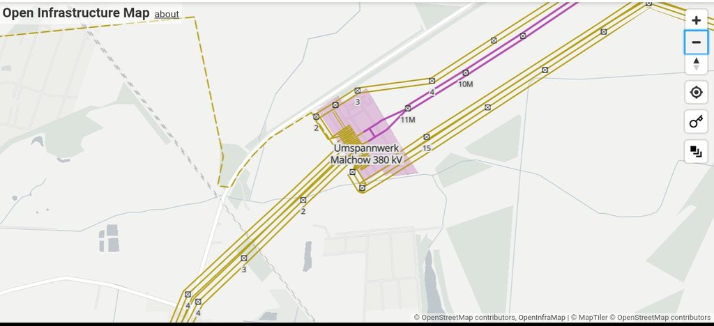
- Hi @Bahntech:. Thank you to contribute here and for the translation. Regarding The exact recording would be useful, but the renderer programs show a wrong interpretation: then we will have to correct the render. Geozeisig sounds right upside: we should be able to give a positive numeric value for any power line/cable/connection in any situation for sake of simplicity, that involves more than 1 circuit (whatever the amount of conductors, defaulting to 3 can be wrong in some situations, especially in countries with dedicated traction power grid like Germany). Could you provide links to OSM features that got a wrong render on openinframap please? I can't find the Malchow power substation anywhere unfortunately.
- Finally, don't expect to be able to make associations like x circuits have 3 conductors and y circuits have 2 conductors on this 15 conductors power line with
cables=*andciruits=*. It's a different job for circuits relations that have been in debate for years. Fanfouer (talk) 10:56, 20 August 2020 (UTC)- Hello @Fanfouer:, I would be happy to provide the coordinates for the example “Umspannwerk Malchow”: https://www.openstreetmap.org/#map=17/52.58979/13.49467&layers=N Here again a short description of the error in the Open Infrastructure Map: 1. Photo- https://up.picr.de/39258882pg.jpg In this zoom level the yellow lines shown overlap. It looks very confusing and uncoordinated. At this zoom level, the “circuits” label should not yet be evaluated. 2. Photo- https://up.picr.de/39258908vw.jpg In this zoom level, the yellow power lines are shown with three circuits, but in reality there are four circuits (Circuits = 4). As a rule, I am familiar with power poles with a maximum of six circuits. https://commons.wikimedia.org/wiki/File:GER_Autobahn_001_2016_-_Hochleitungsmast.jpg 3rd photo- https://up.picr.de/39267177wn.jpg When bundled with a traction circuit, the line color is displayed incorrectly. The traction power lines with 16.7 Hertz and 110 kilovolt single-phase AC voltage are normally displayed in gray. In the bundle display, however, they are incorrectly displayed in yellow. The frequency entry is not evaluated correctly here. You may be able to choose a different color for 16.7 Hz (16.66 Hz) traction circuits. Thank you for your attention (google translation). Alternative renderer display without circuit number display: https://www.flosm.de/html/Stromnetz.html?lat=52.5892070&lon=13.4938403&r=292.87160&st=0&sw=cabledistributioncabinet,powerbay,powerbusbar,powercable,powercompensator,powerconverter,powerline,powerline110k,powerline115k,powerline20k,powerline220k,powerline220v,powerline225k,powerline30k,powerline380k,powerline3k,powerline400k,powerline420k,powerline500v,powerline50k,powerline6k,powerline750k,powerline765k,powerlinedchigh,powerlinedclow,powerpole,powersubstation,powerswitch,powertower,transformer Bahntech (talk) 14:59, 21 August 2020 (UTC)
- Thank you @Bahntech: for those clear statements. First of all, I see no issues with tagging around Malchow power substation. It seems we all agree on what
cables=*andcircuits=*mean. - Furthermore, you know, OpenInfraMap is a render which tries to make infrastructure topics accessible and provide a kind of representative map of most parts of complex infrastructure. Circuits render goes up to three parallel lines (3 lines means 3 or more circuits). I understand your points about how this render should be improved and you'll be more than welcome to start issues on repository. Even it's not perfect, OIM brings large benefits with circuits rendering as parallel lines with colors according respective voltages. It's not an easy business.
- Finally, we've got problems with frequency actually: it shouldn't be mentioned on lines but on not-yet-reviewed circuits relations. Frequency is not a property of physical cables but on what system runs over them. Cables won't be changed in case of frequency modification. That's why I hope routing proposal be soon finished and reviewed but it's a different topic than circuits and cables. All the best Fanfouer (talk) 22:53, 21 August 2020 (UTC)
- Some clarifications has been made on
circuits=*page @Geozeisig: Fanfouer (talk) 22:47, 27 August 2020 (UTC)
- Some clarifications has been made on
- Thank you @Bahntech: for those clear statements. First of all, I see no issues with tagging around Malchow power substation. It seems we all agree on what
- Hello @Fanfouer:, I would be happy to provide the coordinates for the example “Umspannwerk Malchow”: https://www.openstreetmap.org/#map=17/52.58979/13.49467&layers=N Here again a short description of the error in the Open Infrastructure Map: 1. Photo- https://up.picr.de/39258882pg.jpg In this zoom level the yellow lines shown overlap. It looks very confusing and uncoordinated. At this zoom level, the “circuits” label should not yet be evaluated. 2. Photo- https://up.picr.de/39258908vw.jpg In this zoom level, the yellow power lines are shown with three circuits, but in reality there are four circuits (Circuits = 4). As a rule, I am familiar with power poles with a maximum of six circuits. https://commons.wikimedia.org/wiki/File:GER_Autobahn_001_2016_-_Hochleitungsmast.jpg 3rd photo- https://up.picr.de/39267177wn.jpg When bundled with a traction circuit, the line color is displayed incorrectly. The traction power lines with 16.7 Hertz and 110 kilovolt single-phase AC voltage are normally displayed in gray. In the bundle display, however, they are incorrectly displayed in yellow. The frequency entry is not evaluated correctly here. You may be able to choose a different color for 16.7 Hz (16.66 Hz) traction circuits. Thank you for your attention (google translation). Alternative renderer display without circuit number display: https://www.flosm.de/html/Stromnetz.html?lat=52.5892070&lon=13.4938403&r=292.87160&st=0&sw=cabledistributioncabinet,powerbay,powerbusbar,powercable,powercompensator,powerconverter,powerline,powerline110k,powerline115k,powerline20k,powerline220k,powerline220v,powerline225k,powerline30k,powerline380k,powerline3k,powerline400k,powerline420k,powerline500v,powerline50k,powerline6k,powerline750k,powerline765k,powerlinedchigh,powerlinedclow,powerpole,powersubstation,powerswitch,powertower,transformer Bahntech (talk) 14:59, 21 August 2020 (UTC)
- Hello Fanfouer, I have followed the problem and would like to contribute my opinion here. I myself have mapped several substations with overhead power lines. There are already entries from the run-up to this on the German discussion page. https://wiki.openstreetmap.org/wiki/DE_talk:Key:circuits The day has been described so far. “The label is primarily intended for underground cable connections where the number of physical cables is unknown or has no simple relationship to the number of circuits. Otherwise, this tag is not required for overhead lines, as the number of circuits can be derived from the cables = * tag. " The use of this entry for above-ground high-voltage overhead lines also leads to confusing images in the view of the Open Infrastructure Map. The exact recording would be useful, but the renderer programs show a wrong interpretation. The use of this tag for above-ground high-voltage overhead lines for normal, simple double systems is impractical in my opinion and, especially in node areas such as substations, extremely confusing. So far I had only given the day with two double systems as 'two' and I think the display is okay. Another problem would be the consistent display of two and more double systems with tag 'four' and up, since only a maximum of three lines are shown next to each other in the Open Infrastructure Map. I therefore ask you to check the exact use for overhead lines. I suggest only using the entry if the number of circuits in a double system exceeds. Two screenshots as problem examples: https://up.picr.de/39258882pg.jpg https://up.picr.de/39258908vw.jpg simple double system: no circuits entry https://commons.wikimedia.org/wiki/File:Burstadt_Hoheneck_Suspension_Tower.JPG double double system: Circuits entry 2 https://commons.wikimedia.org/wiki/File:Tragmast.jpg Thank you for your attention Google translation Bahntech (talk) 22:09, 19 August 2020 (UTC)
Utility poles proposal
Have read the draft Utility poles proposal and interested in contributing insights from Ireland where we have a lot of power, telecom and cable networks (many overhead in non-urban areas). Let me know the best way to contribute and try and progress this. --Dónal (talk) 20:42, 27 August 2020 (UTC)
- Hi and thank for this message. I'd be really interested to know more about your local experience in tagging utility poles, can you elaborate a bit more on proposal's Talk page please?
- Secondly, local and relevent examples are always missing from proposals, so you'll be more than welcome to add one or two telecom, fibre or power poles pictures from your neighbourhood in the example section.
- This proposal is expected to be completed during H2 2020 and be voted by Q1 2021 (I hope so) Fanfouer (talk) 22:18, 27 August 2020 (UTC)
Pumping Proposal
Hello Fanfouer, I just want to say, I wish I had been able to vote in support of your pumping proposal that you created. I see there is a bit of opposition, so I wanted to ask if there was anyway I could provide support for this proposal. Specifically, whate areas do you feel like pictures/further clarification are needed? I'm looking at the proposal and think that addressing the "clearer rationale" point brought up by several of the mappers may be a good start. I didn't want to make any modifications before asking however. Best --IanVG (talk) 22:24, 30 November 2020 (UTC)
- Hi @IanVG: and thank you for this kind message. I plan to make a little cleanup in coming days to resolve some of raised points during the first vote. Here is what I have in mind:
- Move proposed values for
pump=*topump_mechanism=* - Remove deprecation of
pump=poweredandpump=manual - Keep
mechanical_driver=*andmechanical_coupling=* - Add some minor improvements to Rationale chapter
- Optionally add examples but I didn't manage to find usable pictures of several mechanisms
- Any additional point I miss here
- I'm still busy on other business but I'll be back on this shortly. All the best Fanfouer (talk) 00:07, 1 December 2020 (UTC)
- Hi @Fanfouer: great thank you for the speedy reply. I made a sandbox page where I am hosting some of the edits that may prove helpful to the proposal. Take a look here or at User:IanVG/Sandbox. Let me know if you were looking for other kinds of help.
- Concerning the rationale, you're making the right points but I think it is getting buried beneath the explanation first. I would bring to the top the couple of lines: "Mappers can't currently... *to* ...in developed areas." That hits the nail on the head.
- Another comment: "Pumps have been mapped for years in OSM when installed on water wells only. Let's generalize this approach in many other activities." It's a bit wordy, this could also be something like "This proposed tag will allow the mapping of pumps beyond water wells only." That's all for now from me though.
- Best--IanVG (talk) 05:18, 1 December 2020 (UTC)
- Edit: I'd like to add that wikimedia has proven a great resource for finding the pictures and examples I've put on the sandbox page.--IanVG (talk) 14:59, 1 December 2020 (UTC)
- That's really cool material you found, thank you, especially for rope pump! I've completed examples and changed tagging accordingly. Some improvements remains to be made on Rational, depending on your opinion. Fanfouer (talk) 17:27, 1 December 2020 (UTC)
- Edit: I'd like to add that wikimedia has proven a great resource for finding the pictures and examples I've put on the sandbox page.--IanVG (talk) 14:59, 1 December 2020 (UTC)
mechanical_driver=powered missing!
Hey @Fanfouer:! Don't know if you missed this or if your ideas changed over time, but I see that in the discussion page for the pumping proposal that you mention that pump=powered should be modified (at least for the water_well case) to mechanical_driver=powered, in the general case as a minimum before refining and adding detail if known via mechanical_driver=electric_motor;combustion_enginer;turbine;etc. This seems like a big sticking point for several other OSM mappers who are resisting the proposal. If you already aware of this, I apologize for my urgency, I just see that the voting has opened, and even though we have support so far, I'm not sure the proposal would survive a second wave of opposition.
The changes this would entail to the proposal, I believe, would be adding a value to the mechanical_driver=* list and adding a bullet point to deprecate pump=powered in favor of mechanical_driver=powered. This change may as well extend to cover pump=manual, which I believe would be deprecated in favor of mechanical_driver=manual. Pump=* in general looks like it should deprecated perhaps? Let me know your thoughts. Best, --IanVG (talk) 19:58, 21 December 2020 (UTC)
- Hi @IanVG:, I'm indeed aware of this and choose to don't include
mechanical_driver=poweredin the list finally since it brings less value to movepump=poweredtomechanical_driver=powered. Mappers should look for more accurate information to fillmechanical_driver=*with a value referring to an actual device (electric motors, combustion engines are actual devices, powered isn't). As it's only a list of values, it won't be forbidden to add extra possibilities matching the original definition in the future if required. - This proposal won't make
pump=*deprecated, future will tell if mappers/consumers move to proposed tagging only or still usepump=*but it's less a problem for now as mechanisms go inpump_mechanism=*. I Hope you're not disappointed by this choice Fanfouer (talk) 22:52, 22 December 2020 (UTC)
- Ah, okay. Yes, I must have gotten confused with the order of messages regarding this issue on the talk page, but your logic here makes sense. No disappointment! And I like to think that your proposal should certainly gain approval over the long term! --IanVG (talk) 15:58, 23 December 2020 (UTC)
- Thank you for your help, it's a long run trip Fanfouer (talk) 18:57, 29 December 2020 (UTC)
- Ah, okay. Yes, I must have gotten confused with the order of messages regarding this issue on the talk page, but your logic here makes sense. No disappointment! And I like to think that your proposal should certainly gain approval over the long term! --IanVG (talk) 15:58, 23 December 2020 (UTC)
file license
Are you author of image https://wiki.openstreetmap.org/wiki/File:Street_cabinet_friendship.jpg ?
Or is it copied from some other place (which one?)?
Would you agree to open licensing of this image, allowing its use by anyone (similarly to your OSM edits)?
Would you be OK with https://wiki.openstreetmap.org/wiki/Template:CC0 (it allows use without attribution or any other requirement) ?
Or do you prefer to require attribution and some other things using https://wiki.openstreetmap.org/wiki/Template:CC-BY-SA-4.0 ?
Mateusz Konieczny (talk) 11:48, 25 March 2021 (UTC)
- Unfortunately and initially, this image came from an unknown source, kept on my hdd for years.
- I very recently managed to find the author and mailed him to get his approval, even after years of non-credited usage.
- File and linking pages will be edited accordingly depending on what his answer will be. Fanfouer (talk) 22:53, 25 March 2021 (UTC)
- Thanks! I hope that it solvable as photo is lovely Mateusz Konieczny (talk) 07:11, 26 March 2021 (UTC)
- Unfortunately I've got no answer so far. @Mateusz Konieczny: it was shot in Olsztyn, Poland by Adam Okuciejewski and Szymon Czarnowski. Do you see a way to reach them? I've tried on Behance only but you may find a more local way, mightn't you? Fanfouer (talk) 17:57, 19 May 2021 (UTC)
- That's ok @Mateusz Konieczny:, Authors answered me last June and allowed picture usage for non profit only (so I chose CC BY-SA-NC 4.0 licence and update description). Fanfouer (talk) 17:10, 25 July 2021 (UTC)
- Unfortunately I've got no answer so far. @Mateusz Konieczny: it was shot in Olsztyn, Poland by Adam Okuciejewski and Szymon Czarnowski. Do you see a way to reach them? I've tried on Behance only but you may find a more local way, mightn't you? Fanfouer (talk) 17:57, 19 May 2021 (UTC)
- Thanks! I hope that it solvable as photo is lovely Mateusz Konieczny (talk) 07:11, 26 March 2021 (UTC)
Hello, I've recently interested about this proposal which created by you, and are you still working on it? I'm asking because I think the proposal could be expanded. Let me know if you're still interested about the proposal!Mappinglander (talk) 17:54, 17 May 2021 (UTC)
- Hi @Mappinglander: and thank you for this message. This proposal didn't get completed indeed and it could great to reboot it. It's ok to discuss what you had in mind about and maybe takes it to the vote once completed. Feel free to add new topics on Talk page. Fanfouer (talk) 17:47, 19 May 2021 (UTC)
Waterworks Proposal
Hey @Fanfouer:! Hope all is well. I am working on the waterworks proposal page. Some of my edits have been pretty rough, but please take a look when you can and let me know what you think. I am still wondering exactly which tags should apply to the waterworks= key. Should it refer to the system type that the water is a part of (e.g. supply, sanitary, storm)? Or should it apply directly as a replacement to the various keys currently in use to describe waterworks features (e.g. man_made, landuse, emergency).
You have vastly more experience than I do in this realm, and I would highly value your input. --IanVG (talk) 18:00, 24 July 2021 (UTC)
- Hi @IanVG: thank you for those improvements. It's ok to go on water proposal, a few months will be required to get a fully usable classification. Let's discuss on the proposal's Talk page, i've already added a new subject there. Fanfouer (talk) 17:30, 25 July 2021 (UTC)
Power plant parts proposal
Hi!
I've started working on a new proposal for tagging parts/phases of power plants to try and remove some confusion around tagging (mostly with wind farms). I'd appreciate any comments on the talk page: Proposed_features/Power_plant_parts Russss (talk) 14:28, 10 October 2021 (UTC)
- Nice, thank you Russss :) Fanfouer (talk) 13:41, 11 October 2021 (UTC)
small installations
Hi there,
I've started two discussions on the topic of these "small installations". See https://wiki.openstreetmap.org/wiki/Talk:Key:generator:output#Use.2Fabuse_of_the_tag_to_add_.22small_installation
- Thank you @Joost schouppe:. I've replied to both threads. Fanfouer (talk) 09:40, 17 November 2021 (UTC)
What is the license of this aerial imagery?
https://wiki.openstreetmap.org/wiki/File:Power_transformers_main_auxiliaries.png Mateusz Konieczny (talk) 12:12, 2 June 2022 (UTC)
- It's imagery from Enedis we (OSMF French local chapter) got from special agreement. I'll be seeking their acknlowledgment to put this particular extract under CC BY-SA 4.0 Fanfouer (talk) 20:44, 6 June 2022 (UTC)
The same applies to File:Power insulator transition as a node.jpg - what is the license of aerial imagery here? Mateusz Konieczny (talk) 11:18, 2 March 2024 (UTC)
Is it your image?
https://wiki.openstreetmap.org/wiki/File:French_fibre_PCP.jpg - and others with "François Lacombe - www.infos-reseaux.com".
Are these your images, that you have taken photo of? I am marking them as yours as it seems to be indicated by description - but I want to fully confirm this Mateusz Konieczny (talk) 20:05, 6 June 2022 (UTC)
- Yes sir, all image described as this are taken or drawn by me personally. Thank you to clarify this with such repetitive work Fanfouer (talk) 20:44, 6 June 2022 (UTC)
substation=industrial
[2] Most industrial substations in the US are operated by 'the traditional grid company'. And I think it's like that in many other places in the world, too. Hiausirg (talk) 07:26, 3 July 2022 (UTC)
- Random example where it is clearly visible: [3] Industrial substation, Georgia Power is the traditional grid company. (Location) Hiausirg (talk) 07:37, 3 July 2022 (UTC)
- The grid company only operates the protective systems of incoming power lines. The industrial company then operates transformers, switching and many systems ensuring supply reliability. As many private substations, power transit between incoming lines is not allowed in normal operation (they are visually not connected).
- The logo of power grid operator means network terminates here (and protective systems are in operation). Same in France, the logo of
operator=RTEis always visible but common rules state that industrial company is the operator of downstream components in the substation (not to mention they own them). - I can update the
substation=industrialpage to make it clearer. Fanfouer (talk) 18:04, 3 July 2022 (UTC)- Sounds good, thanks for letting me know. Hiausirg (talk) 04:08, 4 July 2022 (UTC)
- You're welcome. I've added more details and visual example to get where the limit may be Fanfouer (talk) 21:40, 4 July 2022 (UTC)
- Sounds good, thanks for letting me know. Hiausirg (talk) 04:08, 4 July 2022 (UTC)
Boundary markers proposal
I have created a proposal for an extended tagging scheme for boundary markers by mostly copying your utility markers proposal. If you are interested you are welcome to comment on it: https://wiki.openstreetmap.org/wiki/Proposed_features/Boundary_markers_proposal --Lkw (talk) 06:45, 7 September 2022 (UTC)
- Thanks for this notice! This proposal is the right way find solutions. I've forwarded it into our discussion about subject=* on tagging mailing list. Fanfouer (talk) 07:41, 7 September 2022 (UTC)
Photo request
Can you maybe take photo or find replacement for https://wiki.openstreetmap.org/wiki/File:Armoire_Eclairage_Public.png ? Mateusz Konieczny (talk) 07:53, 7 September 2022 (UTC)
- Why? This photo was shot by uploader himself. I'll go back to him to ask for proper license information. Fanfouer (talk) 07:55, 7 September 2022 (UTC)
- It is not really clear, people also uploaded files from random places on internet without stating source. If you can reach them - it would be great, they ignored talk page message. See also this discussion Mateusz Konieczny (talk) 07:57, 7 September 2022 (UTC)
Heat pump
Are the heat pumps classified under Tag:generator:type=heat_pump or under Tag:generator:method=heat_pump?
I hope not that the small ones, which are now more and more often in front of a single house, are mapped. However, there are now larger ones that generate heat for district heating from river water or geothermal water.
Example: River water heat pumps on the river Spree--geozeisig (talk) 05:47, 24 June 2023 (UTC)
- Hi, heat pumps are no generators: they gather dispersed heat in one environnement (let's say open air) and provide it downstream in a concentrated form. Electricity is needed to make the system run but produces no heat it self. To me, a dedicated tag should be used instead of
power=generatordedicated to machines that convert energy from one form to another. generator:type=heat_pumpshould be deprecated from that perspective Fanfouer (talk) 09:48, 24 June 2023 (UTC)- As I once learned in physics all generators convert energy only into another form, the energy becomes not more and also not less.
- Conservation of energy on Wikipedia In physics and chemistry, the law of conservation of energy states that the total energy of an isolated system remains constant; it is said to be conserved over time. Energy can neither be created nor destroyed; rather, it can only be transformed or transferred from one form to another.
- In this sense, a heat pump is a generator method. Maybe we should add
generator:method=heat_pump. --geozeisig (talk) 15:29, 24 June 2023 (UTC)- I agree to your definitions. However, can you explain what actual conversion a heat pump does please? Fanfouer (talk) 15:26, 25 June 2023 (UTC)
- The function of a heat pump is explained in Heat pump on Wikipedia or also Ground source heat pump on Wikipedia. The tag
generator:type=heat_pump(76x) refers to geothermal sources until now. No method is mentioned on the generator:type page. My question is whether the methodgenerator:method=heat_pump(7x) would be better for everything. --geozeisig (talk) 05:18, 26 June 2023 (UTC)
- The function of a heat pump is explained in Heat pump on Wikipedia or also Ground source heat pump on Wikipedia. The tag
- I agree to your definitions. However, can you explain what actual conversion a heat pump does please? Fanfouer (talk) 15:26, 25 June 2023 (UTC)
- Wikipedia explains heat pumps as transfer devices, not converting devices. Thus they are no generators. No actual energy conversion occurs. So
generator:method=*norgenerator:type=*are not suitable to deal with them. Fanfouer (talk) 07:19, 26 June 2023 (UTC)
- Wikipedia explains heat pumps as transfer devices, not converting devices. Thus they are no generators. No actual energy conversion occurs. So
Map license
https://wiki.openstreetmap.org/wiki/File:Hydropower_underground_water_drains_map.jpg
You have taken this photo, right? (like other photos uploaded from your account, unless marked otherwise)
But what is the license of the map?
Mateusz Konieczny (talk) 14:50, 15 March 2024 (UTC)
- Hi, yes I took the picture. From french law perspective it's considered as a quote of copyrighted material (as it comes from public archives).
- The actual map is way wider than we see on the picture, and I only got the right to publicly quote it.
- Is it ok for this wiki? Fanfouer (talk) 15:57, 15 March 2024 (UTC)
- I edited description to make situation more clear Mateusz Konieczny (talk) 17:26, 17 June 2024 (UTC)
- Hello, Fanfouer! Do you have any requisites of the full map to search in archives? As far as I know, many documents from archives of France are scanned and are available for download on official sites. Maybe you ever have link to thos one? It will be very interesting to see the full map, I love to collect retro technical & engineering drawings :) AnakinNN (talk) 06:06, 27 May 2025 (UTC)
- Hello, very few of W series, not to say none, (second part of 20th century) are digitized. The full map isn't available online for instance, you have to visit archives in person to find them Fanfouer (talk) 06:14, 27 May 2025 (UTC)
- Hello, Fanfouer! Do you have any requisites of the full map to search in archives? As far as I know, many documents from archives of France are scanned and are available for download on official sites. Maybe you ever have link to thos one? It will be very interesting to see the full map, I love to collect retro technical & engineering drawings :) AnakinNN (talk) 06:06, 27 May 2025 (UTC)
- I edited description to make situation more clear Mateusz Konieczny (talk) 17:26, 17 June 2024 (UTC)
imagery: IGN bdtopo
What is the license of their imagery?
I am asking for https://wiki.openstreetmap.org/wiki/File:Power_400kV_substation_disconnectors_aerial.png#Licensing
Mateusz Konieczny (talk) 17:28, 17 June 2024 (UTC)
- Hello @Mateusz Konieczny:, IGN BdTopo is licensed under French government open licence (as of 2017-638 decree). Furthermore here it a so tiny extract it could be considered as a quote of the original material which is usually free (but mentioning the source and the licence is good anyway).
- I'm not sure of the licence tu use in the wiki template, what do you think? Fanfouer (talk) 20:11, 15 August 2024 (UTC)
- Not sure, for now I added it as a freeform note. Mateusz Konieczny (talk) 09:47, 17 September 2024 (UTC)
Aerial source
Do you remember source and license of aerial used at https://wiki.openstreetmap.org/wiki/File:Power_portal_transition_as_a_node.jpg ?
If yes, could you add it to page there? Mateusz Konieczny (talk) 16:40, 15 August 2024 (UTC)
- Hello @Mateusz Konieczny:, it's IGN BdOrtho imagery as well under the same condition as above. Fanfouer (talk) 20:11, 15 August 2024 (UTC)
Pole labels
https://weeklyosm.eu/archives/17778 mentioned your interview. Any useful pole labels in France? Jidanni (talk) 06:58, 3 April 2025 (UTC)
- Hi @Jidanni:, thank you for pointing me this out because I didn't notice yet! Unfortunately no useful pole labels in France. Operators are forced to put simple numbers by law but they only exist on transmission towers in practice. Switzerland had made a very good work on transmission towers, with QR codes leading to such pages. It's good news Taiwan use such a system and I hope it could inspire us. Fanfouer (talk) 08:04, 3 April 2025 (UTC)
- That's nice. I notice though that pylon.swissgrid.ch blocks little countries like Taiwan. (Yes, there are none of their pylons there. But also not in many big countries that are not blocked by them.) Jidanni (talk) 13:16, 4 April 2025 (UTC)
Power operateur poste prive.png
https://wiki.openstreetmap.org/wiki/File:Power_operateur_poste_prive.png - can you fill info who is author of that file? (probably aerial and diagram comes from different sources) Mateusz Konieczny (talk) 13:44, 25 September 2025 (UTC)
- Diagram is by me and icons are from JOSM. But the aerial imagery is unknown as too old. Should I mark it for deletion and update a new one with known sources? Fanfouer (talk) 13:53, 25 September 2025 (UTC)
Undone edit
Hi, Fanfouer, please don't restore problematic images. https://wiki.openstreetmap.org/w/index.php?title=FR_talk:Project_of_the_month/postes_electriques&diff=next&oldid=2909531 Something B (talk) 21:02, 19 October 2025 (UTC)
- Hi @Something B:, the picture wasn't removed, just put out of the gallery on the page. By the way, the pictures comes from Mapillary (see https://www.mapillary.com/app/?lat=44.779555028405&lng=-0.60103195261216&z=17&pKey=308745994158812&focus=photo&x=0.4902312026538012&y=0.44814862526684995&zoom=0) and has been imported on Panoramax (see https://api.panoramax.xyz/?s=fp;s2;p813bc72d-6e1b-4318-9931-5b3e577c320a;c12.00/0.00/30;m19.04/44.779555/-0.601032;vd). Is it okay to maintain it on OSM wiki? Fanfouer (talk) 09:37, 20 October 2025 (UTC)
- OK, if image is properly attributed: {{CC-BY-SA-4.0|contributor's name}}. See Wiki:Media file license chart for details. Thanks! Something B (talk) 09:45, 20 October 2025 (UTC)
- I will fix this on the files. Would be nice to add a Panoramax template beside Mapillary one if possible Fanfouer (talk) 09:56, 20 October 2025 (UTC)
- OK, if image is properly attributed: {{CC-BY-SA-4.0|contributor's name}}. See Wiki:Media file license chart for details. Thanks! Something B (talk) 09:45, 20 October 2025 (UTC)