Tag:power=cable
 |
| Description |
|---|
| An insulated cable carrying electrical power, such as transmission or distribution cables located underground and undersea cables |
| Group: power |
| Used on these elements |
| Useful combination |
| See also |
| Status: de facto |
| Tools for this tag |
A power cable (IEC 461-06-01) is an insulated electrical power conductor, used for power transmission or distribution in complex environments such as indoors, underground or undersea.
They are considered as line segments (IEC 601-02-31), a more general concept as to not confuse them with power=circuit. It's a portion of power conductors with common properties or construction features, modeled in OpenStreetMap as a way with corresponding tags. As soon as tagging changes, a different segment begins.
- For large overhead power lines, mainly part of transmission networks and usually supported by towers, see
power=line. - For smaller power lines (from mains voltage to about 45 kV, depending on the country or area), usually carried on poles, use
power=minor_line. - For cables used to carry data or voice, see
communication=line.
How to map
Draw a line along the feature path and tag it with power=cable. By default, cables are assumed to be buried underground or underwater and location=* can be used with appropriate value.
- Optionally add
layer=*if needed to indicate the relative vertical alignment of different features. - For cables mounted inside a man accessible self-supporting tunnel use
tunnel=yes. Dedicated and accessible power tunnels are sometimes found in large cities like London
Cables, as power lines, are physical features mapped as ways which don't represent the flow of power. It is recommended, if known, to cut ways as often as cables are joined together. It is important to document differences (diameter, material and so on) between cable sections.
Power cable segments can optionally be involved in power=circuit or even power=line_section relations for sake of advanced power routing modeling. You will get more information about it on respective pages, on power relations or more briefly below.
Tagging
Much of the tagging for power=cable is identical to that for power=line, so it's a good idea to familiarise yourself with the information on that page as well.
| Key | Value | Comment | Recommendation |
|---|---|---|---|
power |
cable |
It's a power cable, normally mapped as a |
Mandatory |
voltage |
<operating voltage> | The voltage at which the cable is operated | Recommended |
location |
<location> | The physical location of the cable, such as underground. See below for possible values. The default value is underground | Recommended |
cables |
<number of cables> | The number of different phase conductors for this power cable section | Recommended |
circuits |
<number of circuits> | The number of different and separated electrical circuits built within this cable section | Recommended |
operatoroperator:wikidata |
<cable operator> | The name of the company which operates this power cable section | Recommended |
ownerowner:wikidata |
<cable owner> | The name of the organization that owns the cable | Optional |
name |
<name> | The name of this power cable section. | Optional |
ref |
<reference> | The reference of this power cable section | Optional |
frequency |
<operating frequency> | The frequency given in Hertz at which the power cable is operating | Discouraged: involve the cable in a circuit instead.
|
Location
| Key | Value | Comment |
|---|---|---|
location
|
underground
|
A cable buried underground (below terrestrial ground or undersea) going through ducts or not. This is the default value. |
indoor
|
A power cable located inside a building or a way larger underground infrastructure | |
underwater
|
A power cable located on the sea/river/lake floor, which can be seen when diving without digging soil. | |
overground
|
A cable installed on the ground (it is possible since power cables are properly insulated and it makes the main difference with power lines). | |
overhead
|
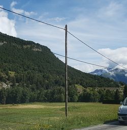
A cable installed on poles. They can be seen in forests or narrow environments. This makes a strong difference with uninsulated power lines, more vulnerable to climate impacts. |
location:transition=yes may be used on nodes connecting two different cable sections with different location=*s. It is even better on the end node of a power line or cable disappearing underground without more knowledge.
Lifecycle
Please refer to similar and more detailed lifecycle directions on power=line page.
How to detect an underground cable
Common tagging mistakes
Examples
| Photo | Location | Tagging | Note |
|---|---|---|---|
 |
Germany | power=cablevoltage=380000cables=6circuits=2tunnel=yeslocation=underground
|
Two circuits power cable installed in a tunnel in the Berlin underground |
 |
France | power=cablevoltage=220cables=2location=overhead
|
Overhead cables suspended on wooden poles |
Rendering
Power cables aren't shown on OSM Carto and the following services are available:
- Open Infrastructure Map
- Power Grid Map
- Electricity grid map (Europe only)
- Maperitive power line rule set for rendering power lines, cables and substations in Maperitive.
See also
- Power_networks and associated local projects.
- Power transmission refinement proposal


