File:San Andreas southern margin - landsat and OCHA and OSM data.png
Jump to navigation
Jump to search

No higher resolution available.
San_Andreas_southern_margin_-_landsat_and_OCHA_and_OSM_data.png (461 × 351 pixels, file size: 131 KB, MIME type: image/png)
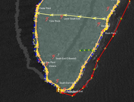
This image is centered around 12.5N-81.7W showing the southern margin of San Andreas, Colombia. The grey line is the proposed OCHA boundary import for the San Andreas Municipality; the imagery is Landsat. Note the offset of OCHA boundary vs. Landsat+OSM data (including PGS coastline).
Licensing
![]()
The creator of this work, ceyockey, has released it into the public domain. This applies worldwide.
In case this is not legally possible, the creator has granted anyone the right to use this work for any purpose, without any conditions, unless such conditions are required by law.
Notice to creator or uploader: CC0 license might be more suitable. "Releasing work to public domain" has some issues, as it is not well defined in some jurisdictions and/or it is not actually possible to "release to public domain". Using CC0 license achieves the intended effect while avoiding such problems and is well suited for media files.
File history
Click on a date/time to view the file as it appeared at that time.
| Date/Time | Thumbnail | Dimensions | User | Comment | |
|---|---|---|---|---|---|
| current | 21:35, 28 December 2010 | | 461 × 351 (131 KB) | Ceyockey (talk | contribs) | This image is centered around 12.5N-81.7W showing the southern margin of San Andreas, Colombia. The grey line is the proposed OCHA boundary import for the San Andreas Municipality; the imagery is Landsat. Note the offset of OCHA boundary vs. Landsat+OSM |
You cannot overwrite this file.
File usage
The following page uses this file: