File:UniDela.png
Jump to navigation
Jump to search


Size of this preview: 728 × 600 pixels. Other resolutions: 291 × 240 pixels | 583 × 480 pixels | 773 × 637 pixels.
Original file (773 × 637 pixels, file size: 268 KB, MIME type: image/png)
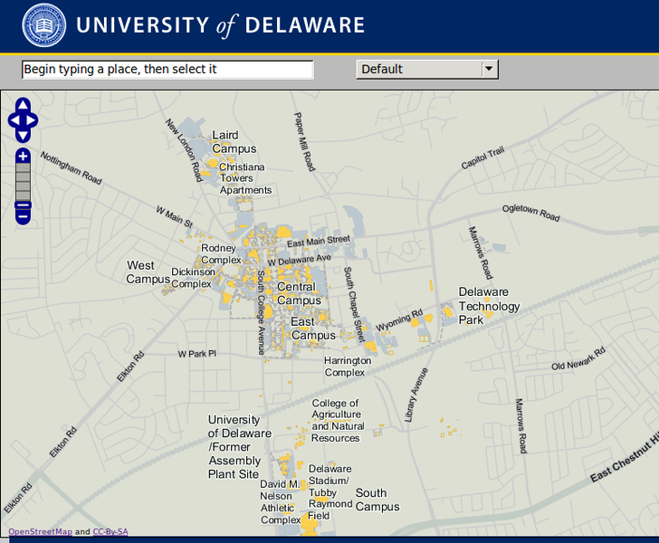
University of Delaware has rolled out a campus map that is based on OpenStreetMap.
CC-By-SA
This is a Featured image, which means that it has been identified as one of the best examples of OpenStreetMap mapping, or that it provides a useful illustration of the OpenStreetMap project. If you know another image of similar quality, you can nominate it on Featured image proposals.
Front-page image for week 6 of 2011 (7–13 Feb.).
- Image descriptions
- Deutsch : Campusplan, Hochgeladen zu OSM durch die Universität von Delaware (siehe auch die auswählbaren Vektorgebäude auf deren Webseite!)
- English : Campus map uploaded to OSM by University of Delaware (and see the selectable vector buildings on their website!)
- français : Carte du campus ajoutée à OSM par l'Université du Delaware (voir aussi les bâtiments vectoriels sélectionnables sur leur site !)
- italiano : Mappa del campus universitario caricata su OSM dall'Università del Delaware (sono degni di nota gli edifici selezionabili sul loro sito web!)
- lietuvių : Stovyklos žemėlapis, įkeltas Delavero universiteto (pabandykite paspausti ant pastatų jų interneto puslapyje!)
- polski : Mapa kampusu wgrana do OSM przez Uniwersytet Delaware. Zobacz też interaktywne wektorowe obrysy budynków na ich stronie.
- български : Карта на кампуса качена в OSM от Университета на Делауеър. (Сградите могат да бъдат селектирани направо на уебсайта!)
- русский : Карта территории загружена на OSM университетом Делавэра (и обратите внимание на выделяемые векторные здания на их сайте!)
File history
Click on a date/time to view the file as it appeared at that time.
| Date/Time | Thumbnail | Dimensions | User | Comment | |
|---|---|---|---|---|---|
| current | 17:14, 31 January 2011 | | 773 × 637 (268 KB) | Rw (talk | contribs) | University of Delaware has rolled out a campus map that is based on OpenStreetMap. CC-By-SA |
You cannot overwrite this file.
File usage
The following 9 pages use this file: