File:Waterloo and South Bank cake diagram.png
Jump to navigation
Jump to search


Size of this preview: 695 × 600 pixels. Other resolutions: 278 × 240 pixels | 556 × 480 pixels | 921 × 795 pixels.
Original file (921 × 795 pixels, file size: 556 KB, MIME type: image/png)
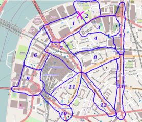
London/Summer 2010 mapping parties cake diagram for Wednesday 15th Sept
Attendees
Original sign up list. Feel free to edit with who was really there.
- Harry Wood slice 2 - Doing building outlines for the CloudMade offices!
- Also with David joining me for a demonstration.
- Derick Rethans slice 1.
- TomChance slice 5 (probably with some other cycle parking mapping along Southwark Street)
- Matt slice 3.
- Firefishy - London Cycle Hire!
- Dan Karran slice 13
- Clare Seldon - Slice 4
- Andrew slice 11
- edit the page to add your name here
Licensing
![]()
![]()
![]()
This screenshot contains OpenStreetMap Carto rendering.
The OpenStreetMap Carto map style is made available under the Creative Commons CC-0 1.0 Universal Public Domain Dedication.
- Attribution to the map data:
![]()
Contains map data © OpenStreetMap contributors, made available under the terms of the Creative Commons Attribution-ShareAlike 2.0 (CC-BY-SA-2.0).
File history
Click on a date/time to view the file as it appeared at that time.
| Date/Time | Thumbnail | Dimensions | User | Comment | |
|---|---|---|---|---|---|
| current | 13:31, 1 September 2010 | | 921 × 795 (556 KB) | Harry Wood (talk | contribs) | London/Summer 2010 mapping parties cake diagram for Wednesday 15th Sept |
You cannot overwrite this file.
File usage
There are no pages that use this file.