Geohash
Geohash is a public domain geocoding system that encodes a geographic location (LatLong) into a short string of letters and digits (a base32 positive integer number).
Geohash is a de facto standard to enconde LatLong coordinates in only one number, accepted by PostGIS and many others tools.
Tools
OSM Tools:
- JOSM GeoHash plugin displays a layer on top of the JOSM map that contains the corresponding geohashes, up to a depth of 10. This means that the geohash can have a code length of maximum 10 characters.
- ... OSM's API to express Geohash as reliable short link? (see help.openstreetmap.org/questions/65670).
Non-OSM to OSM or general use:
- Functions ST_GeoHash(), ST_Box2dFromGeoHash() and ST_PointFromGeoHash() of PostGIS.
- Geohash.org offers the
format=osmoption. Example: http://geohash.org/w21z76281?format=osm
Non-OSM to other maps:
Comparison with other solutions
Consider for example zooming in on the Singapure's Merlion (Wikidata Q208760), an ~8mx3m map feature, as element into the OpenStreetMap.
-
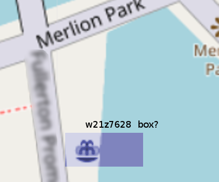 The OSM's map not show Geohash cell.
 -
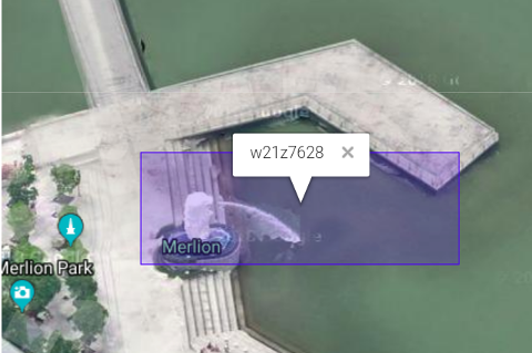
 The Map Feature: Merlion sculpture and fountain.
 -
 At GoogleMap's zoom, in its Geohash cell of ~10m×5m.
Using a 8-length code,w21z7628. The Singapure's Geohash cell isw2prefix (orw21excluding Pedra Branca island). -
 At openstreetmap.org/edit, the rose way.
PS: as there are no Permanent ID you can try to link at osm.org/way/182819157 or look for wikidata tag Q208760. -
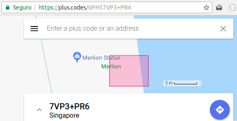 At PlusCode interface, as ~2m×2m cell. Using a 11-length code,
6PH57VP3+PR6and showing option of "cityName + localCell code" (city's local cell is the6PH5prefix).


Geohash is a kind of "hyerarchical-cells coordinate system", so can be compared with different "cell resources". Example:
- An ~10m×10m box of 6PH57VP3+PR, using PlusCode.
- An ~5m×5m box of w21z76281, using Geohash.
After 4 refinements one lands on Merlion park as 6PH57VP3+PR.
It is a 10 characters code, representing a ~10m×10m box. The same point of a ~5m×5m box in the Geohash representation, w21z76281, consumes 9 characters.
| Solution | Template URL | Pros | Cons |
|---|---|---|---|
| Geohash at OSM - ideal OSM's redirection (is a fantasi, not exists) | OSM.ORG/G{geohashCode}
|
Short URL, good and precise zoom and renderization | (no relevant problem) |
| Geohash at Geohash.org - bad OSM's redirection | geohash.org/{geohashCode}
|
Short URL | No zoom, no cell renderization |
| Geohash at movable-type.co.uk/scripts - good renderization but no redirection | 2 | 3 | 4 |
| ? Good zoom and renderization | (no redirection) | 3 | 4 |
| PlusCode | .../{PlusCode}
|
... | ... |
| Mapcode | .../{Mapcode}
|
... | ... |
| what3words ([Wikipedia](https://en.wikipedia.org/wiki/What3words))... Easy to remember... | 2 | 3 | 4 |
IMPORTANT-1: Mapcode and What3words are patented systems, so they are not suject to selection or merit, only to technical analisis.
IMPORTANT-2: the What3words strategy to translate the geo-ID into dictionary words can be reproduced by any other code, using a non-copyrighted set of words of any language. It is good to write at Telegram or Whatsapp chats, but it is not a good choice for official ID of a Map Feature or address. So it its a "secondary ID" (translated), and can enhance and can be removed from comparisons.
Administrative names conventions
Standards like ISO_3166-2 when adopted for principal subdivisions (by for instance AD, AR, BR or CL), can be conjugated with city names or city-3-letter abbreviations to express a cell (so a prefix of internal cells), a reference system or a "local BBOX". For Singapure suppose SG or SG-1.
| Solution - city | City mnemonic (len) | Prefix (len) | Complete Feature code (len) | Feature code (len) | Complete Feature alias (len) |
|---|---|---|---|---|---|
| Geohash - Singapure | SG-1 (3) | w21 (3)
|
w21z7628 (8)
|
z7628 (5)
|
SG1-Z7628 (8)
|
| PlusCode - Singapure | Singapure (9) | 6PH5 (4)
|
6PH57VP3+PR6 (11)
|
7VP3+PR6 (7)
|
7VP3+PR6 Singapure (16)
|
| Adapted PlusCode - Singapure | SG-1 (3) | 6PH5 (4)
|
6PH57VP3+PR6 (11)
|
7VP3+PR6 (7)
|
7VP3+PR6 SG-1 (10)
|
| Mapcode - Singapure | SGP (3) | SPG (3)
|
HSF9S.TNMH (9)
|
NP.PZ (4)
|
SGP NP.PZ (7)
|