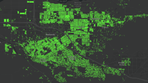
Import/City of Redlands, California Buildings
This is a completed import of municipal building and address data for the City of Redlands, California.
Goals
Import Redlands building footprints data set to complete the coverage of building footprints with addresses for the City, using authoritative data from the City that was digitized from aerial imagery. OSM currently has limited coverage for the 34,000+ buildings in the City. This import will greatly expand and enhance the coverage of buildings for the city, while retaining the buildings already added to OSM. This also includes 12,000+ address points where there is typically more than one address per building, such as apartments. In a future phase, we will plan to update existing buildings to include additional address tags where needed.
Schedule
Data preparation and import work was performed in January 2020, with the buildings import performed incrementally over a period of 2 weeks in late January and early February. The address point import was performed over a week period in early April.
Results
Through the import, there were 29,180 buildings added for the City of Redlands and local surrounding area. Of these buildings, approximately 64% included address tags (i.e. house number, city, state, and postcode). Through the second phase of the import, there were 12,048 address points added for the City of Redlands and surrounding area.
Source
Data available on City of Redlands Open Data Hub.
Latest Building Footprints and Address Points to be downloaded and processed.
OSM ODbL Compliance: Yes, explicit permission to integrate with OSM given by GIS Administrator for the City. The data is provided under a Public Domain license.
Data Preparation
After initial review of the data, the plan is to join building footprints with address points using ArcGIS software so that building footprints include address attributes.
| Source Attribute | OSM Tag |
|---|---|
| NUMBER | addr:housenumber=* |
| STREET (Calc) | addr:street=* |
| CITY | addr:city=* |
| STATE | addr:state=* |
| ZIP | addr:postcode=* |
Calc: some attributes will need to be calculated based on existing attributes in the data source.
- STREET to be pre-calculated in GIS to equal PREFIX_DR + NAME + TYPE + SUFFIX_DIR.
Data Conflation
Existing building features in OSM will not be replaced. The plan is to perform the import and conflation in phases. In the first phase, only new buildings that do not intersect existing buildings or other OSM data (e.g. water, roads) will be added. In future phases, existing buildings may be downloaded and updated to include additional address tags.
Import Type
This import was done in sections (block groups) using ArcGIS Editor for OSM. Import was tested on Development server first.
Import Account
New dedicated import account(s) to be created for import. These include:
 dkensok_redlands_import (on osm, edits, contrib, heatmap, chngset com.)
 jshimota_redlands_import (on osm, edits, contrib, heatmap, chngset com.)
Changeset Tags
Will set source = City of Redlands.

