Key:kneipp_water_cure
Jump to navigation
Jump to search
 |
| Description |
|---|
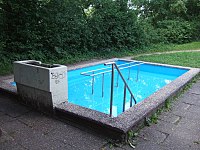
| The single basin inside a Kneipp facility. |
| Group: amenities |
| Used on these elements |
| Useful combination |
| Status: approved |
| Tools for this tag |
|
The key kneipp_water_cure=* describes basins of a Kneipp facility. It should be tagged to separate objects within the area of a Kneipp facility amenity=kneipp_water_cure.
Values
Each basin of a Kneipp facility is tagged as a node or area depending on its shape and size, using the kneipp_water_cure key and one of the following values.
| Key | Value | Element | Comment | Photo | ||
|---|---|---|---|---|---|---|
Basin | ||||||
kneipp_water_cure
|
foot
|
for a foot basin |  | |||
kneipp_water_cure
|
arm
|
for a arm basin |  | |||
kneipp_water_cure
|
user defined | All commonly used values according to Taginfo | ||||
This table is a wiki template with a default description in English. Editable here.
Useful additional Tags
See also
kneipp_water_cure:*=*– The prefix keys allow to list the different kinds of Kneipp basins at the facility