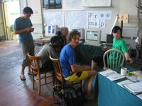
Map Limehouse Event 2005

Map Limehouse is a past event which took place in East London way back in 2005. In fact it may just be the very first ever OpenStreetMap Mapping Party! An important moment in the early history of OpenStreetMap, although at the time it was not referred to as a "mapping party". The event was called "map limehouse".
Old details
17th July 2005, Limehouse Town Hall: 646 Commercial Road, E14 7HA. 11 am - 5pm.
Map at http://osm.org/go/euu6jSAoN-?m
Blurb: Limehouse Town Hall had an open day on the 16th and 17th July, which was a big bonanza of communidee activities, a bbq, a tombola, plus collaborative cartography of various sorts. During the day the 10 workstation linux lab and however much mobile equipment we were able to put together between us was put into service to map as much of the area as we possible.
Invitation: https://lists.openstreetmap.org/pipermail/talk/2005-July/000917.html
What we learned:
- Machines should be thoroughly prepped beforehand, and gps downloads tested from each unit.
- Tom and Steve's http://www.tom-carden.co.uk/googlegpx/ google gpx viewer is a really nice 'here you go!' thing for immediately after the walk.
- Don't walk for too long without water on a boiling hot day!
- If you have lots of identical gps units, make sure you remember who was whose when you collect them for gpx track uploading
- Walking for an hour and a half generates enough tracks for something interesting.
- There are lots of streets and walkways unmarked and without names, naming streets is fun!