Microgrants/Microgrants 2020/Proposal/A 360 OpenStreetMap editor
About your project
Editor that brings a whole new perspective on how you edit OpenStreetMap.
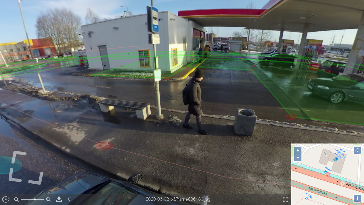
Being a web application the concept is similar to the iD editor, but instead of using traditional flat imagery it uses 360 panoramic photos as a background layer.
I have made a working prototype which does not have an editing functionality yet, but it gives an idea what it may look like: http://ownpillary.svimik.com/browse.php?img=2020-03-02-p3/frame036180.jpg&x=55&y=-19&z=54 You can zoom, pan, jump to other places, and see the OSM data overlaid on top of the photos.
While I made sure it works in most browsers and platforms, here's a screenshot just in case it's unavailable at the time of reading: http://svimik.com/360editor_screenshot.png
To make this demonstration I had borrowed a 360 camera and GPS receiver from the company I work for in order to capture the photos and then I spent some free time to make this prototype.
In order to continue developing and make it a real editor I need to invest more time than I can afford right now, and also I would need to buy some hardware and rent a server if I'm going to make it public.
What do you need the grant money for?
- Develop the web-based editor mentioned above
- Take street level imagery of my city (Estonia, Tallinn) in order to use it both as a test sample for the development and in the end use it for mapping
Budget breakdown
| Item | What do you plan to spend the money on? | Expected cost per unit (in Euros) | Quantity you plan to buy / subscription length | Expected total cost (in Euros) | Why is it needed? (Please give as much detail as possible.) |
|---|---|---|---|---|---|
| 1 | Liberating more time to work on this project | € 2 000 | once | € 2 000 | This will allow me to spend one month full-time on this project in addition to my free time |
| 2 | 360 Camera | € 599 | 1 | € 599 | This will allow me to buy the QooCam 8K camera |
| 3 | Memory card | € 68.69 | 1 | € 68.69 | The camera requires a lot of storage space, 256GB memory card would be a minimum requirement for a single trip |
| 4 | GPS receiver | € 273.80 | 1 | € 273.80 | This will allow me to buy the u-blox RTK ZED-F9P receiver with RTK antenna |
| 5 | PC w/capable hardware | € 900 | 1 | € 900 | Processing 8K images is a resource consuming process. This will allow me to buy a PC with CUDA-capable graphics card to process all the data I need |
| 6 | Server rent | € 70.11 per month | 12 months | € 841.32 | This will allow me to rent a server, so I could host the editor for public use |
If you receive a grant, what do you aim to achieve?
- The code of the editor will be published on github under an open source license (GPLv3 unless OSMF has a specific preference)
- The editor will be accessible worldwide, with a caveat that photos of certain quality will be needed in order to use it
- At first I'll be developing it with the 360 photos I will take, and then I plan to incorporate Mapillary images to make it worldwide if Mapillary allows it (the preliminary answer is yes). Naturally, direct image uploading will be supported too
- For testing, I plan to take at least 300km (likely I will do more) of imagery in my city (Tallinn, Estonia). All captured imagery will be donated for public use and uploaded to Mapillary to let other projects use them too
Do you receive funding from any other sources at the moment?
I do not receive funding from any other organisations at this moment.
Is there anything you would like OSMF to support you with?
Find volunteers to participate in the project?
Given the funding I will be able to finish the project myself, but it will be more productive if other volunteers decide to participate too. I may be able to share the row #1 of the budget with others as a bounty program if as a result of their contributions I won't have to spend as much time as intended originally.
Once it's finished, I would like help to promote the editor among the community to make sure it gets good awareness and use that means it's value to the community justifies the grant.
Declaration
By submitting this form to the OpenStreetMap Foundation, you certify the information contained in this application is correct, and that if you are awarded a grant, you will use it only for the purposes described above. You will provide written documentation and receipts for all of your expenses to the OSM Foundation to demonstrate this. You understand that the decisions made by the OSM Foundation Microgrants committee are final.
I, SviMik, agree to follow the above declaration
Endorsements
Community members are encouraged to endorse your project request here!
- I endorse this proposal. This editor should help to OpenStreetMap data be more detailed and precise. Despite the fact that the fund amount is significant, the benefits from this project will fully pay for it. Korney San (talk) 13:19, 15 May 2020 (UTC)
- I endorse this proposal. on the condition that it will be translated into different languages, including Russian – Sildream
- I endorse this proposal. Two years ago I still dreamed of such an editor and made an April Fool's joke about it. Now this dream could become a reality ;) --Supaplex030 (talk) 08:13, 20 May 2020 (UTC)
- I endorse this proposal. This would be a great way to improve accuracy of the map at street level, as satellite imagery doesn't have enough resolution for that. Asdqweasd (talk) 05:06, 21 May 2020 (UTC)
- I endorse this proposal. interesting project – Komadinovic Vanja