NaPTAN/Local schemes
The contents of NaPTAN fields vary with local authority. This page aims to keep a record of what applies to each region.
It'd be helpful if others could post examples of bus stops, so what exists in reality can be compared to the data.
Bristol
As of March 2009:
- The bearing field in NaPTAN is often incorrect showing 'N' for north rather than the correct value.
- The indicator field is often empty with the information that should be in it being appended to the Common Name, ie NaPTAN_Common_Name=Temple Meads ta, Indicator=, rather than NaPTAN_Common_Name=Temple Meads, Indicator=TA
Glasgow
- The reference used on the bus stops in Glasgow is the naptan:AtcoCode (beginning with 6090*) rather than the naptan:NaptanCode suggested on the NaPTAN/Tag_mappings page
- The name on the bus stop sign plates is usually a combination of the locality (comma) street name (slash) landmark, with common abbreviations. e.g. Denistoun, Alexanda Parade/Milnbank St - although there is often just the street name in big letters at the back of the shelter
Greater London
- Name on grey panel is the CommonName. Words in smaller font (eg [1]) also in CommonName.
- Indicator matches red roundel on pole giving the local_ref, in the format "Stop SU".
- Yellow ref number not in dataset.
- Stop reference number on label on underside of stop flag and on timetable sheets not in dataset.
- Street often present, Crossing present but always ---.
- No NaptanCodes are advertised at stops, nor in NaPTAN.
- Bearings of 'N' (north) in NaPTAN are sometimes incorrect - at one point all bearing for London in NaPTAN were N and there are still some dodgy entries.
- Non-TfL operated stops may also be present in NaPTAN (can't fully pin down this one). (See also note in Surrey section for the opposite occurring).
- [2] - Example stop
Greater Manchester
- CommonName also includes Indicator, not always formatted as on sign. eg: "Mount Road/Belle Vue (Stop B)"
- Stop reference on sign derived from AtcoCode eg: 1800EB02801
- Landmark, ShortCommonName and Street filled where applicable.
- Indicator is free-form (matching Landmark) or of format "Stop B".
- [3] - Example stop.
Hull
- AtcoCode is displayed in an abbreviated form: 2290YHA00025 is displayed as 22900025.
- Common name is good.
- ShortCommonName is arbitrary and often quite wrong.
- Indicator, when used, is free form.
- Street is accurate.
- Bearing is used with 8 cardinals. There seem to be some mistakes.
- The signs are all simple and consistent, only showing the abbreviated code [4]
Norfolk
As of March 2009 they are using 'opp' and 'adj' in the indicator field incorrectly and putting the name of the main road not the cross street into the common name, for example showing 'Common Name=High Street', 'Indicator=Adj', when actually the stop is on High Street. Having said that the situation does seem to have improved recently for some areas of Norfolk that had this problem and which have now been cleared up.
Oxfordshire
 |
 |
Many older stops in Oxford are labelled with an 8-digit number which corresponds to the imported naptan:NaptanCode=* via the E.161 phone keypad mapping: the naptan_import data uses a lowercase alphabetic version, e.g. oxfgpgam, and the ID number plates (see above) use its numeric equivalent, e.g. 69347426. Consensus so far on talk-gb-oxoncotswolds is to leave the naptan:NaptanCode=* in alphabetic form, and to stick the equivalent numbers either off the plate or derived in the ref=*.
Newly erected - last couple of months - Oxfordshire County Council signs might carry alphabetic codes, in which case that's probably what should go in the ref=*.
Surrey
- Note that London-style stops in Surrey are in the Surrey data. Even though they have London-style stop ref roundels, this data does not appear to be in NaPTAN. [5] [6]
Tyne and Wear
In NaPTAN the indicator field is often incorrectly used to hold a copy of the bearing.
West Midlands

- There are two types of bus stops: with blue flags, and with black poles. The ones with black poles are newer and have only been spotted in the centre.
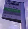
- The blue flags have a blue field with two lines: the first line is the street name (Naptan: Street), and the second line is the common name (Naptan: CommonName), often the intersecting street. Sometimes they also have a red shield on top containing the interchange name (not in Naptan) plus a two or three character reference (Naptan: Indicator in the form 'Stop YF').
- The black poles have a common name (Naptan: CommonName) and a two or three character reference (Naptan: Indicator), but no street name or interchange name.
- Neither CommonName nor Street are individually sufficient to uniquely identify a stop, but together, they are.
- A route might halt at multiple stops of the same interchange.
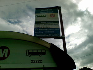
- Stops without shelters show a section of their AtcoCode on the pole. eg: 43000561201
- The reference visible on the shelter is of no relation to NaPTAN.
- Some stops have a barcode label, part of this corresponds to the AtcoCode, see inset.
- (with shelter) (without shelter)
- (Proposed) tagging scheme: For blue flags, set name=First_line_on_pole/Second_line_on_pole (this normally corresponds to Naptan:Street/Naptan:CommonName), and for black poles, set name=Text_on_pole (this normally corresponds to Naptan:CommonName). Set local_ref to the two/three character reference (this normally corresponds to local_ref=YF where Naptan:indicator=Stop YF).
York


- The txt number is part of the AtcoCode, eg: 3290YYA00145, 3290YYA00147 for the ftr and red stops respectively.
- The PlateNumber is the last 3 digits of the AtcoCode/txt code on the flags. 145 and 147 for the above.
- The Standard stop has a PlateCode in the NaPTAN data, could the flag have just been vandalised? (Unsure, as was rushing when photo taken).
- The stop letter is only included as part of the CommonName and ShortCommonName fields.
- Landmark, Street, and Crossing seem to be consistently filled.
- If Indicator is present, it is free-form, and not a repeat of other fields. Never used as a Bay/Stop etc indicator.
- Many of the metadata date stamps seem bogus - 2038-01-18T19:14:07, possibly as a result of import from a legacy system? Some timestamps seem to be genuine, a sample has seen them dated Nov/Dec 08.
- StopAreas are not used.
West Yorkshire

- Reference number is part of the AtcoCode
- About 50% of shelters have the last 5 digits of the reference number applied in larger type which is easily visible from the road.
- When part of a cluster the 2 line description at the top of the sign is replaced with a single line alphanumeric reference. (eg stops on Northgate in Wakefield are labelled N1 to N3)