Namefinder search doc
The Name Finder is an index, usually updated daily, of all the names of things contributed to OpenStreetMap. Therefore it is especially good for finding streets by name or road number. To constrain the search, you can search for a street (or something else) near a place. Name finder is located at gazetteer.openstreetmap.org.
You can find anything in the OpenStreetMap database which has been given a name (e.g. a place, street, pub, school etc., e.g. Bakers Arms) or a reference (e.g. M11 or airport code LAX), or by its type or its plural (e.g. pub or churches).
You can give just one word or several (e.g. Hinton or Hinton Road), but they must appear in the same order in what you are looking for.
Accented characters and ligatures will generally be found using their non-accented or two-character equivalents; and abbreviated words like Rd for Road and St for Street or Saint will generally be treated as equivalent to their full form and vice-versa. More information about this on the Name Finder page
Search near a place
In particular, you can restrict your search to a particular place using a comma or the word 'near' (lower case only) to separate the two (e.g. Hinton Rd, Cambridge). You can distinguish the several places of the same name (e.g. Cambridge in Cambs, Gloucs UK, Ontario Canada; Mass USA etc.) by asking for the county or country after another comma (e.g. Coronation, Cambridge, England), assuming the place includes the information (with the OSM 'is_in' tag).
You can also use a latitude,longitude either as the search phrase or the place qualifying the search, hence pubs near 52.2,0.19.
If you want to discriminate by type where things have the same name, put this after the name. For example: Chinley Station will give you the railway station (and in this case, also Station car park,as station appears in the name of the car park) while Chinley village will give you the village. This doesn't apply to streets: you can't say Hinton Road highway for example.
Examples
Fulbourn
- finds anything called or containing Fulbourn in its name:
  Village Fulbourn about 7 km east of Cambridge.

  Unclassified road Fulbourn Old Drift (east), about 2 km south of Teversham
Hinton Road, Fulbourn
Hinton Rd near Fulbourn
- equivalent to above
hospitals near Fulbourn
- churches, pubs, supermarkets, stations, atms ...
post offices near Cambridge, UK
- there's also Cambridges in Ontario, Gloucestershire, Massachusetts and several others
places near Fulbourn
suburbs near Cambridge
airports near Cambridge
airports
- not that helpful, you'll just get a random 30 of them
Victoria pub, Oxford
- as opposed to Victoria Station, Victoria Road etc, even though 'pub' doesn't appear in the name
52.18,0.20
- where is this latitude,longitude?
Requested location, about 1 km west of Fulbourn
Hinton Road near 52.18,0.20
- qualifying which one, using is_in
pubs near 52.18,0.20
villages near 52.18,0.20
Geonames
(NB. Concerns have been raised about how 'free' the data used by Geo Names is. )
Geonames (geonames.org) is a wiki-style database of names of all kinds of feature, but particularly places, together with their locations and other information such as alternate languages, elevation, population and others from various sources.
When you enter just a name of a place (lake, mountain, river etc) in the search box you are likely to get one or more locations from Geonames in the results panel. However, bear in mind that these locations may not have been added to the OpenStreetMap, so viewing a Geonames-located place may just show a blank map; or it may have no detail.
Geonames is unlikely to locate individual streets for you.
postcode support in Geocoder.XX
UK Postcodes
When you search for a UK postcode, OpenStreetMap consults NPE/Free The Postcode, a database of geolocated postcodes contributed to by people who know both a postcode and its location. It is not very complete, but can find partial postcodes.
UK postcodes are one or two letters, followed by one or two numbers, and in London sometimes a further letter, a space (which can be omitted), and then a further digit and two letters. For example:
 CB21 5DZ
 SW1A 0AA
 N4 7TJ
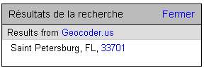
US ZIP Codes
When you search for a US ZIP code, OpenStreetMap consults Geocoder.us, which has a database of geolocated ZIP codes.
US Zip codes are either five digits, or five digits followed by a hypen and four more digits. For example:
 55416
 33701-4313

Canadian Postcodes
When you search for a Canadian Postcode, OpenStreetMap consults Geocoder.CA, which has a database of geolocated postcodes.
Canadian postcodes are two letters separated by a digit, a space (which can be omitted), and then two digits separated by a letter. For example:
K1R 7S8
French Postcodes ( not supported)
The two first number of the postcode is the same in 99% of the number of administrative code department. So 59300 code is located in administrative department of value 59. The postcode is produced by "La Poste" who distribute letters. Many small town have the same postcode but big town have many. So the postcode is not efficient to locate the town (administrative limitation). A service offers way to search postcode from town name.
59300 Valenciennes