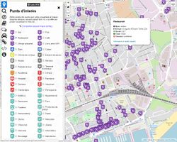
| OpenLocalMap
|
|
|
| Authors:
|
KonfrareAlbert, Yopaseopor and other contributors.
|
| License:
|
GNU GPL
|
| Platforms:
|
Windows, Linux, macOS, and Web
|
| Version:
|
1.0 (2018-01-27)
|
| Languages:
|
Catalan and Spanish
|
| Website:
|
https://osm-catalan.github.io/openlocalmap/
|
| Source code:
|
https://github.com/OSM-Catalan/openlocalmap
|
| Programming language:
|
JavaScript
|
|
Configurable and customizable OSM based map
|
Features
| Feature
|
Value
|
| Map Display
|
| Display map
|
yes
|
| Map data
|
raster;vector
|
| Source
|
online
|
| Rotate map
|
?
|
| 3D view
|
?
|
| Shows website
|
?
|
| Shows phone number
|
?
|
| Shows operation hours
|
?
|
| Routing
?
|
| Navigating
?
|
| Tracking
?
|
| Monitoring
|
| Monitoring
|
?
|
| Show current track
|
?
|
| Open existing track
|
yes
|
| Altitude diagram
|
?
|
| Show POD value
|
?
|
| Satellite view
|
?
|
| Show live NMEA data
|
?
|
| Show speed
|
?
|
| Send current position
|
?
|
| Editing
|
| Add POIs
|
yes
|
| Edit / Delete POIs
|
yes
|
| Add way
|
yes
|
| Edit geometries
|
yes
|
| Edit arbitrary tags of existing OSM objects
|
yes
|
| Edit relations
|
yes
|
| View notes
|
?
|
| Create notes
|
?
|
| Edit notes
|
?
|
| Work offline
|
online
|
| Support imagery offset DB
|
yes
|
| Upload to OSM
|
yes
|
| Rendering
?
|
| Accessibility
|
| Accessibility support
|
?
|
| Complete non graphics text output
|
no
|
| Braille interface
|
no
|
| Exploration modus
|
?
|
| Public Transport mode
|
?
|
| Danger Warnings
|
?
|
| Screenreader
|
?
|
| Screenreader languages
|
?
|
|
|
