Ortigas-Mandaluyong Mapping Party/Announcement
What is a Mapping Party?
Mapping Parties are events where anyone can come and participate in the OpenStreetMap project. OpenStreetMap is a free and open source map that can be contributed, edited and used by anyone anywhere. Mapping Parties are social events where experienced and new mappers can meet to share and learn more about the project. The events are generally held in a public place, and allow time for discussions, mapping and editing.
The event is open to all. Are you a newbie interested in OpenStreetMapping? We will help you get started right away. Are you a business owner who wants a map showing your business location? We can help get your business location in the map. Are you a Garmin GPS unit owner who wants a routable map in your device? We will load our map into your GPS unit.
It's fun. It's free. You can help.
Schedule of activities
The Mapping Party will happen the whole day of May 22, 2010, Saturday, and will consist of three parts: a morning meet-up, the actual field surveying, and the afternoon meet-up and editing session.
| Time | Venue | Activity |
|---|---|---|
| 9:00–10:00 | Starbucks Metrowalk | Morning meet-up and briefing. Participants meet up to get briefed on the day's activities and to be assigned cake slices (see below). Newbie mappers can also have an orientation regarding OpenStreetMap. |
| 10:00–3:00 | All over Ortigas and Mandaluyong | Field surveying. Participants will go around their assigned cake slices and record details or gather GPS tracks. |
| 3:00 onwards | Starbucks Megastrip | Afternoon meet-up and editing session. Participants will then converge to share stories. Those who collected GPS tracks can have them extracted from the GPS units and loaded to the OSM website or used for later editing. Newbie mappers can be given tutorials on how to start editing and contributing to OSM using Potlatch, Merkaartor, or JOSM. |
What will we map?
General objectives
- Create the most detailed map of Ortigas Center, the country's second-largest business district
- Update the map to reflect the new retail and commercial developments in the vicinity of Ortigas Center
- Complete the road coverage in the Highway Hills portion of Mandaluyong
Cake slices
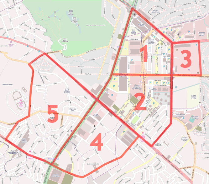
Cake slicing is a phrase used in OpenStreetMap Mapping Parties where the area to be mapped (the cake) gets divided into smaller areas (the slices) such that each slice can be surveyed and mapped by around one to three people. It's basically your simple divide-and-conquer approach to mapping! The assignment of which cake slices will be surveyed by which people will be done during the briefing in the morning.
| No. | Area | Things to map | Assigned people |
|---|---|---|---|
| 1 | Northern Ortigas Center. Bounded by EDSA, Ortigas Ave., Meralco Ave., and Julia Vargas Ave. | Complete the buildings and major POIs | |
| 2 | Southern Ortigas Center. Bounded by EDSA, Julia Vargas Ave., Meralco Ave., and Shaw Blvd. | Complete the buildings and major POIs | |
| 3 | Metrowalk and Ortigas Home Depot area. Bounded by Meralco Ave., Ortigas Ave., Valle Verde 4, and Julia Vargas Ave. | Add the service roads, buildings, and POIs | |
| 4 | Greenfield District. Bounded by EDSA, Shaw Blvd., and Pioneer St. | Complete the buildings, areas, and major POIs | |
| 5 | Highway Hills, Mandaluyong. Bounded by Shaw Blvd., EDSA, Boni Ave. and the National Center for Mental Health. | Complete the roads and major POIs |
Who will attend?
You can also signify your attendance over at the Facebook event page: http://www.facebook.com/event.php?eid=121402554549978

