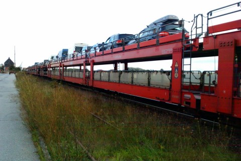
Proposal:Shuttle train
| shuttle_train | |
|---|---|
| Proposal status: | Proposed (under way) |
| Proposed by: | chris66 |
| Tagging: | route=shuttle_train
|
| Applies to: | |
| Definition: | Proposal for Shuttle Train Routes |
| Statistics: |
|
| Rendered as: | * |
| Draft started: | 2010-09-08 |
| RFC start: | 2012-03-16 |
Reason
Until now Routing applications have no possibility to route via Shuttle Trains.
Similar to Ferry-Routes on Shuttle Trains cars are transported from some start point to some end point.
Example
The Shuttle Train Route Niebüll-Westerland (Sylt/Germany) is mapped using the proposed tag.
Autoverladung Furka-Pass is mapped using the proposed tag:
Euro-Shuttle Calais-Dover is mapped using the proposed tag:
Mapping
A way with the tag route=shuttle_train is mapped from the start to the end point of the connection. On the end points the way is connected to the road network.
Instead of a way also a relation with the tag route=shuttle_train may be used (recommended).
The transition points from railway to the road network are marked with railway=car_shuttle.
Usefull combinations
The tag duration=* may be used to indicate the avarage transportation time (without transit times).
The tag access=* may be used to indicate who is allowed to use the shuttle service.
Routers
List of Routers respecting this tag (maybe incomplete):
route=shuttle_train mapped as a way:
- OSRM ( http://map.project-osrm.org )
- GraphHopper
- AIO Garmin Map
- osm2po ( http://osm2po.de/ )
- Osmand ( http://osmand.net/ )
- organic maps ( https://organicmaps.app/ )
route=shuttle_train mapped as relation:
- organic maps ( https://organicmaps.app/ )
Discussion
Please use the discussion page for comments.
Voting
Not yet started.
