Tag:attraction=water_slide
Jump to navigation
Jump to search
| Description |
|---|
| A water slide |
| Rendering in OSM Carto |

|
| Group: tourism |
| Used on these elements |
| Useful combination |
|
| See also |
| Status: de facto |
| Tools for this tag |
|
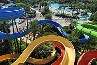
A water slide (also referred to as a flume, or water chute) is a type of slide designed for warm-weather or indoor recreational use. See water slide on Wikipedia for more details.
How to map
Map the water slide by drawing a way ![]() in the direction of the stream and add attraction=water_slide.
in the direction of the stream and add attraction=water_slide.
Note: There is a (stalled) proposal developing the tagging further as Proposed features/Extend water slides.
Useful combinations
- water_slide=*
- name=*
Examples
| Typical water slide next to a swimming pool | Multiple slides in a leisure=water_park | Indoor slide that exits/enters a building |
See also
- leisure=water_park - Water slides are common features of a water park.
- leisure=swimming_pool - Water slides usually end in a pool.


