Tag:water=oxbow
Jump to navigation
Jump to search
 |
| Description |
|---|
| U-shaped body of water formed when a wide meander from the main stem of a river is cut off to create a lake. |
| Group: water |
| Used on these elements |
| Requires |
| Useful combination |
|
| See also |
| Status: approved |
| Tools for this tag |
An oxbow lake is a U-shaped lake that forms when a wide meander from the main stem of a river is cut off, creating a free-standing body of water.
How to map
Draw the outline ![]() of the oxbow lake and add
of the oxbow lake and add natural=water + water=oxbow.
Gallery
-
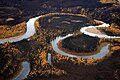 Kanuti River
 -
 Nowitna River
