Tag:wetland=fen
Jump to navigation
Jump to search
 |
| Description |
|---|
| Groundwater-fed peatforming wetland covered by mosses, grasses, sedges, reeds, and wildflowers. |
| Rendering in OSM Carto |

|
| Group: natural |
| Used on these elements |
| Requires |
| Status: de facto |
| Tools for this tag |
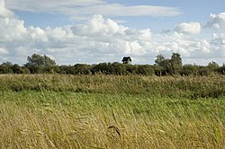
A fen is a groundwater-fed peatforming wetland covered by mosses, grasses, sedges, reeds, and wildflowers. ![]() Fens do not grow much above the groundwater level.
Fens do not grow much above the groundwater level.
How to map
Draw the outline ![]() of the area and tag it with
of the area and tag it with natural=wetland + wetland=fen.