Tag:artwork_type=land_art
Jump to navigation
Jump to search
| Description |
|---|
| Land art |
| Group: tourism |
| Used on these elements |
| Requires |
| Status: in use |
| Tools for this tag |
|
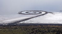
land art refers to non-figurative art of the second half of the 20th century. Usually the works are connected with plastic change and addition of the form of the earth's surface. An important feature is the connection of the work with a particular landscape and the surrounding space.
A distinctive feature of land art is the absence of references to historical characters, and other symbolic and historical load. Thus, land art should not be confused with man_made=geoglyph, which usually serves the purpose of conveying a message or symbol.
How to map
Add a node ![]() at the center, or a closed way
at the center, or a closed way ![]() around the area.
around the area.
Add the tags tourism=artwork and artwork_type=land_art.
Tags used in combination
- artist_name=*
- start_date=*
- wikidata=*
